Iraq
Diyala Governorate, Iraq — Towns & Travel Guide


Towns & cities in Diyala Governorate
Pick a town or city — each links to where to stay.
Baqubah is the practical base, the provincial capital on the Diyala River and the town nearly every trip runs through. From there the province splits three ways. Muqdadiyah lies further up the river toward the palm and orange groves of the interior, Khanaqin sits out east against the Iranian border on the Alwand tributary, and Lake Hamrin backs up behind its dam below the Hamrin hills.
Stay in Baqubah for the citrus country and the road to Baghdad; head to Khanaqin for the Kurdish-majority border towns; make for Lake Hamrin when you want the reservoir and the ridge above it.
About Diyala Governorate
Oranges made its name.
What is Diyala Governorate known for?
The groves around Baqubah earned the province its reputation as the citrus heart of Iraq, and dates and olives grow in the same well-watered fields fed by the Diyala River. Baqubah is the capital and largest town, sitting on the river about 50 km northeast of Baghdad. Further east the land climbs toward the Hamrin Mountains and the Iranian frontier, where Khanaqin and its mixed Kurdish, Arab and Turkmen population mark the border country.
Where is Diyala Governorate?
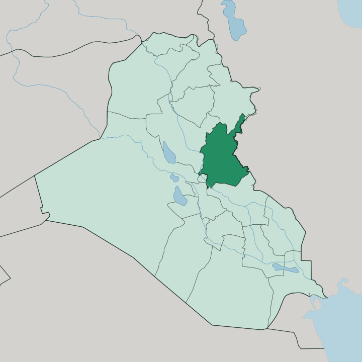
Diyala fills the northeastern corner of central Iraq. It reaches from the edge of Baghdad in the west out to the long land border with Iran in the east, a broad wedge of plain, river valley and low hill between the two. The Diyala River is the thread that holds it together.
Rising in the Zagros Mountains across the Iranian border, the river runs southwest through the province as one of the great tributaries of the Tigris, and its floodplain carries the palm groves and citrus orchards that define the settled country. Baqubah, the capital, stands on that river about 50 km northeast of Baghdad. The land is not flat everywhere.
In the northeast the Hamrin Mountains cut a low ridge across the governorate, the westernmost ripple of the Zagros, and behind their dam the Diyala backs up into Lake Hamrin. Beyond the ridge the ground climbs again toward Iran, where Khanaqin sits close against the frontier. Baghdad lies just southwest, and the Tigris runs on past it.
Water decides where people live here.
What is Diyala Governorate like?
Diyala is border country, and its mix of peoples shows it. Arabs make up the majority across the province, but the districts that run up against Iran are different. Around Khanaqin and the eastern towns the Feyli Kurds have long dominated, and pockets of Turkmen live among them, so Arabic, Kurdish and Turkmen are all heard along the frontier.
This layering is old. The province sits on the seam where the Mesopotamian plain gives way to the Zagros foothills, and it has always been a meeting place for the settled farmers of the river and the peoples of the mountains beyond. Oranges are woven into local identity as much as language is.
The groves around Baqubah gave the province its name as the citrus centre of Iraq, and the palm and olive plantations that share the Diyala floodplain shape the rhythm of rural life. Farming is the anchor. Much of the population lives in the river towns strung along the Diyala, from Baqubah to Muqdadiyah, rather than in one dominant city.
That gives Diyala a dispersed, agrarian character, tied to the water and the land it feeds.
What is the history of Diyala Governorate?
The Diyala valley has carried traffic for millennia. Baqubah grew up as a station on the Nahrawan Canal in Abbasid times, its orchards proverbial for their fruit, and it later took the main road east from Baghdad toward Khurasan when the older route silted up. Trade and water made it.
The wider province stands on the seam between the Mesopotamian lowlands and the Zagros, so armies, caravans and rival empires all passed through its river gaps. That frontier role never really ended; the border districts around Khanaqin still hold the mixed populations that centuries of crossing left behind.
What is the climate of Diyala Governorate?
Diyala runs hot and dry. It has a hot semi-arid climate, with long scorching summers, short mild winters, and rain that falls only in the cooler months. Nearly everything depends on the Diyala River, because the sky delivers so little; the province leans on the flow held in Lake Hamrin to carry its orchards through the dry season.
Drought has bitten hard as the river's inflow from the Zagros has thinned, and the reservoir behind the dam has shrunk with it. The water, not the weather, sets the limits here.
How do you get to Diyala Governorate?
Baghdad is the way in. The province has no major airport of its own, so travellers fly into the capital and drive northeast, reaching Baqubah on the Diyala River in about an hour. Roads then fan out along the valley to Muqdadiyah and up to the border towns.
Khanaqin, out east against the Iranian frontier, is the main overland crossing point toward Iran. Inside Diyala the river valley carries the main roads, linking the orange country around Baqubah with the Hamrin hills and the eastern border.
Good for
Updated July 2026