Russia
Yamalo-Nenetskiy Avtonomnyy Okrug, Russia — Towns & Travel Guide


Yamalo-Nenets is Arctic Russia's gas heartland, a tundra region of reindeer herders reaching from the Ural foothills to the Kara Sea.
About Yamalo-Nenetskiy Avtonomnyy Okrug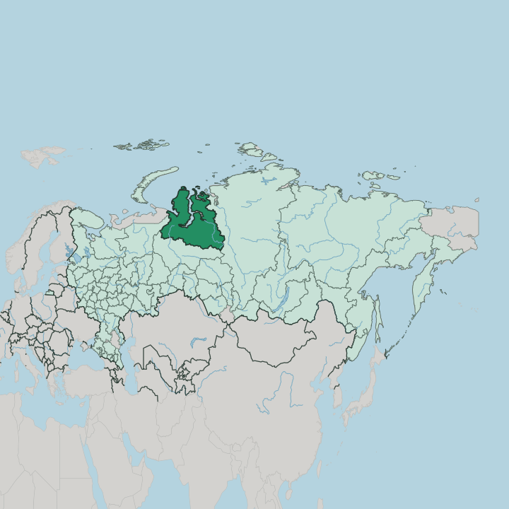
Towns & cities in Yamalo-Nenetskiy Avtonomnyy Okrug
Pick a town or city — each links to where to stay.
Salekhard is the obvious base. It is the one city that sits exactly on the Arctic Circle, at the point where the Poluy meets the Ob, and it is where spring reindeer festivals and trips out to Nenets camps in the tundra begin. Novy Urengoy and Nadym are gas towns further east, built for the industry rather than the traveller, with functional hotels for anyone routing through the fields.
Beds thin out fast beyond the towns. Choose Salekhard if you want the Arctic Circle, the museums, and a way onto the Yamal Peninsula; choose the gas cities only when work or a flight connection puts you there.
About Yamalo-Nenetskiy Avtonomnyy Okrug
Two things define Yamalo-Nenets: natural gas and reindeer.
What is Yamalo-Nenetskiy Avtonomnyy Okrug known for?
The region supplies the overwhelming share of Russia's gas, most of it drawn from the giant Urengoy field beneath the tundra near Novy Urengoy. Above that same tundra, Nenets herders drive their reindeer across the Yamal Peninsula on one of the longest seasonal migrations on Earth. Salekhard, the capital, sits astride the Arctic Circle on the Ob.
Gas towers and nomad tents share the same frozen plain.
Where is Yamalo-Nenetskiy Avtonomnyy Okrug?
Yamalo-Nenets fills the Arctic north of western Siberia, a level, waterlogged plain that runs from the Ural Mountains in the west out to the Kara Sea. It is one of Russia's largest regions and among its emptiest. The name comes from the Yamal Peninsula, one of three great fingers of tundra the region pushes into the Arctic Ocean, alongside the Gyda Peninsula and the Taz Peninsula.
Between them the Gulf of Ob reaches inland for hundreds of kilometres, the longest estuary in the world, carrying the Ob north to the Kara Sea. Water fills the tundra in every direction. Nearly 300,000 lakes pit the tundra, and swamp covers much of the ground that is not frozen outright.
The far west is different. There the northern spur of the Ural Mountains rises in a narrow chain, the only real relief in a region that is otherwise flat from horizon to horizon. Salekhard stands at the region's south-western edge, on the lower Ob where the Poluy joins it, the single city anywhere in the world laid directly across the Arctic Circle.
Everything north of it is permafrost, tundra, and the long reach of the Ob toward the sea.
What is Yamalo-Nenetskiy Avtonomnyy Okrug like?
The region takes its name and much of its identity from the Nenets, the Samoyedic people who have herded reindeer across this tundra for centuries. They are the largest indigenous group of the Russian north, and the Yamal Peninsula holds the world's biggest concentration of tundra reindeer husbandry. Herding families still live in the chum, a conical tent of reindeer hide that they strike and raise again every few days as the herd moves.
Their year is a migration. Following the reindeer between winter forest pastures and the open summer tundra, some families travel close to 1,000 kilometres and back, one of the longest herding routes anywhere. That older world runs alongside a very new one.
Gas built cities like Novy Urengoy and Nadym almost from nothing within living memory, and workers came from across Russia to live and drill in a place with eight-month winters. Salekhard, on the Ob, keeps the region's museums and its memory of the pre-oil north. Reindeer sleds and gas rigs are not a contradiction here.
They are simply the two lives the tundra now carries at once.
What is the history of Yamalo-Nenetskiy Avtonomnyy Okrug?
The Nenets Okrug was drawn up in 1930, carved out of the Soviet north as a homeland for its reindeer-herding people. Its capital had older roots: the trading post of Obdorsk on the Ob, renamed Salekhard in 1933. For a stretch under Stalin the region held part of the abandoned Salekhard-Igarka Railway, a forced-labour line pushed east across the tundra and left unfinished at his death.
Everything changed with gas. The Urengoy field, found in the 1960s and drilled from the 1970s, turned an Arctic backwater into the engine room of Russian energy.
What is the climate of Yamalo-Nenetskiy Avtonomnyy Okrug?
This is a subarctic land of long, hard winters. Cold grips the tundra for up to eight months, with January around Novy Urengoy sinking far below freezing and strong winds scouring a thin snow cover across the open plain. Summer is short and abrupt.
In July the same tundra thaws to a green, boggy carpet, with brief mild spells that let the Nenets move their herds north to open pasture. The Kara Sea keeps the far north raw and slow to warm even then.
How do you get to Yamalo-Nenetskiy Avtonomnyy Okrug?
Nearly everyone flies in. Salekhard, Novy Urengoy, Nadym and Noyabrsk each have airports with scheduled links to Moscow and the larger cities of the Urals and Siberia, and for most of the region a plane is the only practical way in. No through railway crosses the tundra to the far north; the Soviet line toward Igarka was never finished.
In the brief navigation season, river craft work the Ob down toward the Gulf of Ob and the Kara Sea. Once you land, distances between the towns are long and roads are few.
Good for
Updated July 2026