Saudi Arabia
Al Bahah Region, Saudi Arabia — Towns & Travel Guide


Al Bahah is Saudi Arabia's smallest region, a cool highland of forests and stone towers above the Tihamah.
About Al Bahah Region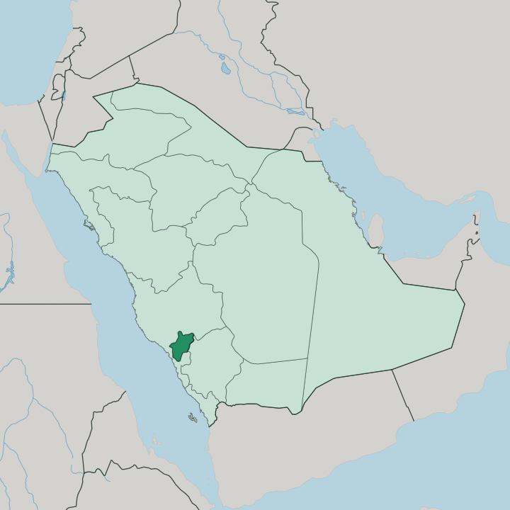
Towns & cities in Al Bahah Region
Pick a town or city — each links to where to stay.
Al-Baha city is the obvious base. The capital sits right on the Sarawat escarpment, minutes from Raghadan Forest, and holds most of the region's hotels and the cool ridge-top parks that fill through the summer. Baljurashi, the largest town by area, lies south along the high road if you want the quieter highland end of the province.
Down at the foot of the mountains, near Thee Ain and the Tihamah plain, beds are few and the draw is the old stone villages rather than any resort. Stay in the capital first; drop down toward the Red Sea only for the heritage sites.
About Al Bahah Region
Al Bahah is green.
What is Al Bahah Region known for?
That surprises people who expect Saudi Arabia to be all desert, because this highland province sits high enough in the Sarawat Mountains to hold fog, forest and a mild summer that draws visitors up from the hot lowlands. Raghadan Forest above Al-Baha city is the best-known of the region's wooded escarpments. Old defensive watchtowers of dry stone stand across its ridges and terraces, so many that the province is nicknamed the land of a thousand towers.
Between the peaks and the Red Sea plain, the drop is steep and abrupt.
Where is Al Bahah Region?
Al Bahah is the smallest of Saudi Arabia's regions, tucked into the southern Hejaz where the Sarawat Mountains run down toward the Red Sea. Two worlds meet inside its border. The eastern half rides the crest of the Sarawat, a wall of steep cliffs and deep valleys standing well over a mile above the sea, cool and wooded where the fog catches on the ridges.
West of that crest the land breaks sharply downward to the Tihamah, the hot coastal plain that runs along the Red Sea toward the Arabian lowlands. That escarpment edge is the province in miniature. Pine, juniper and terraced fields cling to the cool crest, while palm and banana groves and hard heat mark the plain below. Mecca Province wraps around Al Bahah to the north, west and south-west, and Asir Province adjoins it to the south-east, so the region sits as a small green island between two much larger neighbours.
Al-Baha city holds the high ground near the top of the escarpment. Baljurashi and the other towns string south along the same ridge line. The old marble village of Thee Ain clings to the slope where the mountains drop toward the plain.
For all its small size, few places in the country pack so much change of altitude into so short a distance.
What is Al Bahah Region like?
This is tribal highland country. Al Bahah is the homeland of the Ghamid and Zahran, two branches of the old Azd stock whose villages and terraced fields have worked these Sarawat slopes for centuries. Their mark is written into the land as dry-stone architecture.
Watchtowers of stacked slate once guarded the plantations, the paths and the passes between rival villages, and enough of them survive that the province carries the name of the land of a thousand towers. Stone is the local material and the local craft. Whole hamlets were raised from flat slabs laid without mortar, the marble-white village of Thee Ain being the most complete of them, terraced up its rocky hill above the palm groves.
Honey is the other pride of the region. Bees worked across the mountain blossom yield a crop celebrated at the province's honey festivals, and beekeeping remains a serious highland trade rather than a curiosity. Summer brings its own rhythm.
As the lowlands bake, families come up to the cool of Al-Baha city and its forests, and the season turns into a round of open-air festivals and markets. Arabic is the language throughout, as across Saudi Arabia. What sets the province apart is the mountain setting that shaped how its people built, farmed and defended what they had.
What is the history of Al Bahah Region?
Long before it was a province, this was Azd country. The Ghamid and Zahran tribes settled these Sarawat heights in the pre-Islamic centuries, and the region carried old trade and pilgrim routes climbing between the Red Sea plain and the interior of the Hejaz. Stone towers and terraced villages such as Thee Ain, whose houses go back to the eighth century, record generations of that mountain life.
Then came the modern state. The province took its present shape within the Kingdom of Saudi Arabia in the twentieth century, drawn around Al-Baha city as its capital. The towers that once divided villages now stand as its landmarks.
What is the climate of Al Bahah Region?
Altitude makes the weather here. On the Sarawat crest around Al-Baha city the air stays mild through summer and turns genuinely cold in winter, with fog and cloud snagging on the high ridges. That coolness is exactly why lowland Saudis climb up in the hot months.
Drop west to the Tihamah, though, and the picture flips: the coastal plain toward the Red Sea is hot and humid, with little rain. Two climates, one short road between them.
How do you get to Al Bahah Region?
Most travellers reach Al Bahah by road. King Saud Domestic Airport at Al-Aqiq handles internal flights only, so arriving from abroad usually means flying into Jeddah on the Red Sea coast, or into Taif or Abha, then driving up. The mountain roads are the real approach.
Highways climb the Sarawat escarpment from the Tihamah plain and run the ridge between Al-Baha city and Baljurashi, switchbacking through tunnels and hairpins as they gain the highland. It is a slow, scenic haul rather than a quick hop.
Good for
Updated July 2026