Saudi Arabia
Tabuk Region, Saudi Arabia — Towns & Travel Guide


Tabuk Region fills the far north-west of Saudi Arabia, where the Red Sea coast meets sandstone canyons and the Jordan border.
About Tabuk Region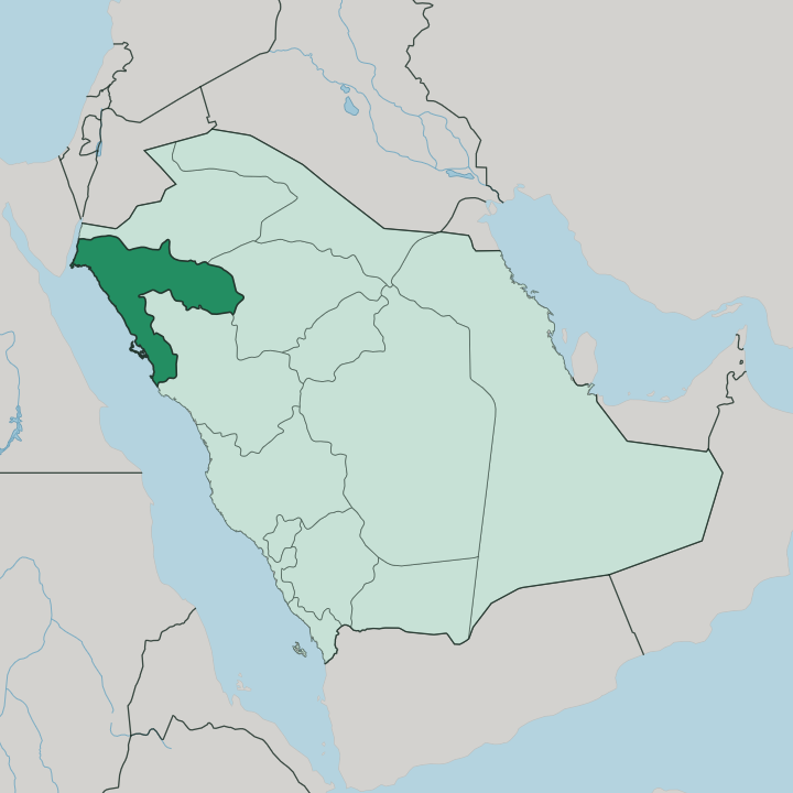
Towns & cities in Tabuk Region
Pick a town or city — each links to where to stay.
Tabuk city holds most of the region's hotels, a date-palm oasis set inland with the airport, the old castle, and the Hejaz Railway station within reach. The coast is the other choice. Umluj sits among reef islands to the south, Al Wajh keeps a quieter Red Sea harbour, and Duba and Haql anchor the shore up toward the Jordan border.
Distances are long and roads link the sites, so a car matters more than a district. Base in Tabuk city for a first visit; take the coast when the reefs and the beaches are the point.
About Tabuk Region
What is Tabuk Region known for?
Tabuk is Saudi Arabia's north-western corner. It is known for its coast. Some 700 kilometres of Red Sea and Gulf of Aqaba shoreline run along its western edge, screening more than a hundred islands and the reefs off Umluj.
Inland the land climbs into the Ḥismā, a plateau of red sandstone towers cut by canyons such as Wādī Disah. NEOM, the enormous planned development, is rising on the same north-western coast toward the Jordan border.
Where is Tabuk Region?
Tabuk Region sits in the far north-west of Saudi Arabia, the corner of the kingdom that reaches toward Jordan and the Sinai. It is large. The region covers roughly 108,000 square kilometres of desert plateau, lava field, and mountain, part of the wider Hejaz that runs down Arabia's western flank.
Two waters edge it. The Red Sea forms the long western coast, and the Gulf of Aqaba narrows to the north-west, dividing Arabia from the Sinai across a slim reach of sea. Jordan lies over the northern border, close to the city of Tabuk itself.
The land rises as it goes inland. Behind the coastal plain the Ḥismā spreads out, a plateau of red sandstone standing in isolated towers and mesas, cut through by wādīs like Wādī Disah where springs feed groves of palm on the canyon floor. Old oases punctuate the interior, Tayma among the oldest, a walled town on the caravan roads long before Islam.
Volcanic harra, black basalt from ancient eruptions, darkens stretches of the plateau. The coast is the counterweight to all that stone, its islands and reefs strung the length of the Red Sea shore, and the planned city of NEOM taking shape at the north-western end.
What is Tabuk Region like?
This is old caravan country. For millennia the north-western routes crossed here, carrying pilgrims and traders between the Levant and the holy cities to the south, and the region's character is bound up in that passage. Bedouin tribes held the plateau and its wells.
Tayma stood on the incense and pilgrimage roads as one of Arabia's most ancient settled oases, its date gardens watered from the great Bir Haddaj well. Arabic is the language, and the settled towns keep the customs of the Hejaz that shaped so much of the peninsula's history. The past is legible on the ground.
Nabataean tombs stand carved into rock at Mughair Shu'ayb, kin to the famous ones at Petra over the Jordan border, and Thamudic and Nabataean inscriptions mark cliffs across the interior. The Hejaz Railway left its own trace, a line of stone stations and rolling stock strung down from the north, and Tabuk holds one of its restored stops. Hospitality here runs to dates and cardamom-scented coffee, poured for guests as it has been on these routes for centuries.
Coast and desert keep separate rhythms. Fishing towns face the reefs while inland the oases and the herding tribes hold to a drier, harder life.
What is the history of Tabuk Region?
The land is very old. It is identified with ancient Midian, and its oases sat on the caravan roads for thousands of years, with Tayma flourishing as a trading centre where the Babylonian king Nabonidus held court in the 6th century BC. The name Tabuk entered Islamic memory in the year 630, when the Prophet Muhammad led an expedition north to the town against a feared Byzantine threat.
Centuries later the Ottomans drove the Hejaz Railway through, and its stations across the region became targets in the Arab Revolt during the First World War.
What is the climate of Tabuk Region?
Tabuk runs cooler than most of the kingdom. Its inland elevation is the reason. The city and the Ḥismā plateau sit high enough that winter nights drop toward freezing, and snow occasionally dusts the surrounding hills, a rare sight in Saudi Arabia.
Summers on the plateau still climb hot and dry, though the desert releases the heat once the sun is down. The Red Sea coast stays milder in winter but far more humid, its air heavy off the water while the interior stays dry. What little rain falls comes in the cooler months.
How do you get to Tabuk Region?
Most arrivals fly into Tabuk. The city's airport carries the region's main scheduled flights, linking it to the larger Saudi hubs, and it makes the natural landing point for the interior and the northern coast. Roads then do the rest.
Highways run down from Tabuk city to the Red Sea at Umluj and Al Wajh and north toward the Jordan border and NEOM, and a coastal airport at Al Wajh serves the shore directly. Distances are long between the sites, so travellers hire a car and drive.
Good for
Updated July 2026