Saudi Arabia
'Asir Region, Saudi Arabia — Towns & Travel Guide


'Asir is Saudi Arabia's mountain province in the south-west, where the Sarawat range climbs to the kingdom's highest peaks above the Red Sea.
About 'Asir Region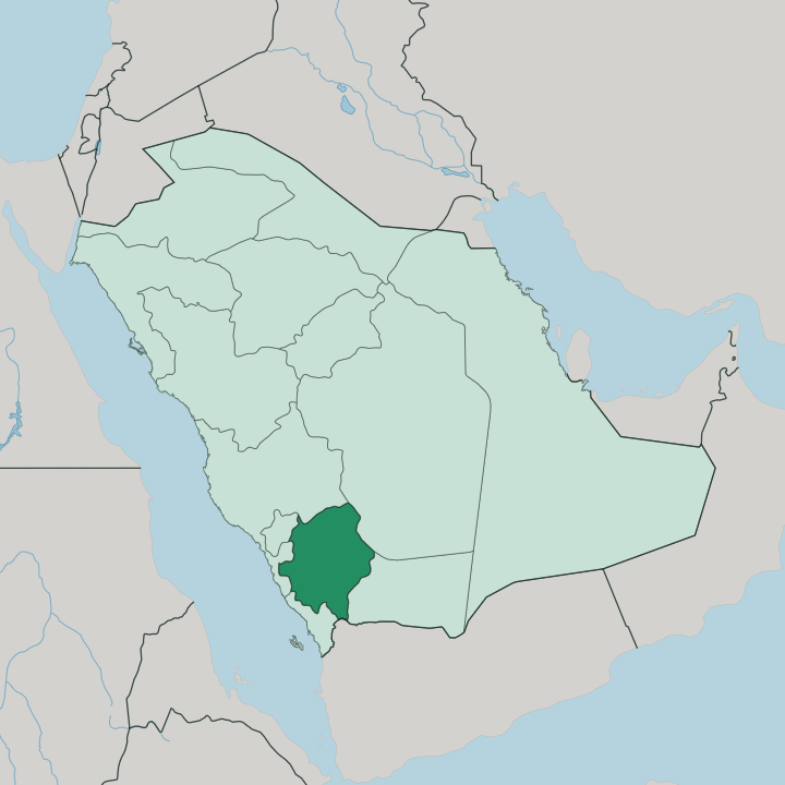
Towns & cities in 'Asir Region
Pick a town or city — each links to where to stay.
Abha is the natural base, the provincial capital set high in the mountains with hotels close to Al Basta, the dam lake, and the cable car up toward Jabal Sawda. Khamis Mushait sits just east. It carries more rooms, more restaurants, and the province's main airport, while the Soudah heights above Abha hold mountain chalets and lodges for hikers, though beds thin out fast on the summit road.
Choose Abha for your first trip and the sights within walking reach; choose the Soudah slopes when you want cool nights and juniper forest at the door. Khamis Mushait suits a later arrival.
About 'Asir Region
What is 'Asir Region known for?
'Asir is the green corner of Saudi Arabia. It rises where the Sarawat Mountains lift the south-western edge of the Arabian Peninsula, and Jabal Sawda above Abha tops out as the highest ground in the whole kingdom. The mist helps.
Cool air sets it apart from the deserts to the east, while terraced fields climb the slopes, juniper forests hold the ridges, and stone villages like Rijal Almaa cling to the cliffs. This is the mountain retreat Saudis drive to when the lowlands turn to furnace heat.
Where is 'Asir Region?
'Asir fills the south-western corner of Saudi Arabia, wedged between the Red Sea coast and the high interior. The land climbs. From a narrow coastal strip called the Tihamah, the ground rears up into the Sarawat Mountains, the range that runs the length of the western Arabian Peninsula parallel to the sea.
Jabal Sawda, north-west of Abha, is the crown of it, and Saudi authorities recognise the summit as the highest point in the whole kingdom at just over 3,000 metres. Abha, the capital, stands on the plateau behind that wall of rock. The border with Yemen runs along the province's southern edge, where the same mountains carry on into that country.
Terraced valleys thread down the western slopes toward the Red Sea, catching the rain that the peaks wring out of the clouds. Behind the crest, the land tilts east and dries out toward the sands of the interior. Water and height decide everything here.
The wet, forested west could hardly be more different from the pale desert that Saudi Arabia is known for, and the two sit within a single day's drive of each other. That contrast is the making of the province.
What is 'Asir Region like?
'Asir keeps a culture the desert never shaped. Mountains cut it off, and that isolation bred its own building, farming, and dress. The clearest emblem is Rijal Almaa, a village of tall stone-and-slate houses west of Abha that grew rich guiding caravans between Yemen, the coast, and the holy cities.
Inside those houses lives the art the province is famous for. Women paint the walls in Al-Qatt Al-Asiri, a style of bright geometric patterns in red, green, and yellow that UNESCO inscribed on its heritage list in 2017. Then there are the flower men.
In the highland tribes, men still crown themselves with garlands of fresh herbs, marigolds, and wild basil, a custom held to reach back thousands of years. The food, the music, and the terraced farms all carry the same mountain stamp. Coffee grows on the slopes here, one of the few places in Saudi Arabia where the bean is worked, along with wheat, fruit, and vegetables lifted up the hillsides on stone terraces.
Every hillside tells you people have farmed this ground for a very long time. The result feels closer to the Yemeni highlands than to Riyadh.
What is the history of 'Asir Region?
'Asir was its own country first. The Emirate of Asir, an Idrisid state founded in 1906 by Muhammad ibn Ali al-Idrisi in revolt against Ottoman rule, held these mountains and part of the Tihamah coast for nearly three decades. Ibn Saud absorbed it into the growing Saudi state, and the Treaty of Taif in 1934 fixed the settlement, splitting the old 'Asir lands between Saudi Arabia and Yemen.
The mountain tribes had guarded their independence for centuries before that. Their walled villages and hilltop watchtowers were built for exactly such a world.
What is the climate of 'Asir Region?
In 'Asir, elevation dictates the climate. 'Asir catches the most rain of any part of Saudi Arabia, because the Sarawat Mountains force the sea air upward until it spills its water on the western slopes. Abha and the high country stay mild through the summer, wrapped in afternoon cloud and mist while the lowlands bake, which is why Saudis treat the province as a warm-weather escape rather than a place to flee. Winters on the summits turn genuinely cold, and frost settles on Jabal Sawda.
Down on the Tihamah coast by the Red Sea the heat and humidity return in full.
How do you get to 'Asir Region?
Fly in. Abha's airport links the province to Riyadh, Jeddah, and other Saudi cities scattered across the mountains and desert, and Khamis Mushait sits beside it as the larger town and the road hub for the whole highland. From either, mountain roads climb to the Soudah heights and switchback down toward Rijal Almaa and the Red Sea coast.
Driving up from the lowlands means a long haul. Once you reach the hills, a car is the surest way to thread between the villages and the cliff-edge viewpoints.
Good for
Updated July 2026