Thailand
Changwat Rayong, Thailand — Towns & Travel Guide


Rayong is an eastern Gulf-coast province of Thailand, famous for Ko Samet's white sand, inland fruit orchards, and the refineries at Map Ta Phut.
About Changwat Rayong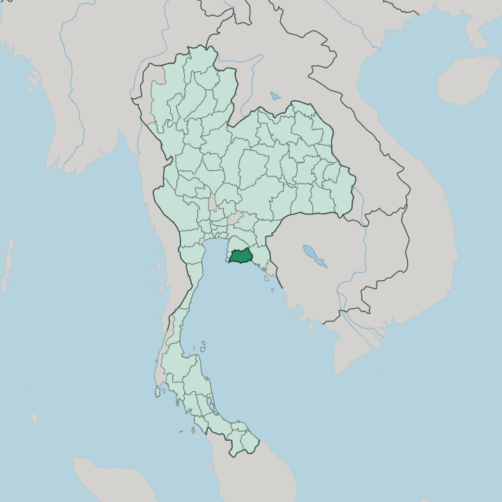


Towns & cities in Changwat Rayong
Pick a town or city — each links to where to stay.
Rayong town is the practical base, a working provincial capital at the Rayong River mouth with the widest choice of hotels and quick access west to the industrial coast. Beach travellers skip it for Ban Phe, the fishing and ferry port where boats leave for Ko Samet. The island stays drier than the mainland.
Small resorts line its eastern bays, Ao Phai and Ao Wong Duean, while east along the mainland shore Laem Mae Phim and Suan Son keep quieter sand and family lodgings. You want the coast for the sea and the town for transport.
About Changwat Rayong
Rayong earns its name two ways.
What is Changwat Rayong known for?
Most visitors come for Ko Samet, the dry, white-sand island off Ban Phe that anchors the province's beach trade. Inland the land turns to orchards, and Rayong ranks among the country's leading growers of durian, rambutan and mangosteen. The other Rayong is industrial: Map Ta Phut, on the coast west of the town, is one of Thailand's largest petrochemical complexes and a pillar of the Eastern Economic Corridor.
Fishing boats still work the Rayong River mouth as they always have.
Where is Changwat Rayong?
Rayong sits on the eastern shore of the Gulf of Thailand, southeast of Bangkok and part of Thailand's Eastern region. Chon Buri lies to the west, Chanthaburi to the east, and the Gulf fills the whole southern edge. The province is mostly a low coastal plain, cut by the Rayong River, which drains north-to-south through the provincial town and out at Pak Nam Rayong, a fishing quay at the river mouth. The Prasae River waters the eastern districts.
North of the plain the ground rises into forested hills, where Khao Chamao-Khao Wong National Park protects the watershed and the multi-tiered Namtok Khao Chamao. Beaches run almost the length of the coast. The sea does much of the work here.
A ribbon of sand called Mae Ramphueng stretches for kilometres east of the river, backed by the mainland section of Khao Laem Ya-Mu Ko Samet National Park. Just offshore lies Ko Samet, the province's best-known island, dry and rocky where the mainland is green. Smaller islets scatter further out.
The Ko Man group off Laem Mae Phim shelters a sea-turtle nursery on Ko Man Nai. It is a coast of orchards, refineries and beaches sharing one narrow plain.
What is Changwat Rayong like?
Rayong claims Thailand's most famous poet as its own. Sunthorn Phu, the early nineteenth-century court poet whose verse epic Phra Aphai Mani follows a prince, a mermaid and a sea giant, drew his island settings from this coast, and Ko Samet is the island of the tale. A memorial to him stands at Klaeng, near where his father's family lived.
On Ko Samet the sea giant Phisuea Samut rises from the water to greet arrivals at Nadan pier, and the mermaid stands along Hat Sai Kaeo beach. Poetry runs deep here. The everyday culture is coast and orchard.
Fishing fleets still land squid and shellfish at Pak Nam Rayong and Ban Phe, and the local kitchen leans hard on the catch, above all on nam pla, the fermented fish sauce the province is known for. Inland, the durian, rambutan and mangosteen harvest turns the summer into a run of fruit fairs. Every town keeps its wat, and the fruit and Sunthorn Phu festivals fill the local calendar between the fishing seasons.
A second, newer culture surrounds the refineries and car plants of the Eastern Economic Corridor, drawing workers from across the country. Thai is the language of all of it. Temples anchor the towns.
What is the history of Changwat Rayong?
Rayong steps into the record in 1570, when a Khmer raid on the town failed to take it. Its defining moment came two centuries later. After Ayutthaya fell to Burma in 1767, the general Phraya Tak, soon King Taksin, pulled his men east to Rayong, gathered ships and troops there, then pushed on to Chanthaburi to begin the reconquest.
The old town by the river grew on fishing and fruit for generations after. The newest chapter is heavy industry, and the Map Ta Phut estate rose on the coast during the industrial drive of the late twentieth century. It became a province of Siam in 1916.
What is the climate of Changwat Rayong?
Rayong runs hot and humid all year, a tropical monsoon coast. The southwest monsoon brings the rains from about May to October, and the drier, cooler months fall between November and February. Ko Samet is the odd one out.
Sheltered in a rain shadow, the island stays dry when the mainland is soaked, one of the least-rained-on spots on the whole gulf. The sea breeze takes the edge off the heat along the shore.
How do you get to Changwat Rayong?
Rayong is a road trip from Bangkok. The drive runs roughly 180 kilometres southeast of the capital, down the motorway and the old Sukhumvit highway, and buses cover the same route all day to Rayong town and Ban Phe. U-Tapao, the airport shared with Pattaya, sits out at Ban Chang on the province's western edge.
Boats handle the last leg to the islands. Ferries and speedboats cross from Ban Phe pier to Ko Samet in well under an hour.
Good for
Updated July 2026