Thailand
Changwat Nakhon Ratchasima, Thailand — Towns & Travel Guide


Nakhon Ratchasima spreads across Thailand's Khorat Plateau, from the forests of Khao Yai to the ancient Khmer temples of Phimai.
About Changwat Nakhon Ratchasima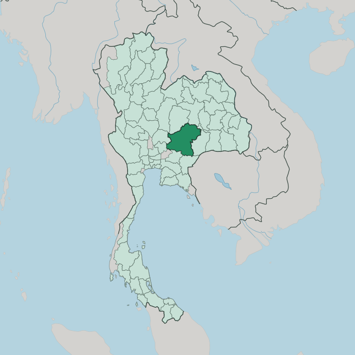


Towns & cities in Changwat Nakhon Ratchasima
Pick a town or city — each links to where to stay.
The province splits into three bases. Khorat, the provincial capital, suits first arrivals, with the Thao Suranari shrine, the old city moat, and the northeastern rail line all within the central grid. For Khao Yai National Park, the vineyards, and cooler mountain air, Pak Chong is the natural base.
Phimai rewards temple hunters. Its Khmer sanctuary sits within the old town on the Mun River, an easy hop northeast of the capital. Choose Khorat for the city, Pak Chong for the forest, Phimai for the Khmer past.
About Changwat Nakhon Ratchasima
Two draws define the province.
What is Changwat Nakhon Ratchasima known for?
Khao Yai National Park blankets the southwestern hills, a UNESCO-listed rainforest of waterfalls and wild elephants that forms part of the wider Dong Phayayen-Khao Yai Forest Complex. At Phimai stands one of the largest Khmer sanctuaries ever raised in Thailand, its sandstone towers linked by an ancient royal road to Angkor. Khorat ties the province together.
Its central square holds the Thao Suranari monument, honouring the woman who rallied Khorat against a Lao army in 1826.
Where is Changwat Nakhon Ratchasima?
Nakhon Ratchasima sits at the southwestern corner of northeastern Thailand, the first province most travellers reach when they leave the central plains for Isan. It fills the western rim of the Khorat Plateau, the raised tableland that gives the whole northeast its shape and its dry, sandy soils. To the west and south, the Dong Phaya Yen and Phetchabun mountain ranges wall the province off from the Chao Phraya basin around Bangkok, and the road east climbs through them before dropping onto the plateau.
That climb is the old divide. For centuries it marked the edge of the central kingdoms and the start of the Lao-speaking uplands beyond. The Mun River rises in the province's southern highlands, near Khao Yai, and runs east across the plateau to join the Mekong far downstream.
Khorat, the capital, stands where the highway and railway from Bangkok first meet the plateau. Khao Yai National Park rises to the southwest, its forested ridges the tallest ground for miles. Everything else is farmland.
Cassava, sugar cane, and rice cover the flat, open country between Khorat and the Khmer town of Phimai, a farmed expanse that makes this one of the largest provinces in the kingdom.
What is Changwat Nakhon Ratchasima like?
The province carries an accent all its own, the Khorat dialect, a middle tongue that sits between the Central Thai of Bangkok and the Lao-rooted Isan speech of the wider northeast. Its people are mixed. Khmer, Lao, and Chinese lines all run through Khorat.
No figure looms larger than Thao Suranari, the woman locals still call Ya Mo, whose bronze statue crowns the central square of the capital. Each spring a ten-day fair floods the streets around her monument, marking the 1826 stand against the invading army of Vientiane. Handwork is woven into Khorat's identity, from the fine silk off the looms of Pak Thong Chai to the silver-blue Korat cat that carries the province's name.
The looms of Pak Thong Chai turn out some of Thailand's finest silk, while the province lends its name to the Korat cat, the silver-blue breed pictured in centuries-old Thai manuscripts. Kitchens add their own accent to Isan food, sharpened by dishes like pad mi Korat, the province's own plate of stir-fried rice noodles. Folk troupes still perform phleng Korat, a call-and-response song traded in the local dialect.
The past sits close. At Phimai, the Khmer sanctuary still draws pilgrims and archaeologists to the northeast's greatest medieval monument.
What is the history of Changwat Nakhon Ratchasima?
History here runs in layers. Long before Thailand took shape, the Khmer empire raised the sanctuary at Phimai and linked it by a stone-paved royal road to Angkor, hundreds of miles southeast. Centuries later the Ayutthaya kings looked to the plateau as their northeastern frontier.
Around 1656 King Narai founded a walled garrison town on the site, laid out on a grid and named Nakhon Ratchasima, the border city of the realm. Then came the siege. In 1826 the townspeople, led by the woman later titled Thao Suranari, broke an occupying Lao army and sealed Khorat's place in the national memory.
What is the climate of Changwat Nakhon Ratchasima?
The plateau runs hot and dry. Nakhon Ratchasima has a tropical savanna climate, split into three clear seasons: a hot spell from March, a wet monsoon from May into October, and a cool, dry stretch over the northern winter months. Most of the rain arrives on the southwest monsoon, then drains fast through the sandy ground of the Khorat Plateau.
The hills break the pattern. Up in Khao Yai National Park the air turns cooler and wetter, its forests catching cloud that the open farmland below rarely sees.
How do you get to Changwat Nakhon Ratchasima?
Most trips start in Bangkok. From there the Mittraphap Road, Thailand's old Friendship Highway, runs northeast for some 250 kilometres, climbing out of the central plains and over the Dong Phaya Yen range onto the plateau. The northeastern railway from Bangkok to Nong Khai follows the same climb, stopping at Khorat before it fans out across Isan.
Pak Chong sits on both routes. That stop puts Khao Yai National Park within easy reach of anyone breaking the journey between the capital and the city.
Good for
Updated July 2026