Thailand
Changwat Nakhon Si Thammarat, Thailand — Towns & Travel Guide


Changwat Nakhon Si Thammarat is a province of southern Thailand, its ancient temple capital below the Khao Luang range on the Gulf coast.
About Changwat Nakhon Si Thammarat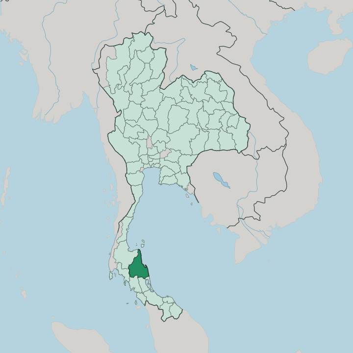


Towns & cities in Changwat Nakhon Si Thammarat
Pick a town or city — each links to where to stay.
Most visitors start in the capital. It is an inland town at the foot of the mountains, not a beach resort, and its old quarter around Wat Phra Mahathat holds the temples, fresh markets and shadow-puppet workshops. For the sea, head north to the Gulf beaches of Khanom and Sichon, quieter and cheaper than the resort islands just offshore.
Walkers go inland instead, up to the forest and waterfalls of Khao Luang National Park. Choose the city for heritage, the coast for a swim, the hills for cool air.
About Changwat Nakhon Si Thammarat
What is Changwat Nakhon Si Thammarat known for?
The province is one of the oldest settled corners of the Thai south. Its capital was the medieval city of Ligor, seat of the Tambralinga kingdom and later the Siamese governor of the whole peninsula. Wat Phra Mahathat Woramahawihan anchors the old town, a Buddhist shrine whose great white chedi has drawn pilgrims for centuries and now sits on Thailand's UNESCO tentative list.
Inland the Khao Luang range climbs to the highest summit in the south. Along the Gulf shore lie the beaches of Khanom and Sichon. Shadow puppets do the rest.
Where is Changwat Nakhon Si Thammarat?
Nakhon Si Thammarat sits on the east coast of the Malay Peninsula, in southern Thailand, with the Gulf of Thailand along its whole eastern edge. It is one of the larger provinces of the Thai south. The land splits neatly in two.
A spine of mountains, the Nakhon Si Thammarat Range, runs north to south through the interior, and from it rises Khao Luang, the highest peak in southern Thailand. East of that wall the ground falls away to a wide coastal plain that ends in the sea. Rivers born on the range cross the plain to the Gulf.
South of the capital the plain flattens into the marshes and rice country of the Pak Phanang basin, a low delta reaching out to a long sandy peninsula. Northward the coast firms up into the headlands and bays of Sichon and Khanom, the nearest mainland to the island of Ko Samui. Inland the slopes stay thickly forested, much of them protected inside Khao Luang National Park. Surat Thani lies to the north and west, and the province tapers south toward the narrow waist of the peninsula.
Sea on one side, mountains on the other. That contrast sets the shape of everything here.
What is Changwat Nakhon Si Thammarat like?
Faith runs deep in the old capital. The province is a heartland of Theravada Buddhism in the Thai south, and Wat Phra Mahathat draws pilgrims from across the country to a chedi said to shelter a relic of the Buddha himself. Around that shrine the city keeps crafts that belong to nowhere else.
Nang Talung, the southern style of shadow play, was perfected here, its figures cut and punched from translucent buffalo hide and worked against a lit screen by a single narrator. The puppet-master Suchart Subsin opened his own house in the city as a workshop and stage, and it still teaches the craft. Silversmiths keep another old trade alive, the black-inlaid niello work known as thom.
The southern character shows in food and festival alike. Cooking here is fierce with chilli and turmeric, heavier and hotter than the Bangkok kitchen. Each year the Tenth Lunar Month festival, Sart Duan Sip, brings families back to feed their ancestors, and processions of decorated floats fill the road before the provincial hall.
Islam has its place too, for this is the northern edge of the Muslim south. Old and devout, the province wears its traditions plainly. Nothing here is put on for show.
What is the history of Changwat Nakhon Si Thammarat?
The city is far older than the country around it. As Tambralinga, and later Ligor, it grew into a wealthy port trading across the peninsula between the Indian and Chinese worlds. A 13th-century chronicle credits King Sri Thammasok with refounding the town and raising Wat Phra Mahathat, and it was he who is said to have brought Sinhalese Theravada Buddhism to the Thai south.
Under Sukhothai and then Ayutthaya the city ranked as a muang ek, a first-class city governing the whole peninsula in the crown's name. Only later did it settle into one province among many. Its name honours the sacred dharma-king.
What is the climate of Changwat Nakhon Si Thammarat?
The climate is tropical and wet, and it runs against the rhythm of the rest of Thailand. While the western provinces dry out in winter, the east coast here takes its heaviest rain then. From about October into December the northeast monsoon drives moisture straight off the Gulf, and the wall of Khao Luang wrings still more of it from the clouds, so the range keeps some of the wettest country in the kingdom.
The short dry spell falls in the first half of the year, hot and hazy by April. Heat and humidity never really leave. The sea sees to that.
How do you get to Changwat Nakhon Si Thammarat?
Flying is how most arrive, with daily Bangkok services touching down at the provincial airport a short drive inland from the coast, little more than an hour in the air. The provincial airport, a short drive west of the coast, takes daily flights down from Bangkok in little more than an hour. The southern railway also reaches the city, on a branch off the main line that runs the length of peninsular Thailand, though the sleeper train is a slow overnight haul.
Buses grind south from the capital. They link the coastal districts. From the city the roads fan out to the beaches of Khanom and Sichon and inland to the foot of Khao Luang.
The ferry ports for Ko Samui sit just up the coast.
Good for
Updated July 2026