Thailand
Changwat Surin, Thailand — Towns & Travel Guide


Changwat Surin is a province of lower Isan in northeastern Thailand, known for its Kuy mahouts, elephant herds, and ruined Khmer temples.
About Changwat Surin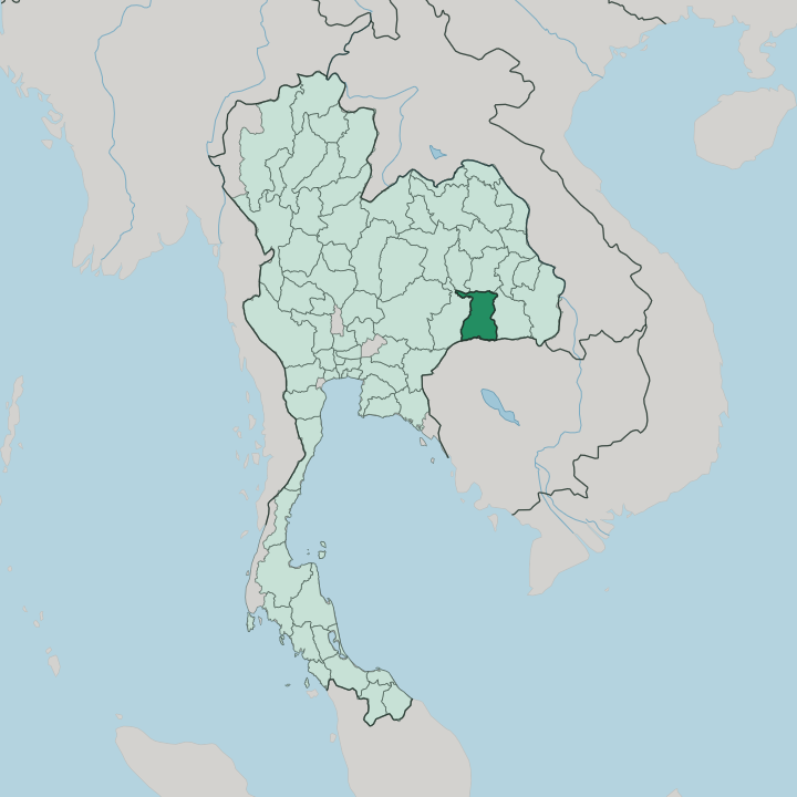


Towns & cities in Changwat Surin
Pick a town or city — each links to where to stay.
Most trips start in the capital. Surin town sits on the Bangkok-Ubon Ratchathani railway, its night market, provincial museum, and the festival ground within easy reach, and it makes the natural first base. For elephants, push north to Ban Ta Klang in Tha Tum, the Kuy village where mahouts raise the herds, though beds there run to homestays and thin out fast.
East along the rail line, Sikhoraphum puts you beside its five-towered Khmer sanctuary. Down on the Dângrêk border the Phanom Dong Rak hills hold remote ruins, but rooms are scarce and most visitors come on a day trip from town.
About Changwat Surin
The province is elephant country.
What is Changwat Surin known for?
For generations the Kuy people here have caught, tamed, and kept wild elephants, and Surin still holds roughly a quarter of all the domesticated elephants in Thailand. Many are raised at Ban Ta Klang. Each November the capital stages the Surin Elephant Round-up, a parade of scores of the animals through the streets.
Khmer ruins are the other signature. Prasat Sikhoraphum, east of the town on the rail line, still shows five brick towers on one laterite base. Handwoven silk fills the markets.
Where is Changwat Surin?
Changwat Surin lies in lower Isan, the broad northeastern region of Thailand that fills the Mun River basin. It sits on the southern rim of the Khorat Plateau. The land is mostly flat.
Low undulating plains of rice paddy stretch across the interior, rising only gently, and the small meandering streams that drain them run north into the Mun River, which clips the top of the province on its way east to the Mekong. Northern Surin edges into the Thung Kula Ronghai, a once-barren plain long prized for its jasmine rice. Sandy soils and scattered ponds mark the ground between the fields.
The south is different. There the Dângrêk Mountains climb toward Cambodia, a long forested escarpment whose cliffs drop away sharply to the plains below and mark the international frontier. The main crossing runs through the range at Chong Chom, opposite O Smach on the Cambodian side. Buriram province adjoins Surin to the west and Sisaket to the east, with Roi Et and Maha Sarakham off to the north.
Bangkok is a long way off, several hundred kilometres to the west. Much of the far south stays under forest reserve.
What is Changwat Surin like?
Surin feels closer to Cambodia than to Bangkok. Its people are a mix. Northern Khmer speakers, whose roots run back to the Khmer Empire, share the province with the Kuy and with Lao-speaking Isan communities, and many villages hear all three tongues at market.
The Kuy are the elephant people. For centuries their mahouts caught and trained wild elephants, and the bond survives in the herds kept around Ban Ta Klang and in the round-up that parades them through the capital. Stone tells the older story.
Ruined Khmer sanctuaries stand across the countryside, from Prasat Sikhoraphum on the plain to Prasat Ta Muen high on the Dângrêk escarpment, each a relic of the empire that once ruled here. Silk is the living craft. Weavers in villages such as Ban Tha Sawang work intricate mudmee and brocade patterns on hand looms, and their cloth turns up at every festival and temple fair.
The food leans hard on Isan staples of sticky rice, grilled meats, and fiery som tam. Temple fairs and the elephant festival set the calendar. It is a border culture, Thai and Khmer and Kuy at once.
What is the history of Changwat Surin?
Two histories overlap here. The first belongs to the Khmer Empire, which ruled these plains between the ninth and thirteenth centuries and left the sandstone sanctuaries that still dot the province. The second is more recent, and it begins with the Kuy.
In the eighteenth century a Kuy chief skilled in catching elephants helped recover a runaway royal white elephant for the Siamese court, and his settlement grew into the town that took his title, Surin. Siam later folded the district into its provincial system, and the changwat has carried the name since.
What is the climate of Changwat Surin?
The climate is tropical savanna, run by the monsoon. The year splits three ways. A punishing hot season from March to May bakes the Khorat Plateau before the rains break.
The southwest monsoon then soaks the province from May into October, filling the paddies, swelling the Mun River, and greening the whole plateau. Cooler, drier air settles from November, the pleasant stretch when the elephant round-up fills the capital. Rain is seasonal, not constant.
How do you get to Changwat Surin?
Most travellers arrive by rail. Surin sits on the main line from Bangkok to Ubon Ratchathani, and the overnight sleepers from the capital are the classic way in, pulling into the town station after a long run across the plateau. Buses cover the same ground from Bangkok's Mo Chit terminal.
The nearest airport is at Buri Ram, off to the northwest, with short hops to Bangkok. From the south, the Chong Chom crossing links the province to Cambodia. It is easy to reach, hard to rush.
Good for
Updated July 2026