Thailand
Changwat Khon Kaen, Thailand — Towns & Travel Guide


Khon Kaen is the road-and-rail hub of Thailand's Isan, a Khorat Plateau province of silk villages, dinosaur beds, and the winding Chi River.
About Changwat Khon Kaen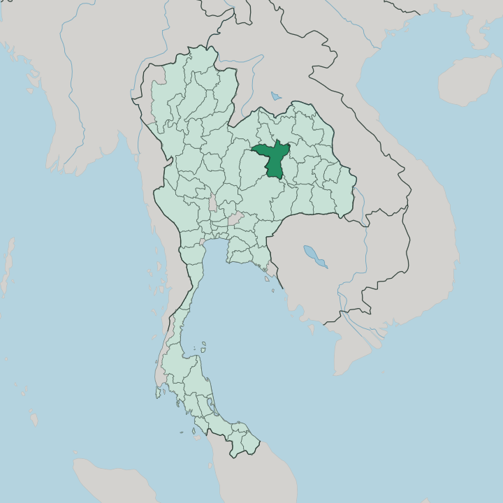


Towns & cities in Changwat Khon Kaen
Pick a town or city — each links to where to stay.
Base in Khon Kaen city. The capital rings Bueng Kaen Nakhon lake, and its markets, university, and onward trains and flights put the rest of the province within a comfortable day's reach. For water and quiet, the Ubol Ratana reservoir spreads north-west, its raft-houses and resorts backed by the wooded ridge of Phu Kao.
Chum Phae, further west, makes the natural stop for the dinosaur beds and forest trails of Phu Wiang. Chonnabot repays a visit for its silk looms, though beds are thin and most weavers are met on a day trip from the city.
About Changwat Khon Kaen
Isan knows Khon Kaen as its unofficial capital.
What is Changwat Khon Kaen known for?
The province anchors the northeast around a single university city, where Khon Kaen University draws students from across the plateau. Two things carry its name further. In the weaving village of Chonnabot, looms turn out mudmee, the tie-dyed silk that Isan is famous for, and in the sandstone hills of Phu Wiang, palaeontologists dug out Phuwiangosaurus, a long-necked plant-eater named for the ground it came from.
The golden stupa of Phra That Kham Kaen and the wide Ubol Ratana reservoir fill out the rest of the map.
Where is Changwat Khon Kaen?
Khon Kaen sits near the middle of Isan, the broad northeastern region of Thailand that fills the Khorat Plateau. The land here is not mountainous. Most of the province is low, gently rolling farmland, a tilted tableland of sandy soils that drains slowly toward the south and east.
The Chi River is its main artery, looping across the province from west to east before joining the Mun River far downstream and, with it, feeding the Mekong on the Lao frontier. Along the northern edge runs the Phong River, dammed in the hills to form the Ubol Ratana reservoir, the largest body of water for a long way in any direction. Relief gathers at the rims.
In the west and north the plateau buckles into sandstone ranges, and it is in these hills, at Phu Wiang, that the province's dinosaur beds were cut from the rock. Four national parks protect the higher ground, and Phu Wiang is the best known of them. Khon Kaen shares borders with a ring of Isan provinces, Udon Thani to the north, Kalasin and Maha Sarakham to the east, and Chaiyaphum and Phetchabun climbing away to the west. Bangkok lies far to the south-west, beyond the plateau's edge.
The city stands roughly at the centre of it all, where the main road and railway from the capital strike north toward the Mekong.
What is Changwat Khon Kaen like?
Khon Kaen is Lao at heart. Isan grew out of the Lao world across the Mekong, and its people speak a Lao-rooted dialect, press their rice sticky by hand, and pound the fiery green-papaya salad they call som tam. The soundtrack is mor lam.
Singers trade verses over the reedy drone of the khaen, a bamboo mouth-organ that has carried Isan storytelling for generations, and the modern city has pulled the old form toward the stage and the loudspeaker. Sinxay, a hero of Lao epic, is the figure the city took as its emblem. Craft runs deep alongside the music.
In the villages south of the city, above all at Chonnabot, women weave mudmee, tie-dyeing the threads before they ever reach the loom so the pattern blurs into being as the cloth grows. Devotion has its centre too, at Phra That Kham Kaen, the whitewashed stupa said to hold a relic of the Buddha and stamped on the provincial seal. For all these old roots, the place feels young.
Khon Kaen University filled the city with students and gave the northeast its main seat of learning, and the streets carry the restless energy of a campus town more than the hush of a temple market.
What is the history of Changwat Khon Kaen?
People have worked this land for a very long time. Bronze and iron tools turned up in the province point to prehistoric metalworkers on the plateau, and by the 8th century the Mon of the Dvaravati culture had left their mark, including an inscription cut in Old Mon. The modern town is far younger.
It was settled in 1783, when a local lord led a few hundred followers to the site, and it was formally established as a city in 1797. Its name comes from Phra That Kham Kaen, the old stupa that still stands north of the city.
What is the climate of Changwat Khon Kaen?
Khon Kaen runs to a tropical savanna rhythm, with the year split three ways. The cool, dry months from November into February are the kindest, when the plateau air turns pleasant and rain all but stops. Then comes the heat.
March and April bake the northeast, and the dry ground shimmers before the rains break. From May to October the southwest monsoon soaks the province, heaviest toward September, greening the paddies along the Chi River before the dry season returns.
How do you get to Changwat Khon Kaen?
Getting to Khon Kaen is easy by Isan standards. Short flights hop up from Bangkok to the city's airport in under an hour, the quickest way in. Trains are the slower pleasure.
The northeastern line from Bangkok toward the Mekong at Nong Khai runs straight through Khon Kaen, and the Friendship Highway, the old American-built road north from Nakhon Ratchasima, carries most of the buses and cars. From there the city works as the natural hub for the reservoir, the silk villages, and the rest of central Isan.
Updated July 2026