Turkey
Balıkesir, Turkey — Towns & Travel Guide


Balıkesir is Turkey's two-sea province, its olive coast strung along the Aegean and its ferry ports lining the Sea of Marmara.
About Balıkesir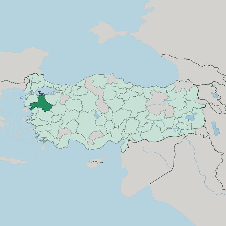


Towns & cities in Balıkesir
Pick a town or city — each links to where to stay.
Balıkesir splits into three coasts, plus its inland capital. On the Aegean, base in Ayvalık and neighbouring Cunda Island, where old Greek streets, olive groves, and seafood taverns ring the Gulf of Edremit. Altınoluk and Edremit hold the beach resorts.
They line the Olive Riviera below Mount Ida, where pine forest reaches almost to the Aegean shore. The Marmara side feels different: fast ferries from Istanbul dock at Bandırma, and nearby Erdek pairs beaches with the Kuş Cenneti wetland of Lake Manyas. Choose the coast for a holiday.
Balıkesir city, the rail junction inland, works best as a night between trains.
About Balıkesir
Balıkesir sells itself on olives and open water.
What is Balıkesir known for?
The silver-green groves around the Gulf of Edremit press some of Turkey's best-known olive oil, and the coast there, the so-called Olive Riviera, runs from Ayvalık south past Burhaniye in a line of beaches and stone harbours. Behind it Mount Ida climbs into pine and fir, the mythological Ida of the Troad. Cheese matters too.
The province's Kelle cheese travels as far as Germany, while the Marmara ports at Bandırma and Erdek draw weekend crowds off the Istanbul ferries.
Where is Balıkesir?
Balıkesir spreads across the neck of northwestern Anatolia, holding coast on two different seas. The Aegean laps its western edge, cut deep by the Gulf of Edremit; the Sea of Marmara closes the north, where the Kapıdağ Peninsula swells toward Marmara Island. Locals call it the city of two seas.
Between the shorelines the ground climbs to Mount Ida, the Kaz Dağı of the Turks, whose ridges shut off the south-western corner above the Gulf of Edremit and carry pine forest and the endemic Kazdağı fir. Five provinces ring the rest. Çanakkale lies west, İzmir south-west, Manisa south, Kütahya south-east, and Bursa east. The interior is farmland and water.
North-east of Balıkesir city, around Susurluk, a broad plain drains toward the Marmara and feeds Lake Manyas, whose reed beds form the Kuş Cenneti bird reserve. Olive groves blanket the lower slopes around the Gulf of Edremit, giving way to grain, cotton, and tobacco on the inland plains. The province is one of Turkey's largest by area.
Its beaches sit at the two far edges, but most of the land in between is working country: orchards, olive terraces, thermal valleys, and the pine highlands of Mount Ida.
What is Balıkesir like?
Life in Balıkesir turns on olives and the table they set. The oil pressed around the Gulf of Edremit flavours everything, and the province exports its Kelle cheese to Germany and Britain while sending Höşmerim, a soft dessert of cheese and semolina, to sweet-shops across Turkey. Ayvalık lent its name to the tost, a griddled cheese sandwich eaten across the country.
Food is identity here. Weekly markets in the inland towns still trade the grain, tobacco, and olives grown on the plains, and the old bathing culture survives in the thermal spa town of Gönen. The coast tells a Greek story too.
Ayvalık and its neighbour Cunda Island were largely Greek-speaking until the 1923 population exchange, and their stone churches, now mosques or museums, still line the lanes above the harbour. Inland, the culture is Turkmen and Yörük, herders who settled the Karesi country centuries ago. Folk dance runs deep.
The province's zeybek, the slow, striding dance of the Aegean efe warriors, carried a Balıkesir troupe to first prize at a French folk festival in 1958, and the tradition still fills wedding halls and town squares.
What is the history of Balıkesir?
Balıkesir grew up as the seat of the Karesi beylik, one of the Turkmen principalities that carved up north-west Anatolia after the Seljuks. Karasi Bey is said to have founded the town around 1297. The Ottomans absorbed the beylik a generation later, and its seafaring men helped carry the young state across the Sea of Marmara into Europe.
Modern history left a sharp mark. Greek forces held the region during the war that followed the First World War, until Turkish troops retook the city on 6 September 1922, the date the province still keeps as its liberation day.
What is the climate of Balıkesir?
Two climates share the province. The coasts run Mediterranean, with hot dry summers and mild, rainy winters that let olives ripen along the Gulf of Edremit and around the Marmara bays. Step inland and it hardens.
Around Balıkesir city and the interior plains, winters turn colder and frostier, the sea's softening reach blocked by the hills. Height matters as much as distance from the water: olive groves climb the flanks of Mount Ida only so far before pine forest and winter snow take over the summits.
How do you get to Balıkesir?
Most people reach Balıkesir overland from Istanbul or İzmir. The quickest crossing skips the road: fast İDO ferries run across the Sea of Marmara from Istanbul to Bandırma in about two hours, cutting out the long drive around the bay. Rail pitches in as well.
The main line up from İzmir threads Manisa and Soma before reaching Balıkesir city and carrying on north to the Marmara at Bandırma. For the Aegean beaches, a regional airport near Edremit serves the Gulf, while İzmir's larger airport backs up the whole southern coast.
Good for
Updated July 2026