Turkey
Kastamonu, Turkey — Towns & Travel Guide


A forested Black Sea province of northern Turkey, where Ottoman timber mansions climb below a hilltop castle and the Ilgaz Mountains wall the south.
About Kastamonu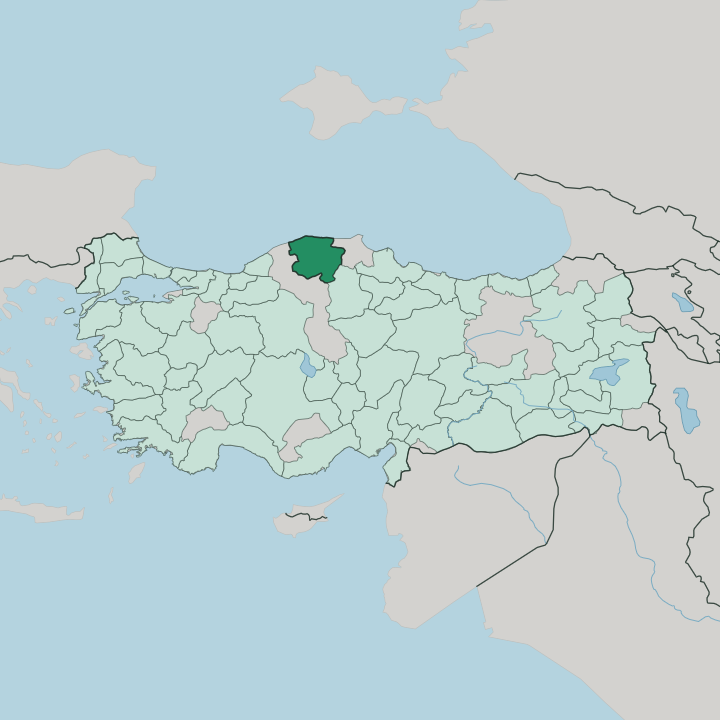


Towns & cities in Kastamonu
Pick a town or city — each links to where to stay.
Most visitors base themselves in Kastamonu itself, where boutique hotels fill restored konak mansions in the old town below the castle. The coast is the other choice. İnebolu, Abana, and Cide sit on the Black Sea an hour or two north, over the mountain passes. Skiers head instead for the Ilgaz Mountains, where the slopes above the Ankara road hold snow from midwinter deep into spring and a small resort runs the lifts.
You choose the old town for history and food, the coast for beaches, and the peaks for snow.
About Kastamonu
What is Kastamonu known for?
Kastamonu is known for the best-preserved Ottoman townscape on the Black Sea. Hundreds of timber mansions with jettied upper floors line its old lanes, watched over by a stone castle on the ridge above. The province is deeply forested.
Its garlic from Taşköprü and its pastırma are prized across Turkey, and the Ilgaz Mountains draw skiers in winter and walkers in summer. Atatürk chose the town for a famous speech. Here, in 1925, he launched the reform that abolished the fez and changed how the country dressed.
Where is Kastamonu?
Kastamonu fills a block of Turkey's western Black Sea coast. Sinop lies to the east, Bartın and Karabük to the west, while Çankırı and Çorum close off the south. The Black Sea forms the whole northern edge, a shore of small fishing harbours running for many miles below wooded hills.
Behind that coast the land climbs fast. Two mountain systems shape the province: the Küre Mountains rise near the sea in the north, and the Ilgaz Mountains wall off the south, their highest summit standing well above the treeline. Between the ranges the country folds into green ridges and narrow valleys.
Forest covers well over half the land, the densest woodland in this part of the country, fed by damp air drawn off the sea. The Gökırmak river drains the middle basin, running past Taşköprü and its old stone bridge toward the Kızılırmak beyond. In the Küre range the streams have cut deep.
The Valla and Horma canyons drop hundreds of metres into bare limestone, among the deepest gorges anywhere in the country. Kastamonu town sits inland on a high basin under its castle, closed off from the coast by the Küre wall and from the plateau by the Ilgaz ridge. That double barrier of rock has kept the province apart.
Every road in climbs a pass.
What is Kastamonu like?
Kastamonu keeps one of the best-preserved Ottoman townscapes in Turkey. Hundreds of timber-framed mansions, the konak of old merchants and officials, climb the slopes below the castle, their upper storeys jutting out over narrow lanes. Old craft quarters still work copper and weave cloth by hand.
Faith runs deep in the town's fabric. The Nasrullah Mosque anchors the market district, and above the roofs the tomb of the Sufi saint Şaban-ı Veli draws pilgrims from across the country. Out at Kasaba village stands the Mahmut Bey Mosque, a fourteenth-century wooden mosque built without nails, its carved beams and painted ceiling still intact.
Food is taken seriously here. The garlic of Taşköprü carries a protected name, the local pastırma is air-dried spiced beef, and etli ekmek, a long meat-topped flatbread, comes straight from wood-fired ovens. The province also left its mark on modern Turkey.
In this town Atatürk announced the hat reform, standing before the crowd to trade the fez for the brimmed hat, an event the local Hat Museum still records. Handwoven cloth and beaten copper fill the covered bazaar. Much of the old fabric survives for one plain reason.
The mountains kept Kastamonu off the main roads, and what progress swept away elsewhere, isolation quietly preserved here.
What is the history of Kastamonu?
Paphlagonia lent this coast its ancient name, and Rome ruled the region from Pompeiopolis, whose ruins lie by Taşköprü. Kastamonu came into its own under the Turkish beyliks that followed. It served as the seat of the Candaroğlu emirs before the Ottomans took the town for good under Mehmed II in 1461.
Its sharpest hour came far later. During the War of Independence its İnebolu harbour ran munitions inland to the front, and in 1925 Atatürk chose the town to launch the hat reform.
What is the climate of Kastamonu?
Two climates meet inside one province. The Black Sea coast around İnebolu stays mild and damp, its wooded slopes often wrapped in sea fog. Cross the Küre Mountains inland and the weather turns sharply continental.
Kastamonu town, high in its basin, sees cold snowy winters and warm dry summers, and the Ilgaz Mountains hold their snow so long that skiers ride the ridge toward Ankara well into spring. Cloud and rain favour the seaward side. That mountain snowmelt feeds the Gökırmak and the canyons below.
How do you get to Kastamonu?
Most travellers arrive from Ankara, a drive of about four hours south over the Ilgaz pass, eased by a tunnel bored under the ridge. Kastamonu keeps its own airport just outside town, with short flights up from Istanbul. By road from Istanbul the journey runs most of a day, tracing the Black Sea from the west.
The coast comes last. İnebolu sits beyond the Küre Mountains, an hour or so north of the capital by a tight switchback road.
Good for
Updated July 2026