Turkey
Ordu, Turkey — Towns & Travel Guide


Ordu is a province on Turkey's Black Sea coast, where hazelnut orchards climb from the shore up into the Pontic Mountains.
About Ordu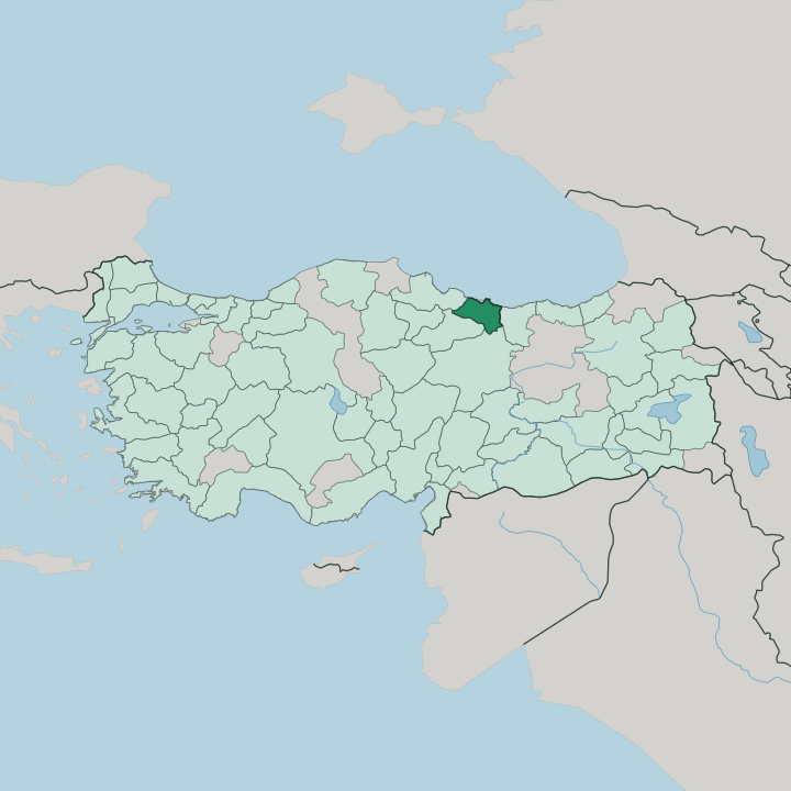


Towns & cities in Ordu
Pick a town or city — each links to where to stay.
Most first trips base themselves in the capital, Ordu, along the seafront promenade beneath Boztepe, within reach of the fish restaurants and the cable-car station. Ünye lies west along the shore, a beach town backed by the rock-cut walls of Ünye Castle, and Fatsa sits between the two as a working harbour. Perşembe holds the quieter corner. Its peninsula runs out to the chapel on Cape Jason, a favourite short trip from the city.
Head inland and up for the Çambaşı plateau, where the pace is set by pasture in summer and ski runs in the cold months. Pick the coast for beaches; pick the plateau for mountain air.
About Ordu
What is Ordu known for?
Hazelnuts made this province's name. Orchards cover most of its farmland, and Ordu ranks as the leading hazelnut producer in all of Turkey, the crop shipped down from terraced slopes to the port at the capital. The coast draws the rest of the attention, with long public beaches at Ünye and Fatsa and a cable car climbing to the lookout on Boztepe.
Kiwi vines and highland honey round out the harvest. Inland, the Çambaşı plateau turns to pasture and ski runs above the tree line.
Where is Ordu?
Ordu occupies a strip of the Black Sea coast in the north of Turkey, where the shoreline runs up against the wall of the Pontic Mountains almost at once. The land offers little flat ground. From a narrow coastal shelf the slopes rise fast, folded by valleys that carry the rain down to the sea. Giresun adjoins the province to the east and Samsun to the west, while inland the ridges climb toward Tokat and Sivas along the southern borders.
The provincial capital, also called Ordu, stands where the Melet River finishes its run to the water, on the eastern flank of the height called Boztepe. That hill shelters the town from the worst of the north-westerly storms. West of the capital the Perşembe peninsula pushes out into the sea and ends at Cape Jason, a thin cape with an old chapel at its tip.
Rivers define the interior more than roads do. The Melet River is the longest of them, and its valley is the main way up from the coast into the mountains. Higher still the forest thins to summer pasture on plateaus such as Çambaşı, and landslide-dammed hollows hold small lakes like Ulugöl.
It is a province of edges. Between the surf and the snow line lies only a short, steep climb.
What is Ordu like?
Life here runs to the rhythm of the Black Sea coast rather than the interior of Turkey. The dance says it plainly. At weddings and festivals people line up for the horon, a fast shoulder-shaking round danced to the scrape of the kemençe, the small upright fiddle of the eastern coast.
Summer empties the villages upward. Families move with their herds to the high pastures, and plateau festivals on grounds like Çambaşı fill the short mountain season with music and wrestling. The kitchen is its own argument for coming.
Anchovy, called hamsi, turns up fried, baked with rice, even folded into cornbread, and black cabbage simmers in the winter soups. Hazelnuts sweeten everything from pastries to the local chocolate. The harvest itself is a season of its own, when whole families take to the slopes to strip the bushes by hand before the autumn rain.
Faith and trade left their marks too. Old Greek and Armenian churches still stand along the shore at Ünye and out on the Perşembe peninsula, reminders of the mixed port towns this coast once held. It is a working landscape, not a stage.
What is the history of Ordu?
The coast was colonised early. Greek settlers founded a trading town here called Kotyora as far back as the eighth century BC, and Xenophon's retreating Ten Thousand are said to have rested at Kotyora for weeks before sailing on. The port passed through the kingdom of Pontus, then Rome and Byzantium, and finally the Ottomans, who valued the sheltered anchorage below Boztepe.
Its present name is younger than the settlement. Ordu means army camp in older Turkish, a name taken from a military post that once stood nearby, and the modern town was formally organised under it in 1869.
What is the climate of Ordu?
In Ordu, rain hardly ever lets up. The Pontic Mountains trap the moist air rolling in off the Black Sea, wringing it out over the coast, so the province counts among the wettest corners of Turkey with showers in every month. Winters on the shore stay mild and grey rather than hard.
Summers turn warm and humid, and the hills stay green straight through them. Climb inland and the pattern flips. The high plateaus around Çambaşı hold snow deep into spring, cold enough for a short ski season while the beaches below have long since dried in the sun.
How do you get to Ordu?
The coast road does most of the work. A single trunk highway hugs the Black Sea shore, threading the towns together and carrying most traffic in from Samsun to the west and Giresun to the east. The shared Ordu-Giresun airport handles the fastest arrivals.
It was built out on ground reclaimed from the sea, the first Turkish airport raised on the water in that way. Trains never reached this coast. Buses and cars are how nearly everyone comes, whether down the shore highway or up the river valleys from the interior, and the harbour at Fatsa still works cargo rather than passengers.
Good for
Updated July 2026