Turkey
Siirt, Turkey — Towns & Travel Guide


Siirt is a mountainous province of southeastern Turkey, cut by the Botan and Tigris rivers below the Taurus foothills.
About Siirt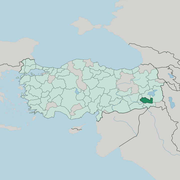


Towns & cities in Siirt
Pick a town or city — each links to where to stay.
Most trips base in Siirt itself. The provincial capital holds the bulk of the beds, gathered around the covered bazaar and the leaning minaret of the Great Mosque, and it sits within reach of the rest of the province. Kurtalan, to the west, is where the railway from Ankara ends, so travellers arriving overland often sleep there first.
Two smaller places reward a detour. Tillo draws pilgrims to its scholars' tombs, while Pervari sits high in the eastern mountains above the Botan valleys, cooler than the lowland towns. Choose the capital for a first visit; choose the districts for the hills and the shrines.
About Siirt
Siirt trades on what its hills and kitchens produce.
What is Siirt known for?
The province gives its name to a plump, round pistachio and to thick mohair blankets woven from the wool of the local goat, both sold well beyond southeastern Turkey. Pilgrims know it for other reasons. The shrine of Veysel Karani in the Baykan district draws visitors from across the country, and the scholar-town of Tillo keeps its own devotional pull.
Then there is the table. Perde pilavı, a domed rice pie baked in buttery dough, is the dish Siirt sends to weddings.
Where is Siirt?
Siirt lies in the far southeast of Turkey, in the region known as Southeastern Anatolia. It is landlocked and mountainous. The Tigris runs down its western flank, dividing it from Mardin in the southwest, while Bitlis rises to the north, Batman lies to the west, Şırnak to the south, and Van to the east.
Water defines the interior. The Botan River gathers in the high mountains toward the Van and Hakkâri border, then swings northwest through a deep gorge to join the Tigris at Çattepe, below the provincial capital. That confluence is the province's lowest and warmest ground.
Above the rivers the land climbs fast. Ridges of the Southeastern Taurus wall off the province, cut by ravines and broken by high plateaus where snow lingers late. The Botan gorge has been set aside as Botan Valley National Park, a corridor of cliffs and clear water below Siirt.
Roads twist to reach the eastern districts. Pervari and the upper valleys sit far higher than the capital, and the drive up gains altitude with every bend, which is why the mountain towns stay cold long after the lowlands warm.
What is Siirt like?
Siirt is a province of the Kurdish southeast, and its towns also hold long-settled Arabic-speaking communities. Three tongues overlap here. Kurdish, Arabic, and Turkish are all heard in the bazaars, and the mix reflects centuries of trade along the roads between Anatolia and Mesopotamia.
Faith runs deep in daily life. The province's devotional heart is Tillo, the hill-town where İbrahim Hakkı wrote his encyclopaedic Marifetname beside the tomb of his teacher, and pilgrims still climb to the shrines there. Music carries the same blend, with Kurdish dengbêj singers and Arabic laments heard at gatherings across the province.
Craft here is as distinctive as belief. Weavers here make the Siirt blanket, a dense fleecy cloth spun from the mohair of long-haired goats, and soapmakers boil the oil of the wild bıttım pistachio into a hard green bar. Food matters just as much.
Büryan, lamb lowered into a pit oven and cooked in its own steam, is the province's signature, eaten by the fistful at breakfast. Pistachios turn up everywhere. They flavour pastries, fill the domed perde pilavı, and press into the soap that carries the region's name.
What is the history of Siirt?
People have lived in these valleys since antiquity, and the land passed through Hurrian, Assyrian, Median, and Persian hands long before Islam reached it. The Seljuks left the clearest mark. In 1129 they raised the Great Mosque of Siirt, whose brick minaret still leans out over the old town.
Ayyubid, Artuqid, and Kara Koyunlu rulers held the district in turn. The Ottomans took it in 1514, after Selim I broke the Safavids at Chaldiran, and Siirt stayed under Ottoman rule for four centuries.
What is the climate of Siirt?
Siirt runs to extremes. Summers on the valley floors are long, dry, and fierce, with the heat pooling where the Botan and Tigris cut their low gorges. Winter flips the province.
Snow buries the eastern districts around Pervari for months, closing high passes, while the lowland towns stay merely cold and wet. Spring is the brief green season, when the hills flush before the summer sun scorches them brown.
How do you get to Siirt?
Siirt sits far from Turkey's main entry points, so most visitors fly. The province has its own airport on the plateau above the capital, linked by air to the big western cities. Trains reach the province too.
The line from Ankara runs east until it stops at Kurtalan, the end of the rails and, for generations, the point where the southeast joined the national network. Everything past there goes by road. Highways climb in from Batman and Diyarbakır to the west, then thread the passes to the mountain districts beyond.
Good for
Updated July 2026