Turkey
Bitlis, Turkey — Towns & Travel Guide


Bitlis is a mountainous province of eastern Turkey, wrapped around the western shore of Lake Van beneath the Nemrut volcano.
About Bitlis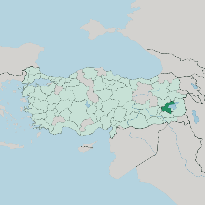


Towns & cities in Bitlis
Pick a town or city — each links to where to stay.
Most visitors base themselves in Tatvan, the biggest town, where the lake ferry and the Ankara railway meet and the mountain road climbs up to Nemrut. Bitlis is the old capital. Ahlat sits round the northern shore among its Seljuk tombs, and Adilcevaz lies beyond it beneath Mount Süphan.
Beds thin out fast beyond Tatvan. Book the lakeside towns well ahead in the snowbound months, and choose Bitlis, Ahlat or Adilcevaz when you want quieter nights near the ruins.
About Bitlis
Bitlis is Lake Van country.
What is Bitlis known for?
The province holds the western third of Turkey's largest lake, a saline soda lake so alkaline that swimmers float in it, ringed by dormant volcanoes and old lava fields. Above Tatvan rises Nemrut, whose vast caldera cradles a deep crater lake and, in one corner, a pool warmed by the mountain's own heat. Ahlat guards a field of carved Seljuk headstones and domed kümbet tombs.
The old town of Bitlis clings to a river gorge under a medieval castle.
Where is Bitlis?
Bitlis lies in far eastern Turkey, in the Eastern Anatolia Region, the highest and most mountainous part of the country. It curls around the western and south-western shore of Lake Van, the great soda lake at the heart of the Armenian highlands. Van Province faces it across the water to the east. Muş opens to the west, toward the broad Muş Plain, and the mountains fall away southward to Siirt and the Tigris basin. Little of the province sits low.
This is high, thin-aired country where the passes stay snowbound for much of the year. The province's shape is written by fire. Above Tatvan stands Nemrut, a dormant volcano whose caldera holds one of Turkey's largest crater lakes, and it was Nemrut's lava that once dammed the Van basin and sealed the lake behind it, spilling west across the Muş Plain.
On the northern shore rises Mount Süphan, a second great cone above the town of Adilcevaz. Between the peaks lies Lake Nazik, held back by an old lava flow off the Bilican Mountains. The capital, Bitlis, sits apart from all this, wedged into the steep gorge of the Bitlis River as it cuts south toward the Tigris and the plains of Mesopotamia.
That gorge has always been the door.
What is Bitlis like?
Bitlis is a Kurdish province, and Kurmanji is the first language of its villages and mountain markets, spoken alongside Turkish. Its culture is layered by everyone who has held the pass. The old town was Bagesh to the Armenians who lived here for centuries, one of the old bishoprics of the plateau.
It became the seat of a Kurdish emirate, and from that court came the Şerefname, the chronicle of the Kurdish dynasties that Şeref Han of Bitlis finished in 1597. Few provinces carry so long a memory. That past is carved in stone.
Around Ahlat, on the northern shore, medieval masons cut a whole field of headstones and raised the domed kümbet tombs of the Seljuk lords, working the soft volcanic tuff of the lakeshore. The same instinct shows in Bitlis itself, where houses are built of dark cut stone against the cold, tall and shut like small keeps. Grave-fields, minarets and fortress walls share one grammar here.
Everyday life still turns on herding, orchards and the leaf tobacco that the stone-walled terraces have grown here for generations. It is a hard landscape, handsome and deeply lived-in.
What is the history of Bitlis?
Bitlis has guarded its pass since antiquity. The plateau belonged in turn to Urartu and to Armenia, whose people knew the fortress town as Bagesh. Under the Seljuks, Ahlat grew rich on the lake trade and left its carved cemetery behind.
For centuries the pass was ruled by a Kurdish emirate whose emir, Şeref Han, sat down in 1597 to write the Şerefname, among the first histories of the Kurdish dynasties. The Ottomans absorbed it all. Its stone outlasted every ruler.
What is the climate of Bitlis?
Winter owns Bitlis. High on the eastern Anatolian plateau, the province piles up some of the deepest snow in Turkey, and the passes above the town can stay shut for months at a stretch. Nemrut and Süphan keep their snow long into spring.
Summers arrive short, hot and dry, baking the gorge while the highland nights stay cool. Lake Van softens the worst of it along the shore, where Tatvan and Ahlat run milder than the mountain villages behind them. The cold season is the long one.
How do you get to Bitlis?
There is no airport in Bitlis itself. Most travellers fly into Van, across the lake to the east, or into Muş to the west, then drive in on the D300 highway that skirts the shore through Tatvan. The railway reaches in as well, ending at Tatvan pier where a rail ferry has long crossed Lake Van.
The long line from Ankara ends at Tatvan pier, where a rail ferry has crossed Lake Van to Van for generations. From the south, the road climbs up out of the Tigris lowlands. It threads the Bitlis gorge to reach the town.
The pass still explains the province.
Good for
Updated July 2026