Algeria
Wilaya de Mascara, Algeria — Towns & Travel Guide


Wilaya de Mascara is a wine-growing province of north-western Algeria, birthplace of Emir Abdelkader and site of the Bou Hanifia hot springs.
About Wilaya de Mascara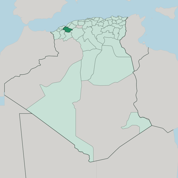


Towns & cities in Wilaya de Mascara
Pick a town or city — each links to where to stay.
Mascara town is the natural base, built on the northern slope of the Beni Chougrane hills above the Ghriss plain. Its hotels gather near the centre. North of the mountains, Mohammadia and Sig sit out on the Habra and Sig plains, working market towns strung along the road down from Oran through vineyards and orchards.
For a slower stop, Bou Hanifia keeps a few spa lodgings around its thermal springs and reservoir. Take the provincial town first; move out to the plains or the springs for open country.
About Wilaya de Mascara
What is Wilaya de Mascara known for?
Three things carry the province's name. Mascara means garrison in Arabic, and the town of Mascara gave Emir Abdelkader his first capital when he raised his resistance to French conquest in 1832. Vineyards on the surrounding hills made the Coteaux de Mascara one of Algeria's best-known wines.
At Tighennif, quarry diggers unearthed the fossil jaw of an early human that the palaeontologist Camille Arambourg named in 1954. Add the hot springs at Bou Hanifia, and the draw is history, wine, and warm water.
Where is Wilaya de Mascara?
Wilaya de Mascara lies in north-western Algeria, inland from the Mediterranean coast and roughly a hundred kilometres south-east of Oran. The province spans the Tell Atlas as it drops toward the interior high plains. The Beni Chougrane mountains run through its middle, a broken chain of green hills that separates two belts of farmland.
To the north lie the low Habra and Sig plains, watered by dams and given over to orchards and cereal. To the south opens the high Ghriss plain, some 55 km long, where the provincial town of Mascara sits above the fields on the northern edge of the plateau. Water shapes the settlement pattern.
The Oued el Hammam cuts west through the Beni Chougrane past Bou Hanifia, where a dam backs up a long reservoir and warm springs rise from the valley floor. Farther north the Oued Sig crosses the plain toward the Gulf of Arzew, held back by the Cheurfas dam above the town of Sig. Mohammadia stands at the northern foot of the hills, on the old road between Oran and Mostaganem.
Algiers is a long day's drive east. The land climbs steadily from these plains to the passes of the Beni Chougrane, and little of the province is truly flat. Vineyards and olive groves climb the lower slopes.
What is Wilaya de Mascara like?
The province wears the name of Emir Abdelkader. He was born near Mascara in 1808, and the town became the capital from which he built a state and led two decades of resistance to French conquest. Algerians treat him as a founding national figure, and his memory colours the streets, the mosque and the yearly gatherings of the provincial town.
Long before him the Ottomans had settled Andalusian Muslims here, refugees from Spain who brought orchard-craft and building trades to the hills. Wine gave the province its other reputation. The vineyards planted on the Beni Chougrane slopes yielded the strong reds of the Coteaux de Mascara, exported north through Oran and still worked across the plains.
Around them the land turns out olive oil, grain and leather, the tanners of Mascara long known for their work. Arabic is the everyday language, with the older Tamazight Berber speech surviving in pockets of the hills. Faith and learning run through it all, rooted in the religious lodges, or zawiyas, where Emir Abdelkader's own father once taught.
Markets, vines and prayer set the rhythm. It is a working countryside, not a museum.
What is the history of Wilaya de Mascara?
Mascara began as a garrison, and the name still says so. The Ottomans made it the seat of their western beylik in the early 18th century, planting a Turkish garrison and settling Andalusian families on the hillsides. Its greatest chapter came in 1832, when Emir Abdelkader chose Mascara as the first capital of the state he raised against the French, before falling back to Tagdemt when the war turned.
The modern province was drawn in 1974 from parts of the old Oran and Mostaganem departments. An earthquake shook the town in 1994.
What is the climate of Wilaya de Mascara?
The province has a dry Mediterranean climate, cooled by height on the inland plains. Summers turn hot and rainless across the Ghriss and Habra plains, while winters stay mild and carry most of the year's rain onto the Beni Chougrane. The mountains wring more water from passing storms than the plains below them ever see, so the higher slopes keep their vineyards and orchards green.
Snow dusts the ridgelines some winters. At Bou Hanifia the warm springs run whatever the season, fed from deep underground rather than the sky.
How do you get to Wilaya de Mascara?
Oran is the way in for most travellers. Its Ahmed Ben Bella Airport at Es Sénia lies about a hundred kilometres north-west of the province, and the RN6 highway runs south-east from there through Sig and up onto the Ghriss plain to Mascara town. A smaller airfield at Ghriss takes occasional domestic flights.
The drive from Algiers is a full day east. Buses and shared taxis link Mascara with Mohammadia and Sig across the plains. Rail keeps to the north.
Good for
Updated July 2026