Algeria
Wilaya de Djelfa, Algeria — Towns & Travel Guide


Wilaya de Djelfa is high sheep-steppe in the Ouled Naïl Range, where the Saharan Atlas gives way to the Sahara.
About Wilaya de Djelfa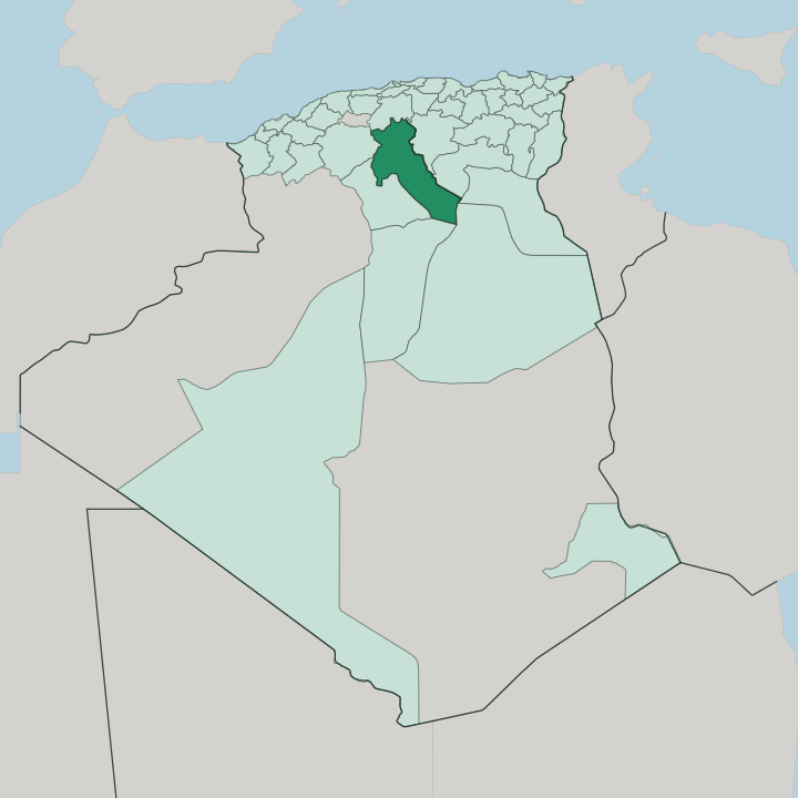


Towns & cities in Wilaya de Djelfa
Pick a town or city — each links to where to stay.
Djelfa, the provincial capital, is the practical base and the one town with a proper cluster of hotels. It sits on the N1 highway between the coast and the desert, close to the Sénalba pine forest and the eroded salt outcrop called Rocher de Sel. South toward the Sahara, Messaâd holds the steppe where Ouled Naïl herders still winter their flocks.
Rooms elsewhere are mostly roadside inns. Pick the capital for the livestock market and forest walks; carry on to Messaâd for the open desert edge.
About Wilaya de Djelfa
What is Wilaya de Djelfa known for?
Djelfa is Algeria's sheep country. The provincial capital, also called Djelfa, runs one of the country's largest livestock markets, where herders of the Ouled Naïl confederation bring flocks down from the surrounding steppe. Above the town, the Sénalba pine forest holds the last stands of Aleppo pine before the ground turns to desert.
Prehistoric hunters left rock engravings across the Ouled Naïl Range, and semi-nomadic families pitch black tents on the high plateau each season.
Where is Wilaya de Djelfa?
Wilaya de Djelfa sits on the high steppe of north-central Algeria, one of the country's larger provinces at 66,415 square kilometres. The land is a threshold. To the north lie the Hautes Plaines, the treeless high plateaus dotted with chotts, the shallow salt flats that flash white after rain and dry to crust in summer.
Through the middle run the parallel limestone ridges of the Ouled Naïl Range, the southernmost reach of the Saharan Atlas, and south of them the ground tilts down toward the Sahara. The provincial capital, Djelfa, stands among these ridges at around 1,100 metres, on the old caravan line between Bou Saâda to the north-east and Laghouat to the south. Just west of the town, the Sénalba pine forest covers roughly 19,500 hectares of Aleppo pine, green oak, and juniper, the last real woodland before the desert.
North of Djelfa, wind and rain have carved the Rocher de Sel, a hill of exposed rock salt and marl. Rivers here are wadis, dry beds that fill only after a storm. Grazing land dominates everything else.
Wide and open, the steppe carries the sheep flocks that give the province its living, thinning gradually into scrub and stone as the Sahara takes over in the south.
What is Wilaya de Djelfa like?
Life here runs on the flock. The Ouled Naïl, an Arab confederation that traces its descent to Sidi Naïl, a sixteenth-century holy man and sharif, gave the range and the province their name, and their calendar still follows the sheep between winter pasture and summer grazing. Wool is the material of daily life.
Families weave the long striped tents they live in, and Ouled Naïl silverwork, heavy coined necklaces and enamelled brooches, once travelled across the whole of Algeria. Arabic is the common tongue. The old souk at Djelfa remains a livestock town's souk, loud on market day with sheep, saddlery, and dates carted up from the oases to the south.
Deep time is written on the rock. Across the Ouled Naïl Range, Neolithic hunters pecked engravings of elephants, ostriches, and wild cattle into cliff faces, a record of a wetter Sahara long before the sand. Poetry and religious festivals mark the pastoral year, held at the tombs of local marabouts.
Not much of this reaches the outside traveller. The province keeps a working, herding character, closer to the tent and the market than to any monument, and that plainness is its texture.
What is the history of Wilaya de Djelfa?
A Roman town called Fallaba once stood on the site of Djelfa, a minor bishopric on the desert frontier of Numidia. It faded with late antiquity. Centuries later the Ouled Naïl settled the range, following Sidi Naïl out of the north, and the plateau became sheep and caravan country linking the Tell to the Sahara.
The modern town is young. French troops laid it out in 1852 as a military post on a strict geometric plan, at the junction of the routes south. During the Second World War a Vichy internment camp held political prisoners and refugees on the cold steppe outside the town.
What is the climate of Wilaya de Djelfa?
Up on the Ouled Naïl steppe, height dictates Djelfa's climate. On the high steppe of the Ouled Naïl Range, Djelfa has a cold semi-arid climate, more continental than the Mediterranean coast to the north. Winters bite.
Snow settles on the ridges and the Sénalba pines from late autumn into spring. Summer turns hot and dry, but the plateau's height blunts the worst desert heat. Most rain falls between autumn and spring, filling the wadis in brief flood before they run dry again.
Day gives way to cold night quickly out on the open plateau.
How do you get to Wilaya de Djelfa?
Most travellers come overland from Algiers. The capital is the country's main entry point, and the N1 trunk road runs south from it across the plateau, passing straight through Djelfa toward Laghouat and the deep Sahara. A single-track railway shadows the same corridor, linking Boughezoul, Djelfa, and Laghouat.
From the east, the N46 climbs in from Bou Saâda. Buses and shared taxis cover the roads. The drive up from the coast takes the better part of a day.
Good for
Updated July 2026