Algeria
Wilaya de Tlemcen, Algeria — Towns & Travel Guide


Wilaya de Tlemcen is a province in the far north-west of Algeria, its Zayyanid capital rising in the Tell Atlas above the Mediterranean coast.
About Wilaya de Tlemcen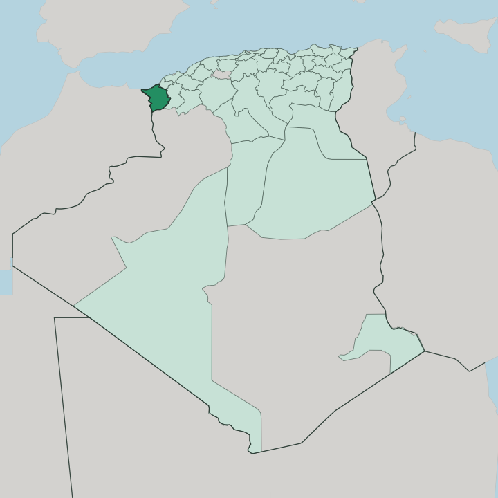


Towns & cities in Wilaya de Tlemcen
Pick a town or city — each links to where to stay.
Most travellers base themselves in Tlemcen, the provincial capital set high in the mountains near El Mechouar Palace and the Great Mosque of Tlemcen. It puts the medina, the museums and the cable car to the Lalla Setti plateau within reach. The coast is a province apart.
Ghazaouet is the working port of the Trara shore, and inland Nedroma keeps its Almohad walls and a living Gharnati tradition. Choose the city for monuments; choose the Trara for the sea.
About Wilaya de Tlemcen
What is Wilaya de Tlemcen known for?
Tlemcen is Algeria's capital of Andalusi art. The province carries the memory of the Zayyanid dynasty, whose Kingdom of Tlemcen ruled the central Maghreb from the walled city for more than three centuries. Its signature is architecture: the Almoravid Great Mosque of Tlemcen, the Marinid minaret at Mansourah, and the tomb of Sidi Boumediene above the old town.
Gharnati, the Andalusian classical music brought by refugees from Granada, is still sung here. Mountains, coast and medieval stone sit close together.
Where is Wilaya de Tlemcen?
Wilaya de Tlemcen sits in the far north-west of Algeria, pressed against the Moroccan border and the Mediterranean Sea. Its western edge runs along the frontier with Morocco, from the coastal crossing at Marsa Ben M'Hidi down through the plains around Maghnia. To the north the province meets the sea along the Trara coast, a rocky shore of small ports like Ghazaouet and Honaine.
The land climbs steeply from there. The Tlemcen Mountains, the western end of the Tell Atlas, wall off the coast from the interior and lift the provincial capital onto a limestone shelf above the plain. Water defines the middle of the province.
The Tafna rises in these mountains and cuts north-west across the province to reach the Mediterranean near Béni Saf, gathering the streams that water the Tlemcen basin. South of the ridgeline the country changes character again, dropping toward the dry high plains that run on toward the Sahara. Cedar and pine crown the Tlemcen National Park. Aïn Témouchent and Sidi Bel Abbès border the province to the east, with Naâma spread across the dry south.
It is a province stacked in bands, from salt water to steppe in the space of a short drive.
What is Wilaya de Tlemcen like?
Tlemcen calls itself the capital of Andalusi art in Algeria, and the claim rests on real inheritance. Families who fled the fall of Muslim Granada carried their music, crafts and building styles across the sea, and the province absorbed them into an older Berber base. That fusion still sounds in Gharnati, the Andalusian classical song carried from Granada and kept alive in the medersas and conservatories of the old city.
Zenata Berber, Arab, Andalusi and Ottoman layers all show in the plasterwork, the calligraphy and the tilework of the monuments. The blending itself is what matters here. Faith shaped the place as much as art did.
The Sufi master Abu Madyan, known here as Sidi Boumediene, drew scholars and pilgrims to his shrine at El Eubbad, and Ibn Khaldun once taught in its madrasa. Craft traditions run alongside the devotion. Nedroma and the old quarters of Tlemcen still turn out hammered copperwork, woven haïks and worked leather.
The everyday language is Algerian Arabic, threaded with Berber of the Zenata and with French from the colonial century. Poetry, prayer and song hold the whole thing together.
What is the history of Wilaya de Tlemcen?
Long before the medina, a Roman garrison called Pomaria held the site. Tlemcen's greatness came with the Berbers: the Almoravids raised the Great Mosque, and after the Almohad collapse the Zayyanid dynasty made the city the seat of an independent Kingdom of Tlemcen in 1235. Scholars filled its madrasas.
For three centuries it commanded the caravan routes between Morocco and Ifriqiya. The Marinids of Fez besieged it and built the rival town of Mansourah outside the walls, only for the Zayyanids to raze it once they withdrew. Ottoman rule closed the kingdom's book in the 1550s.
What is the climate of Wilaya de Tlemcen?
The province has a Mediterranean climate that turns drier and cooler with height. On the Trara coast winters stay mild and summers warm. Up in the Tlemcen Mountains, where the capital sits on its high shelf, the air is fresher and rain is heavier.
Snow whitens the plateau in cold months. Most of the year's rain falls between autumn and spring, feeding the Tafna and the springs that gave the city its Berber name. Across Tlemcen the summer months turn hot and rainless.
South toward Naâma the land shades into steppe, where the Mediterranean influence gives way to the edge of the Sahara.
How do you get to Wilaya de Tlemcen?
Most visitors arrive by air at Zenata Airport, on the plain north-west of the city and named for the Tlemcen nationalist Messali Hadj. Its flights reach Algiers and the Algerian communities in France. The bigger hub at Oran lies a couple of hours east by road or rail, and most long-haul arrivals still route through there.
Overland the Moroccan frontier runs close, though the crossing near Maghnia has long been shut. The port at Ghazaouet still handles freight and a seasonal car ferry across the Mediterranean to Spain. The last climb is short.
Good for
Updated July 2026