Algeria
Wilaya de Sétif, Algeria — Towns & Travel Guide


Sétif is a province on the High Plateaus of north-eastern Algeria, known for the Roman ruins of Djémila and snowy Berber highlands.
About Wilaya de Sétif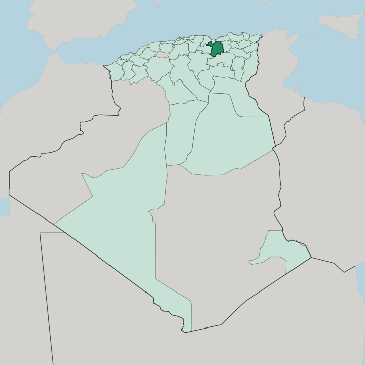


Towns & cities in Wilaya de Sétif
Pick a town or city — each links to where to stay.
Base yourself in the city of Sétif. The provincial capital holds the province's fullest run of hotels, most within walking distance of the Aïn Fouara fountain and the Park Mall. El Eulma, the trading town east across the plain, adds rooms near its wholesale souk.
For the Roman ruins, a handful of small guesthouses sit beside Djémila itself, best booked ahead. Up in the Babor mountains around Bougaâ, where the roads climb into cedar forest, the lodging thins to the simple kind. Start with the city of Sétif.
About Wilaya de Sétif
What is Wilaya de Sétif known for?
Two things draw travellers to Sétif: Roman stone and cold mountain air. The best-preserved Roman city in the region, Djémila, stands on a ridge north of the provincial capital, its forum and triumphal arch listed by UNESCO. The capital itself, also called Sétif, centres on the Aïn Fouara fountain and a Byzantine citadel.
Higher up lies the Babor massif, where cedar forest and Barbary macaques hold out above the wheat plains of the High Plateaus. Snow settles here.
Where is Wilaya de Sétif?
Sétif sits on the eastern High Plateaus of north-eastern Algeria, a belt of open steppe and grain plain more than a thousand metres up. It is inland country. Nothing here touches the sea.
The Tell Atlas rises along the northern edge of the province, its ridges folding down toward the Mediterranean coast that the province never quite reaches, while the ground falls away southward toward the salt depression of the Hodna and the Aurès beyond. Between those walls lies the tableland where most people live. The provincial capital, Sétif, and its neighbour El Eulma stand out on this plain, linked by the east-west highway and the wheat that surrounds them.
Water is scarce and precious. The Bou Sellam River gathers the plateau's run-off and slips west past the capital, on its way to join the Soummam that reaches the sea at Béjaïa. In the far north the land bucks upward again into the Babor Mountains, part of the Tell Atlas, where Djebel Babor climbs to just over two thousand metres and holds snow and cedar long after the plain has dried.
That vertical range, from steppe floor to forested summit, is what defines the province.
What is Wilaya de Sétif like?
Sétif is Algerian to the core, and its social life runs on Arabic, but the province keeps a strong Berber grain underneath. In the plains and towns most people speak Algerian Arabic. Up in the mountains that thread toward Kabylie and the Aurès, older Amazigh tongues hold on: Kabyle in the northern hills, the Chaoui variety of Tamazight among families with roots in the Aurès to the south.
Yennayer, the Amazigh new year, is marked here in January with couscous and family gatherings. That older identity is a source of quiet pride. Daily life gathers around the Aïn Fouara fountain in the heart of the capital, a nineteenth-century basin crowned by a marble statue that Sétifiens treat as their emblem.
Commerce is the other pulse. El Eulma's wholesale market is a byword across Algeria for cheap goods hauled in by the container-load, and its traders supply markets the length of the country. The past presses close too.
Djémila's Roman streets and mosaics sit a short drive north, and the memory of the 8 May 1945 killings, which began with a march through Sétif, is woven into how the province understands itself. Grief and pride live side by side.
What is the history of Wilaya de Sétif?
The name Sétif descends from Roman Sitifis, a colony of veterans planted under the emperor Nerva around the year 97. Its bones are Roman. By the late third century the town was capital of Mauretania Sitifensis, and nearby Cuicul, now Djémila, prospered on grain and olive oil.
Rome gave way to Byzantines, then to Arab and Berber dynasties, and much later to French rule after 1830. On 8 May 1945 a victory-day march through Sétif was fired on, and the killing that followed across the region helped push Algeria toward independence.
What is the climate of Wilaya de Sétif?
Height rules the weather here. Sétif sits over a thousand metres up, so its winters bite in a way the Algerian coast never knows: frost, grey skies, and snow that closes mountain roads for days. Summers swing the other way, hot and dry and dusty, the wheat plains bleaching gold by July.
Rain mostly comes in spring and autumn. The Babor Mountains in the north wring far more of it from the sky, piling up deep snow that feeds the springs below long into the dry season.
How do you get to Wilaya de Sétif?
Most travellers reach Sétif by road. Sétif lies on the trunk road and rail line that run east to Constantine and west to Algiers, and the trans-national East-West Highway crosses the whole province. For flying, the 8 May 1945 Airport at Aïn Arnat, just west of the capital, handles domestic hops from Algiers and a scatter of international routes.
Trains stop at Sétif and El Eulma. From the coast at Béjaïa, the mountain road climbs up through the Kabyle hills to reach the plateau.
Good for
Updated July 2026