Algeria
Wilaya de Tizi Ouzou, Algeria — Towns & Travel Guide


Wilaya de Tizi Ouzou is the Kabyle heart of Algeria, running from the Djurdjura crest down the Sebaou valley to an 85-kilometre Mediterranean coast.
About Wilaya de Tizi Ouzou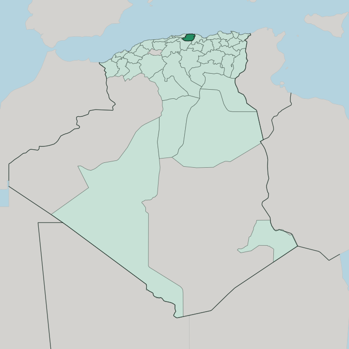


Towns & cities in Wilaya de Tizi Ouzou
Pick a town or city — each links to where to stay.
The city of Tizi Ouzou is the practical base, set in the Sebaou valley where the roads and railway from Algiers arrive. For the coast, Tigzirt and Azeffoun face the Mediterranean at opposite ends of the shore, one built beside Roman ruins, the other a fishing port on Cape Corbelin. For the mountains and the crafts, Aït Yenni sits high on a Djurdjura ridge among its silversmiths.
Choose by altitude. Sea, valley, or summit are an hour or two apart.
About Wilaya de Tizi Ouzou
Tizi Ouzou is the cultural capital of Kabylia.
What is Wilaya de Tizi Ouzou known for?
The Djurdjura range walls the southern edge, its crest crowned by Lalla Khedidja, while the Sebaou River drains the central valley north to a short Mediterranean coast at Tigzirt and Azeffoun. Villages cling to the ridges. Aït Yenni works silver and red coral into the enamelled jewellery the province is known for, and the mountain slopes carry olive groves, fig orchards, and cork oak.
The city lit the Berber Spring.
Where is Wilaya de Tizi Ouzou?
Wilaya de Tizi Ouzou occupies the core of Greater Kabylia, in the mountainous north of Algeria roughly a hundred kilometres east of Algiers. The Mediterranean forms its whole northern edge, about 85 kilometres of cliff and cove broken by the beaches at Tigzirt and Azeffoun. Boumerdès lies to the west, Béjaïa to the east, and Bouira over the mountains to the south. Inland the land climbs fast.
From the shoreline it rises through wooded hills to the Djurdjura, the limestone wall of the Tell Atlas that seals the province off along its southern rim and carries the snows of Lalla Khedidja. The Sebaou River is the artery of all this. It gathers in the eastern mountains, runs the length of a broad central valley past the capital, and empties into the sea near the Boumerdès line.
Ridge-top villages watch the water from both sides. Between the coast and the crest the province stacks its country in bands, beach and headland along the shore, the fertile Sebaou trench through the middle, and the high Djurdjura pastures and cedar forest above. Little of it is flat.
Elevations run from sea level to well over two thousand metres in a single province, and that vertical reach is what gives Tizi Ouzou its character.
What is Wilaya de Tizi Ouzou like?
This is Kabyle country before it is anything else. The people are Amazigh, and the language of the streets and the villages is Kabyle, the most widely spoken Berber tongue in Algeria; Arabic and French are heard alongside it. Villages sit high and tight on the ridges, stone houses under red tile, wrapped around a mosque and a village assembly that still settles local affairs.
Olives are the year's clock. The autumn harvest and the winter pressing of oil, the fig drying, the terraced gardens, all of it ties Kabyle identity to a hard and generous land. The province is famous for what its hands make.
Aït Yenni works silver into fibulae and pendants set with red coral and bright enamel, a craft carried on there when it died out almost everywhere else, and the village holds a jewellery fair each summer. Potters shape the clay of Mâatkas, and weavers knot Berber wool. Song matters as much as silver.
Kabylia gave Algeria some of its best-loved singers and poets, from Idir to Lounès Matoub and Aït Menguellet, their verses sung in Kabyle. The city of Tizi Ouzou is the intellectual centre of it, seat of Mouloud Mammeri University and the place where the Berber Spring began. Pride runs stubborn here.
What is the history of Wilaya de Tizi Ouzou?
The name is Kabyle: Tizi Ouzou, the pass of the broom. Long before the French came, the Djurdjura sheltered the Kingdom of Kuku, a Kabyle state that held out against the Regency of Algiers from its mountain seat. France took the highlands only in 1857.
The garrison town below the crest dates from that campaign, and the great Mokrani revolt broke here and across Kabylia soon after, in 1871. The province is smaller than it once was, and in 1984 its western districts were carved off to form Boumerdès.
What is the climate of Wilaya de Tizi Ouzou?
Tizi Ouzou has a Mediterranean climate that the mountains pull two ways. Down on the coast and in the Sebaou valley, summers are hot and dry and winters mild and wet, with the heavy rain falling between autumn and spring. Altitude reshapes the whole picture in Tizi Ouzou.
Snow settles on the Djurdjura from December into March, sometimes deep enough to close the high passes, and even the valley towns see the odd white morning. The coast stays the gentlest corner. Spring, when the peaks are still capped and the slopes green, is the province at its best.
How do you get to Wilaya de Tizi Ouzou?
No airport serves the province itself. The usual approach is through Algiers, whose Houari Boumediene Airport lies about a hundred kilometres to the west, from where the national road runs east along the coast and up the Sebaou into the city of Tizi Ouzou. Trains follow the same valley.
Buses and shared taxis climb from the capital into Kabylia all day, thinning to winding mountain lanes as they near the high villages. Béjaïa, over the eastern border, gives a second airport within reach.
Good for
Updated July 2026