Algeria
Wilaya de Blida, Algeria — Towns & Travel Guide


Wilaya de Blida spreads across the Mitidja plain below the Tell Atlas, southwest of Algiers, Chréa's cedar forests and the City of Roses.
About Wilaya de Blida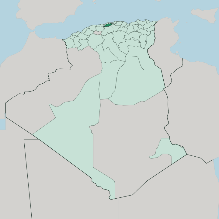


Towns & cities in Wilaya de Blida
Pick a town or city — each links to where to stay.
Blida town is the obvious base, capital of the province and closest to both the plain and the mountains. Most of the province's rooms gather in Blida itself. For cool air and cedar forest, climb to Chréa, the hill station and ski village set high in the Blidean Atlas above the Chiffa gorge.
Boufarik sits out among the orange orchards of the Mitidja plain, a working market town rather than a resort. Hammam Melouane, tucked into the southern hills, trades on its hot mineral springs. Pick Blida for a first stay.
Head up to Chréa when you want the forest and the snow.
About Wilaya de Blida
What is Wilaya de Blida known for?
Two things carry the province's name: fruit and flowers. Blida, the capital, is nicknamed the City of Roses for the gardens that scent its streets, while Boufarik out on the Mitidja plain built its fortune on oranges and the sweet orangeade pressed from them. Above the plain rises Chréa, where cedar forests shelter Barbary macaques and one of Africa's few natural-snow ski runs draws weekend skiers from Algiers.
The Chiffa gorge cuts a dramatic road south through the same mountains. Farmland and forest, side by side.
Where is Wilaya de Blida?
Wilaya de Blida lies in northern Algeria, a short drive southwest of the capital at Algiers. The province is small. Its geography reads at a glance: the flat, fertile Mitidja plain fills the north, while the wall of the Tell Atlas rises abruptly along the south and the provincial capital of Blida sits on the seam between them.
From the plain the ground climbs fast into the Blidean Atlas, the local name for this stretch of the range. The mountains hold the province's wildest ground. Chréa National Park spreads across the heights, its slopes dark with Atlas cedar and roamed by the Barbary macaque.
Winter dusts the higher cedars with snow. The Chiffa gorge slices through the range south of the capital, carrying the road and the Oued Sidi el Kebir down from the high country. Water off these peaks feeds the orchards below, and the Mitidja plain grew into some of the richest farmland in the country.
Algiers and the Mediterranean coast lie just to the north, close enough that Blida works easily as a day trip out of the capital. Everything here follows that one edge.
What is Wilaya de Blida like?
Blida wears its Andalusian roots openly. The capital was founded in the sixteenth century by Sidi Ahmed El Kebir, who settled Moorish refugees expelled from Spain, and their gardens and irrigation channels shaped the town that grew here. Roses became the emblem.
Blida is still called the City of Roses for the flowers grown in its walled courtyards and sold in its markets. Layers of later rule sit on top of that founding, Ottoman mosques, then the arcaded squares and straight streets the French laid out after the earthquake of 1825 flattened the old town. The plain has deeper roots too.
Berber communities known as the Djebailia have farmed the Mitidja plain for centuries, on the land long before the Andalusian settlers ever arrived. Boufarik turns its citrus harvest into a yearly festival, and the orangeade first bottled there is drunk across the country. Weekends pull families the other way, up to Chréa, where snow and cedar forest sit an hour above the orange groves and the heat of the plain.
The scent of orange blossom carries for miles across the plain each spring.
What is the history of Wilaya de Blida?
The province takes its name and its story from Blida. Moorish exiles from Andalusia founded the town in the sixteenth century, planting the orchards and rose gardens that still define it. An earthquake levelled it in 1825, and the survivors rebuilt on a grid a short way off.
French troops marched in during 1839 and turned Blida into a garrison, ringing it with barracks and a military airfield on the plain. The modern wilaya was drawn later, in 1974, carved from the old department around Algiers. Farmland, faith and forts.
What is the climate of Wilaya de Blida?
Blida has a Mediterranean climate, split sharply by elevation. Down on the Mitidja plain summers run hot and dry while winters stay mild and wet, and most of the year's rain falls between autumn and spring. Up in the Blidean Atlas the pattern flips cooler and wetter.
Snow settles on Chréa through winter, enough to keep its ski slopes working when the plain below never freezes. The orange blossom opens in spring.
How do you get to Wilaya de Blida?
Almost every trip starts in Algiers. The nearest airport is Houari Boumediene, out on the coast east of the capital, and Blida sits under an hour's drive south from there. Trains run the short line down from Algiers across the Mitidja plain to Blida and on to Boufarik.
Drivers take the motorway south, then the old road that threads the Chiffa gorge if they are climbing to Chréa. It is an easy hop from the capital.
Good for
Updated July 2026