Algeria
Wilaya de Mostaganem, Algeria — Towns & Travel Guide


Wilaya de Mostaganem is a coastal province of north-western Algeria, strung along the Mediterranean where the Chelif River reaches the sea.
About Wilaya de Mostaganem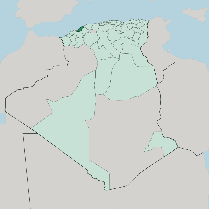


Towns & cities in Wilaya de Mostaganem
Pick a town or city — each links to where to stay.
Base yourself in Mostaganem for a first visit; the province spreads out from there. The port anchors the capital. South of it, the Salamandre corniche packs the summer beach crowd along the sands of Sablettes and Salamandre, while the wilder Dahra coast north-east toward Cap Ivi keeps its coves quiet and its hotels few.
Inland, the Mostaganem Plateau rolls out in citrus groves and market gardens around the town of Aïn Tédelès. Choose the corniche for the sea and the old town for the harbour and the medina.
About Wilaya de Mostaganem
What is Wilaya de Mostaganem known for?
Mostaganem is a Mediterranean port and beach province, and the coast is its calling card. Sand runs for kilometres. Holidaymakers from Oran and inland Algeria fill the resorts of Salamandre and Sablettes through the summer, drawn by the fishing harbour, the seafront corniche, and the whitewashed lanes of the old Tijditt quarter above the town.
The province also carries a strong cultural name: it is a centre of Andalusian and Hawzi music, a cradle of modern Algerian theatre, and a historic seat of the Alawiyya Sufi order.
Where is Wilaya de Mostaganem?
Mostaganem sits on the Mediterranean coast of north-western Algeria, about eighty kilometres east of Oran. Its shore curves along the Gulf of Arzew and runs on past the port city for well over a hundred kilometres of cliffs, coves, and sand. The Mediterranean forms the whole northern edge.
Inland, the province borders Oran and Mascara to the west, Mascara and Relizane to the south, and Chlef and Relizane to the east. It is compact by Algerian standards, a coastal wilaya rather than a Saharan one. The land climbs and folds inland into four distinct parts.
The Dahra Range, a low chain of the Tell Atlas, runs down the coast from the east and ends near the mouth of the Chelif River, which is the longest river in Algeria and empties into the sea just north of Mostaganem town. South of the hills the ground opens into the Mostaganem Plateau, a broad tableland of red farming soils. The Chelif valley threads between the two.
Toward the south-western corner the plateau falls away to low plains beside the Macta marshes, where the province gives onto the wetlands shared with Oran and Mascara. Sea, hill, plateau, and marsh sit within an easy drive of one another.
What is Wilaya de Mostaganem like?
Culture in Mostaganem leans on music, faith, and the stage. Andalusian classical music and its lighter Hawzi offshoot, carried west by refugees from Al-Andalus, are still taught in the town's conservatories and played at weddings. The province is also a heartland of Algerian Sufism: the Alawiyya order was founded here in the early twentieth century by Sheikh Ahmad al-Alawi, and its zawiya still draws followers from across the Muslim world.
Theatre matters as much as either. Mostaganem is widely called the cradle of modern Algerian drama, the home town of the playwright Ould Abderrahmane Kaki, and the host of a long-running national festival of amateur theatre. Everyday life still centres on the old quarter.
Tijditt climbs the slope above the Aïn Sefra ravine in tight lanes of whitewashed, blue-shuttered houses, the Andalusian pattern the returning refugees brought with them. Beyond the town the land is farmed hard. Colonial vineyards on the Mostaganem Plateau gave way after independence to citrus orchards, cereals, and market gardens, and the region's oranges, olives, and figs still fill the markets.
Arabic is the everyday language, in its western Algerian dialect. The University of Abdelhamid Ibn Badis fills the town with students and keeps the old music and letters in circulation.
What is the history of Wilaya de Mostaganem?
Mostaganem grew up as a walled port in the eleventh century. The Almoravids raised its Bordj el-Mehal citadel above the harbour in 1082, and the town later served as a port of the Zayyanid and Marinid kingdoms. Ottoman rule followed in the sixteenth century.
They made it a corsair base and trading port facing the Spanish across the western Mediterranean, until France landed a garrison in 1833 and held the region through to Algerian independence in 1962. In 1984 the neighbouring wilaya of Relizane was split from its eastern half.
What is the climate of Wilaya de Mostaganem?
Mostaganem has a hot-summer Mediterranean climate. Summers are long, dry, and hot, cooled on the coast by sea breezes off the Gulf of Arzew but far harsher inland when the chergui blows up from the Sahara. Around Mostaganem the cold season stays soft and damp.
Almost all the rain falls between October and March, and the yearly total stays modest, near 350 mm along the shore and thinner still on the Mostaganem Plateau, which the Dahra Range shelters from the rain. The sea keeps the coast greener than the semi-arid interior.
How do you get to Wilaya de Mostaganem?
Mostaganem has no airport of its own. The nearest is Oran's Ahmed Ben Bella airport, roughly eighty kilometres west, from which the coast road runs in along the shore within about an hour. Ferries also call at the town's own port in the centre, crossing the Mediterranean, so some travellers arrive by sea instead.
On land the national roads carry the traffic: the N11 follows the shore in from Oran, while the N4 and N90 climb inland toward Relizane and Mascara before dropping back to the coast. From the capital those same roads fan out to the beaches, the plateau, and the Chelif valley.
Good for
Updated July 2026