Algeria
Wilaya de Saïda, Algeria — Towns & Travel Guide


A spring-fed province on Algeria's western High Plateaus, Wilaya de Saïda lifts wooded hills above the alfa steppe below the Tell Atlas.
About Wilaya de Saïda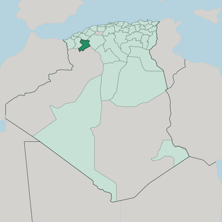


Towns & cities in Wilaya de Saïda
Pick a town or city — each links to where to stay.
Almost every hotel is in Saïda itself. The provincial capital holds nearly all of the province's beds, strung along the Oued Saïda and the avenues that climb from the river toward the old French-built quarter. Outside it, the daïra towns run to guesthouses and roadside auberges rather than hotels.
Base yourself in Saïda for the springs and the forests, and drive out to Aïn El Hadjar or the Monts de Saïda by day. The town is the natural base.
About Wilaya de Saïda
Saïda answers to a nickname, the ville des eaux.
What is Wilaya de Saïda known for?
Springs surface across the province. The Oued Saïda rises in the hills to the south and runs clear through the valley beneath the town even through the hottest weeks of the Algerian summer. Two springs carry the reputation, Aïn Zerga and Aïn Sidi Ahmed, both prized for mineral water long taken as a cure.
Aleppo pine and holm oak darken the ridges around it. Wool, cereals, and bottled water leave the province, while Sufi zaouias still draw pilgrims to the town.
Where is Wilaya de Saïda?
Saïda sits inland and high. The province occupies part of Algeria's western High Plateaus, the belt of alfa steppe that runs between the Tell Atlas in the north and the Saharan Atlas away to the south. It stands well back from the Mediterranean coast, a long day's drive from the port of Oran to the northwest.
Mascara lies over the hills to the north, the desert further south. Saïda has long been read as a threshold, the point where the settled north gives way to the plateaus and the desert beyond. Two ranges frame the town.
The Monts de Saïda rise to the east toward Frenda, the Monts de Daïa to the west, both wooded above the open plains. Between them the land drops into the valley the Oued Saïda has cut through the plateau. That river never runs dry.
Its source lies in the hills a short way south of the town, at roughly 1,200 metres, and the water holds even through the fierce heat of the plateau summer. Springs rise all through these hills. They gave Saïda its old name, the ville des eaux, and they still feed the wells and bathhouses of the valley.
What is Wilaya de Saïda like?
Sufi orders shape religious life here. The province's zaouias, the lodges of the Sufi brotherhoods, still draw pilgrims for the yearly waâda gatherings, and the Tijaniyya order keeps a strong following across the plateau towns. Out on the open steppe, daily life turns on sheep and wool and the alfa grass that carpets the high plains between the ranges.
Herders have worked these plains for generations. Fantasia horsemen and harvest waâdas still mark the season in the villages around Saïda. The town itself feels French-planned.
Saïda grew up around a nineteenth-century French military post and once garrisoned the Foreign Legion, and its grid of straight avenues and open squares still carries that colonial stamp. Arabic is the everyday language, with Berber speech and French both still heard. Leather and craftwork trade in the covered markets.
Water threads through everything. The springs feed the public baths and hammams, and the bottled mineral water of Saïda carries the province's name to tables far beyond the plateau. Esparto from the alfa steppe has long been woven into mats and baskets across the plateau villages.
What is the history of Wilaya de Saïda?
The site has always guarded a crossing. A Roman fort once stood here, and the town later became a stronghold of Emir Abdelkader, who burned it himself as French columns closed in during 1844. France rebuilt Saïda as a military outpost in 1854 and garrisoned the Foreign Legion there.
The narrow-gauge railway from Oran arrived in 1862, bound south for Béchar. The wilaya came later. Algeria drew the province in 1974 from the old Oran department, and El Bayadh and Naâma were split from its southern reaches a decade on.
What is the climate of Wilaya de Saïda?
Height tempers the heat here. The province sits high enough on the plateau that its summers, though hot and bone-dry, stay a shade cooler than the coast, while winters turn genuinely cold at night. Rain falls mostly in autumn and winter, a little over 300 millimetres in a year.
Snow dusts the higher ridges of the Monts de Saïda. South of the town the rainfall thins fast, and near the alfa steppe the land shades from dry farming into open pasture. The springs beneath Saïda run on regardless, fed from deeper underground than any single dry summer can reach.
How do you get to Wilaya de Saïda?
No coast, no ferries. Most travellers reach the province overland from Oran, whose airport on the coast to the northwest is the nearest big one, a half-day's drive inland across the plateau hills. The road climbs from Oran through Mascara before it drops toward Saïda.
A railway still runs through the town as well, the old narrow-gauge line linking Oran with Béchar out in the southwest. From there the desert opens south. Buses and shared taxis knit the daïra towns of the province to the capital at Saïda.
Updated July 2026