Where to stay in Utsjoki
The right area depends on your trip. Here's who each one suits — pick the place, then the hotel.
Utsjoki holds most of its beds in fishing lodges, cabins and small guest houses rather than hotels. The village by Utsjoen kirkko carries a few rooms and services, the main base in the far north, while cabins and lodges line the Teno river where the salmon draw anglers through the brief Arctic summer. Beds cluster by the water.
Many visitors stay at riverside lodges along the border with Norway, a quiet base for fishing and for touring the fells of Lapland in the long northern daylight. Away from the river, cottages and wilderness huts spread thinly across the fells and the road south toward Inari, a base for hikers and for travellers crossing the Arctic north by car. Beds all but vanish in winter.
The season here is short, the salmon rivers and the open road drawing visitors mainly in the summer months, when the long days fill the lodges of the Teno valley. Book the riverside cabins well ahead for the fishing season, when rooms in this remote corner of Lapland are few and quickly taken.
About Utsjoki
What is Utsjoki known for?
Utsjoki is the northernmost municipality of Finland, a Sámi parish on the Teno river in Lapland, in the Arctic north. It is known for its salmon fishing, its Sámi culture and the long border it shares with Norway along the river. The river rules life here.
Utsjoen kirkko stands above the water, the Välimaan tila open-air museum keeps the old Sámi farmstead, and the spring of Sulaojan lähde and the fells of this far corner draw travellers to the edge of Inari and the north.
What are the main landmarks in Utsjoki?
Utsjoen kirkko is the chief landmark of Utsjoki. The stone church stands above the Teno river with its old church cabins around it, the heart of the far-northern parish. The church marks the river.
Nearby the Utsjoen pappila preserves the old parsonage, the Välimaan tila keeps a Sámi farmstead as an open-air museum, and the spring of Sulaojan lähde rises among the fells of this corner of Lapland.
What is the history of Utsjoki?
Utsjoki has been Sámi land since long before the parish took shape. The people of the far north lived by reindeer, fishing and the river, and the Sámi settlement of the Teno valley left its mark across the fells in dwelling sites and farmsteads like the one kept at Välimaan tila. The river fed the people.
A church was raised above the water, and Utsjoen kirkko with its cluster of church cabins became the gathering place of the scattered parish in the Arctic north. The parish was set apart as its own municipality in 1876, the northernmost in the country, hard against the border with Norway. The old parsonage of Utsjoen pappila served the church through the long generations, and the salmon of the Teno drew people to the river season after season.
Fishing endured. Utsjoki kept its Sámi character and its remote life through the changes, a parish of fells, river and reindeer in this far corner of Lapland on the edge of Inari and the Arctic north.
Where is Utsjoki?
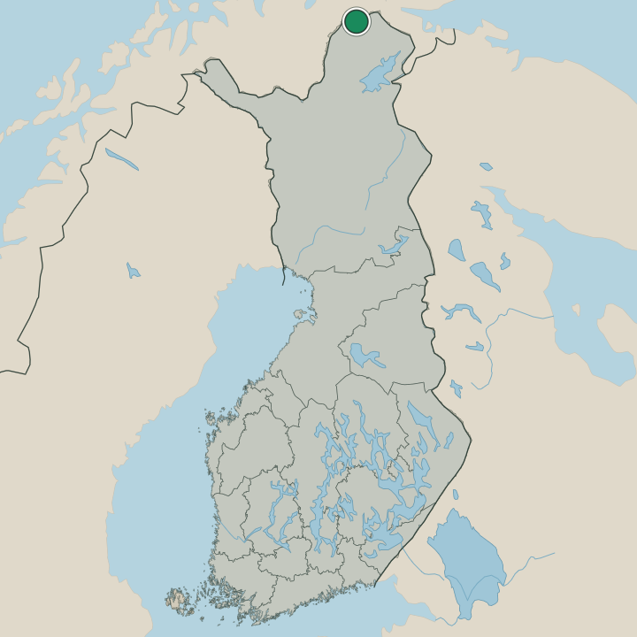
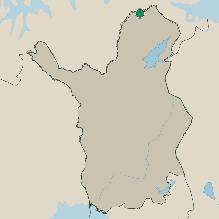
Utsjoki lies at the northernmost tip of Finland, in Lapland, in the Arctic north. The municipality spreads across open fells and tundra, the Teno river marking its long border with Norway as it runs to the Arctic Ocean. Fells fill the land.
The village gathers around Utsjoen kirkko on the riverbank, while the road south runs through the fells toward the neighbouring municipality of Inari, far from any large town in this remote corner of the north.
What is the climate of Utsjoki?
Utsjoki has a harsh subarctic climate at the northern edge of Lapland. Winters are long, dark and bitterly cold, the Teno river freezing hard and snow lying deep across the fells through months of polar night. Summers are brief and cool.
The midnight sun brings weeks of unbroken daylight to the river and the fells, a short, vivid season for the salmon and the hikers before the cold closes back over the Arctic north.
How do you get to Utsjoki?
Utsjoki is reached by the long road north. The main route runs up through Lapland past Inari to the village by Utsjoen kirkko, and a bridge crosses the Teno river into Norway at the border. The drive is long.
There is no rail this far north, so travellers fly to a Lapland airport further south and drive the rest, following the river and the fells to this northernmost corner of Finland.
Where Utsjoki sits
Boundaries © geoBoundaries (CC BY) & Wikidata (CC0); water & neighbours: Natural Earth.