Jordan
Irbid, Jordan — Towns & Travel Guide


Irbid is Jordan's green northern governorate, a plateau of olive groves and Roman ruins above the Yarmouk River.
About Irbid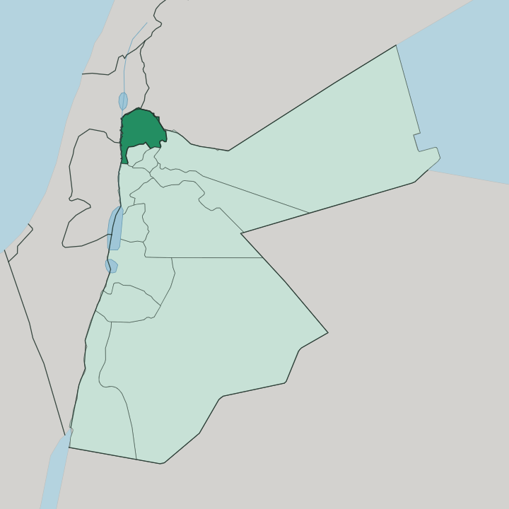
Towns & cities in Irbid
Pick a town or city — each links to where to stay.
Irbid city is the practical base, the one place in the governorate with a real spread of hotels and the students, cafés, and night bustle that come with four universities. The sights fan out. Umm Qais sits about an hour away on its hilltop over the Yarmouk gorge, worth a slow half-day for the ruins of Gadara and the long view toward the Jordan Valley.
Ar-Ramtha lies out east near the Syrian frontier, a working border town rather than a tourist stop. Base yourself in Irbid city for the university quarter and easy day trips; drive out to Umm Qais when you want the ancient stone and the valley below it.
About Irbid
Universities, olives, and ancient stone.
What is Irbid known for?
Irbid city anchors the governorate and ranks as one of Jordan's largest, built around Yarmouk University and often called the country's academic and cultural capital. The land around it is the most productive farming region in the kingdom, and its groves yield a large share of all Jordan's olives. Above the Yarmouk River in the north-west stands Umm Qais, the ruined Greco-Roman city of Gadara, once one of the ten cities of the Decapolis and now the governorate's most visited site.
Where is Irbid?
Irbid fills the far north-west corner of Jordan, roughly 88 km up the road from the capital at Amman. It is not a large governorate, but it holds a lot in a small compass. Most of it belongs to the Hauran, the volcanic basalt plateau that runs on north into south-western Syria, and the land here sits high and open at around 500 to 600 metres, tilted between low hills and wide farmed plains.
Water shapes the edges. The Yarmouk River cuts the northern boundary, dropping through a deep gorge that separates Jordan from the Golan Heights beyond, and the Jordan River marks the western limit where the plateau falls away into the Jordan Valley. Syria lies over the northern border and the Mafraq Governorate spreads out to the east, while Ajloun, Jerash, and Balqa press in from the south.
Springs rise across the plateau to feed the fields. That well-watered ground, unusual for this part of the region, is exactly what makes Irbid the greenest farmland in the country. The result is a compact northern province of olive terraces, wheat fields, and ancient hilltops set above two rivers.
What is Irbid like?
Irbid feels young. So much of it is students. Yarmouk University opened here in 1976 and pulled the whole city around it, joined since by more campuses until the streets filled with the cheap cafés, bookshops, and late arguments that follow a large student body.
People call Irbid the cultural capital of Jordan, and the claim rests on more than the lecture halls. Two of the country's better museums, the Museum of Jordanian Heritage and the Jordan Natural History Museum, sit on the Yarmouk University grounds. Arabic is the everyday language, spoken in the northern rural accent of the Hauran plateau.
Beyond the campuses, the older culture of the countryside still holds. Village life turns on the olive harvest, when families take to the terraces across the governorate to gather the crop that has fed this land since antiquity. Hospitality is close and unhurried, poured out over small cups of bitter coffee.
The mix is particular to this corner of the north: a farming province with a university city dropped into the middle of it, where lecture timetables and olive seasons run side by side.
What is the history of Irbid?
The site is very old. People have lived on the ground of Irbid city since the Early Bronze Age, more than five thousand years back. In classical times it was called Arabella, or Arbela.
Its greatest days came under Greek and Roman rule, when nearby Gadara, above the Yarmouk River, joined the Decapolis, the league of ten Hellenised cities on the empire's eastern frontier, and grew rich on trade and famous for its wine and its philosophers. The ancient town of Arabella now lies buried under the modern streets, but the ruins at Umm Qais still stand in the open to show what that age built.
What is the climate of Irbid?
Irbid has a Mediterranean climate, softer and wetter than the desert that fills most of Jordan. Summers run long, hot, and dry. Winters turn cool and rainy, and the high plateau catches a dusting of snow on a couple of days most years.
Rain falls almost entirely in the cooler months, enough across the season to water wheat and olives without irrigation, which is why the Hauran plateau farms green while the country to the south stays bare. The wet north is the exception here.
How do you get to Irbid?
Most travellers reach Irbid overland from Amman, about 88 km to the south, where Jordan's main international airport sits. The highway drive takes a little over an hour. From Irbid city the roads run out to the sights: north-west to Umm Qais above the Yarmouk River, and east to Ar-Ramtha on the Syrian border.
Buses run often. Frequent minibuses and shared taxis link the capital with Irbid, and a car makes the scattered ruins and villages far easier to reach.
Updated July 2026