Jordan
Muḩāfaz̧at Mādabā, Jordan — Towns & Travel Guide


Madaba Governorate spreads across a highland plateau south-west of Amman, its capital city famous for Byzantine mosaic floors.
About Muḩāfaz̧at Mādabā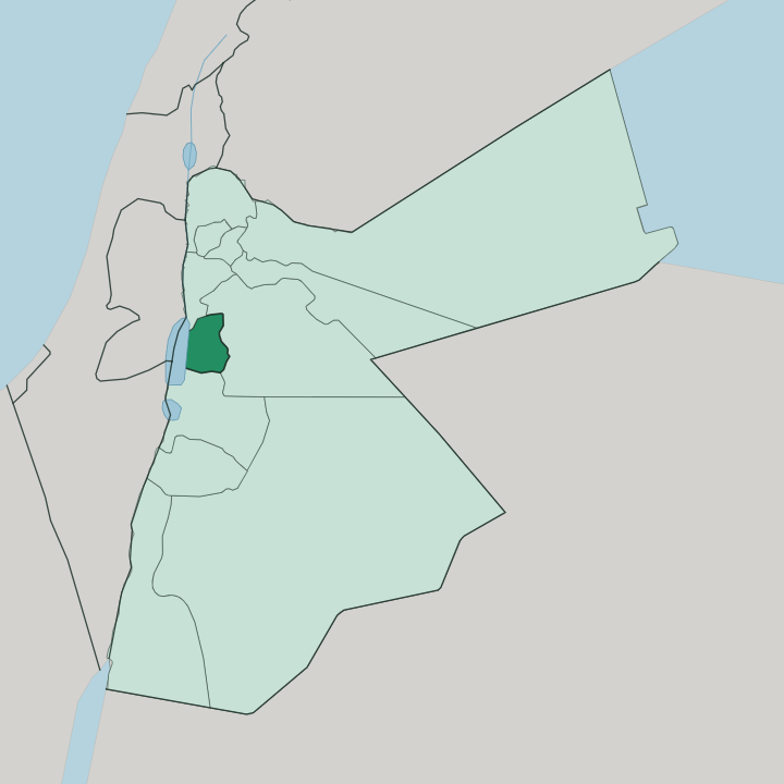
Towns & cities in Muḩāfaz̧at Mādabā
Pick a town or city — each links to where to stay.
Madaba is the natural base. Its small hotels and guesthouses cluster within a few streets of the Church of Saint George and its mosaic map, an easy town to walk. From there the rest of the governorate opens as day trips rather than overnight stops.
Mount Nebo sits a short drive west, the plateau rim above the Dead Sea, and the King's Highway runs south past Mukawir toward the canyon of Wadi Mujib. Stay in Madaba if you want to reach Queen Alia airport, the mosaics, and the Dead Sea shore all inside a half-hour to an hour. It suits you as a quieter first night in Jordan than Amman.
About Muḩāfaz̧at Mādabā
Mosaics made this place.
What is Muḩāfaz̧at Mādabā known for?
In the Greek Orthodox Church of Saint George in Madaba lies a sixth-century floor map of the Holy Land, laid between 542 and 570, that pictures Jerusalem and the lands from Lebanon to the Nile Delta in coloured stone. West of the town the ridge of Mount Nebo looks out over the Jordan Valley toward the Dead Sea, the summit where tradition says Moses saw the land he would never enter. The King's Highway threads south through the plateau past deep ravines.
Faith and stone hold the whole region together.
Where is Muḩāfaz̧at Mādabā?
Madaba Governorate lies in west-central Jordan, on a plateau south-west of Amman and its main city stands close to 800 metres above the sea. The land is high and open here. To the east the plateau rolls toward the desert; to the west it breaks apart, dropping through steep ridges toward the Jordan Valley and the shore of the Dead Sea far below.
Balqa Governorate borders it to the north and Karak to the south, while Amman lies just across the eastern edge. The governorate splits into two departments, the capital around Madaba in the north and Dhiban in the south, together holding more than seventy towns and villages across roughly 940 square kilometres. Water and rock carve the drama.
South of Dhiban the plateau is slashed open by Wadi Mujib, a canyon several hundred metres deep that drains west and empties into the Dead Sea, the biblical River Arnon that once marked the northern edge of Moab. West of Madaba the fortress hill of Mukawir, ancient Machaerus, rises on a stark promontory above the same descent, ringed by ravines on three sides. Between these cut edges the tableland stays broad and bare, ground the King's Highway has crossed since antiquity.
The whole region tips from high desert down to the lowest shore on earth.
What is Muḩāfaz̧at Mādabā like?
Madaba wears a Christian history rare in Jordan. The modern town was resettled in the 1880s by Arab Christian families who moved up from Al Karak to the south, and they cleared old church ground to build anew, uncovering Byzantine mosaic floors as they dug. That craft did not stay buried.
The town keeps a working mosaic school, and the church floors of Saint George and the Church of the Apostles remain the reason travellers turn off the highway. Arabic is the everyday language across the governorate, as everywhere in Jordan. Beyond the mosaics the culture is that of the Jordanian plateau.
Villages of the Dhiban department farm the tableland much as they have for generations, and the ruins scattered around them, Mukawir among them, tie the land to Moab, to Herod, and to the story of John the Baptist. Faith sits close to the surface here, Christian and Muslim alike, and pilgrims climbing Mount Nebo pass the same fields that feed the market in Madaba. It is a quieter, older Jordan than the capital an hour north.
What is the history of Muḩāfaz̧at Mādabā?
This ground is old. It belonged to the kingdom of Moab, whose King Mesha raised his inscribed victory stone at Dhiban, and later to Rome and Byzantium, when Madaba became a bishop's seat and its churches were paved with mosaic. The great map floor was set in the sixth century, between 542 and 570, before the town faded for centuries.
Madaba stood largely empty until the 1880s, when Arab Christian families from Al Karak resettled the ruins and rediscovered the buried mosaics beneath them. What Byzantium laid down, the nineteenth century brought back to light.
What is the climate of Muḩāfaz̧at Mādabā?
The plateau is dry. Its height near 800 metres tempers the heat that bakes the Dead Sea shore below, so Madaba runs cooler than the valley floor. Summers are hot and cloudless, the tableland baking under clear skies from spring through autumn, while winters turn mild and bring the season's brief rains and the odd cold snap to the high ground.
Little rain falls in any month. The western descent toward the Dead Sea grows hotter and harsher the lower the land drops.
How do you get to Muḩāfaz̧at Mādabā?
Queen Alia airport sits closer to Madaba than to Amman, so many travellers land and drive straight to the plateau within half an hour, skipping the capital altogether. From Madaba the King's Highway carries you south through the governorate past Mukawir toward the rim of Wadi Mujib, while a shorter road drops west to Mount Nebo and on down to the Dead Sea. Amman lies north.
Inside the region distances are short, and a car or a hired driver reaches everything comfortably in a single day.
Updated July 2026