Jordan
Al Mafraq, Jordan — Towns & Travel Guide


Al Mafraq is Jordan's north-eastern corner, where the Hauran plateau's black basalt gives way to the open Syrian Desert.
About Al Mafraq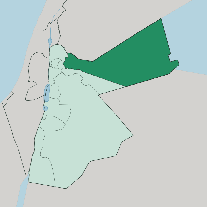
Towns & cities in Al Mafraq
Pick a town or city — each links to where to stay.
Al Mafraq keeps few beds for visitors. Mafraq city has a scattering of plain guesthouses near the crossroads, enough for a night before an early start at the ruins. Umm el-Jimal, out among the basalt, offers almost nothing to sleep in.
Most people who come to see the region base themselves in Amman, 80 kilometres to the south, or in nearby Jerash, and reach the eastern desert as a day trip. Choose Mafraq city if you want to be at the ruins at first light; choose Amman if you want a real hotel and a short drive north each morning.
About Al Mafraq
One ruin defines this region.
What is Al Mafraq known for?
Umm el-Jimal stands about 17 kilometres east of Mafraq city, a whole town built from black volcanic basalt and left standing since Byzantine and early Islamic times. Houses of two and three storeys, sixteen churches, courtyards and stone reservoirs survive largely above ground here. In 2024 the site joined the UNESCO World Heritage List.
Beyond it the land runs flat and dark toward Syria and Iraq, and the Zaatari refugee camp sits out on that desert edge east of Mafraq.
Where is Al Mafraq?
Al Mafraq fills the north-eastern corner of Jordan, the largest of the country's governorates by land. It shares two international borders. Syria runs along its northern edge, and Iraq closes off the east, so this one region touches both of Jordan's larger neighbours across the open steppe.
The land divides into two moods. In the north-west the Hauran plateau rolls in from Syria, a semi-arid tableland of black basalt thrown up by prehistoric volcanoes, and it is on this dark, stony ground that the old towns and farms were built. To the south and east the plateau falls away into the Syrian Desert, a barren stretch of gravel and lava-field that reaches to the Iraqi frontier and carries almost no settlement at all.
Mafraq city stands where these two meet, on the boundary between the plateau's farmland and the desert's emptiness, about 80 kilometres north of Amman. From the capital the road climbs gently north onto the Hauran before the country opens out flat and dark toward the horizon. Water is the constant scarcity across the whole region.
There is no river to speak of here, and life has always clung to the basalt uplands where the little rain that comes can be caught and held.
What is Al Mafraq like?
This is Hauran country at heart. The culture of the basalt plateau is agro-pastoral and old, a life of grain fields and grazing herds worked from villages of dark volcanic stone, and Umm el-Jimal preserves that rural pattern from the Byzantine and early Islamic centuries almost whole. The everyday language is Arabic, spoken here in the Bedouin-inflected dialect of Jordan's north-east.
Away from the ruins the region is deeply tied to the state. Mafraq city grew up around the army, and it holds a division of the Jordanian land forces along with the King Hussein Air College, so uniforms and the garrison shape the town's rhythm as much as any market does. The desert side of the governorate wears a different, harder face.
Since 2012 the Zaatari camp east of Mafraq has held tens of thousands of Syrians who crossed the northern border, and for a time in its first years it swelled into one of the most populous places in the whole country. Between the ancient basalt villages and that vast improvised town lies the real character of Al Mafraq: a frontier region, close to Syria in blood and speech, where farming, soldiering and refuge have all overlapped on the same dry ground.
What is the history of Al Mafraq?
The crossroads is the whole story. Mafraq city began as a settlement called Fudayn, from an Arabic word for a fortress, and it was the Ottomans who renamed it Mafraq, meaning a junction or parting of the ways. Out on the plateau the past reaches far deeper: Umm el-Jimal rose as a rural town under Roman and then Byzantine rule, thrived on Hauran grain and grazing for centuries, and was gradually abandoned after an earthquake struck the region around the year 749.
The modern town owes its weight to the routes that cross it, the old railway line and the highways running north into Syria and out east toward Iraq.
What is the climate of Al Mafraq?
Al Mafraq is dry country. The plateau has a cold semi-arid climate, with hot rainless summers and winters that can turn sharply, sometimes bitterly cold on the exposed basalt. Almost all the year's rain falls in the winter months, and there is little of it, so the streams are seasonal and the desert stays parched.
Nights on the steppe swing well below the daytime warmth. Out east toward Iraq the Syrian Desert is drier still, taking barely any rain at all across the year.
How do you get to Al Mafraq?
Nearly everyone comes up from Amman. Jordan's capital lies 80 kilometres to the south, and a highway runs straight north onto the Hauran to Mafraq city, an easy drive that most visitors make as a day trip to the ruins. There is no passenger airport in the region itself.
Northward the same road carries on to the Jaber crossing, the main gateway between Jordan and Syria and one of the busiest border posts in the country. Eastern roads strike out across the desert toward the Iraqi frontier, but they see far more freight than travellers.
Updated July 2026