Jordan
Ajloun, Jordan — Towns & Travel Guide


Ajloun is a hilly region in north-west Jordan, where oak forest and a 12th-century Ayyubid castle crown the northern highlands above Amman.
About Ajloun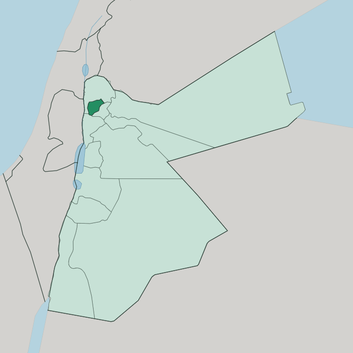
Towns & cities in Ajloun
Pick a town or city — each links to where to stay.
The town of Ajloun is the practical base, close to the castle and an easy run down to Jerash. Rooms cluster near the fortress. The most memorable beds are the cabins in the Ajloun Forest Reserve, run by the Royal Society for the Conservation of Nature as part of Wild Jordan, set among oak and carob and wild pistachio with walking trails to nearby villages.
Choose the reserve cabins if you want quiet forest and home-cooked local food; choose the town if you would rather be steps from Qal'at ar-Rabad. The pilgrim village of Anjara, just south, suits travellers drawn to its shrine.
About Ajloun
One building defines Ajloun.
What is Ajloun known for?
Ajloun Castle, known in Arabic as Qal'at ar-Rabad, was raised in 1184 by Izz al-Din Usama, a commander under Saladin, to watch over the northern Jordan Valley and the iron-mining passes below. The other draw is green rather than stone: the Ajloun Forest Reserve protects some of the last thick oak and pine woodland left in the country. Both sit in the town of Ajloun, the region's hub, a short drive from the Greco-Roman ruins at Jerash.
Castle, forest, and the pilgrim shrine at Anjara give the highlands their character.
Where is Ajloun?
Ajloun occupies the northern highlands of Jordan, about 76 kilometers north-west of Amman. It is a small region. Ridges of oak forest rise here to peaks near 1,268 meters, high enough to catch snow in a hard winter, and the land falls away sharply to the west toward the Jordan Valley and the river beyond.
The town of Ajloun sits near the centre of that upland, with the castle standing on a hilltop above it. Three valleys cut down through the forest from these hills. Wadi Kufranjah, Wadi Rajeb, and Wadi al-Yabis carry the winter water westward, and the second of them gives its name to Kufranjah, the region's other main town and the seat of its southern district.
Jerash lies just beyond the eastern edge, close enough for a half-day visit. Anjara sits four kilometers south of Ajloun town, tucked into the same wooded slopes. This is one of the greenest corners of a mostly dry country, and the forest is the reason people come.
What is Ajloun like?
Ajloun lives off its land and its faith. Olive groves cover roughly a third of the region, terraced across the hills, and the local olive oil is prized across Jordan. Arabic is the everyday language, and village life follows the farming year, with the autumn olive harvest the great communal event of the calendar.
Muslims and Christians have long shared these villages together. Anjara, four kilometers south of Ajloun town, holds one of the reasons: the Shrine of Our Lady of the Mountain, built over a cave where tradition says Jesus and the Virgin Mary rested on a journey between Galilee and Jerusalem. That shrine draws a yearly Catholic pilgrimage.
The forest shapes the culture as much as the churches and mosques do. Reserve rangers and village cooperatives sell honey, dried herbs, and biscuits made from local carob and wild strawberry, part of a small nature-tourism economy the Royal Society for the Conservation of Nature has built here. Food is simple and generous.
The upland cooking leans on olive oil, flatbread, and whatever the season gives.
What is the history of Ajloun?
Ajloun's story turns on its castle. In 1184 Izz al-Din Usama, a general serving Saladin, built Qal'at ar-Rabad on a commanding hilltop to guard the region's iron mines and the roads linking southern Jordan with Damascus, and to check the Crusader strongholds to the west. The Mamluks enlarged it in the following century, adding towers and a gate.
Settlement here is far older still. The mild climate, spring water, and fertile soil drew people to these hills long before the fortress rose, and the surrounding villages have been farmed continuously ever since.
What is the climate of Ajloun?
Ajloun has a Mediterranean climate, cooler and wetter than most of Jordan thanks to its height. Winters are cold and damp. Rain falls almost entirely between November and March, and the highest ridges near 1,268 meters can see snow two or three times a season.
Summers stay warm and dry, tempered by the forest and the altitude, which is exactly why the reserve fills with Ammanis fleeing the lowland heat below. Spring covers the oak slopes in wildflowers.
How do you get to Ajloun?
Nearly everyone comes from Amman. The drive north-west from the capital takes about 76 kilometers along good roads, roughly an hour and a half, and Ajloun is most often paired with Jerash on the same day trip out of the city. There is no railway and no airport in the region, so a hired car or a guided tour is the usual way in.
Local minibuses connect Ajloun town with Jerash and the surrounding villages for those travelling on their own.
Good for
Updated July 2026