Jordan
Muḩāfaz̧at aţ Ţafīlah, Jordan — Towns & Travel Guide


Muḩāfaz̧at aţ Ţafīlah is Jordan's least-peopled governorate, a high olive-country plateau falling west into the Dana gorge and Wadi Araba.
About Muḩāfaz̧at aţ Ţafīlah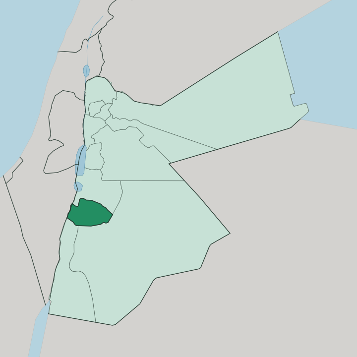
Towns & cities in Muḩāfaz̧at aţ Ţafīlah
Pick a town or city — each links to where to stay.
Beds cluster in two places. Ţafīlah town holds the ordinary hotels and the services, a highland base below Al-Tafilah Castle and within reach of the phosphate country at Al-Ḩasā. Yet most people come for Dana. The village of Dana keeps a cluster of restored stone guesthouses and eco-lodges on the rim of the reserve, and they fill through the walking season, so book the Wadi Dana trail beds well ahead.
Down in the valleys west of town the thermal resorts at Afra and Burbeita offer a quieter alternative fed by warm water. You choose Ţafīlah for the market and the springs; you choose Dana when the gorge and its trails are the whole reason for the trip.
About Muḩāfaz̧at aţ Ţafīlah
One reserve defines this governorate.
What is Muḩāfaz̧at aţ Ţafīlah known for?
The Dana Biosphere Reserve, Jordan's largest, tumbles from the Qadisiyah plateau near the town of Dana down through a widening gorge to the salt flats of Wadi Araba, crossing four biogeographic zones on the way. Ţafīlah town anchors the highlands, a compact market centre of olive and fig gardens fed by hundreds of springs. Hikers know it for the Dana trails and the thermal water at Afra and Burbeita. Phosphate mines out at Al-Ḩasā carry much of its working economy.
Where is Muḩāfaz̧at aţ Ţafīlah?
Muḩāfaz̧at aţ Ţafīlah lies in south-western Jordan, roughly 180 km down the highland road from Amman. It is the emptiest governorate in the country. Most of its towns sit high, above 1,000 metres on the eastern edge of the great rift, and the hill village of Rashadiya climbs to about 1,500 metres, the highest ground in the province.
From that plateau the land breaks westward. The Dana Biosphere Reserve carries the drop, plunging from the Qadisiyah escarpment through Wadi Dana to the salt-crusted floor of Wadi Araba, and that single descent passes through Mediterranean, Irano-Turanian, Saharo-Arabian, and Sudanian belts of plant and animal life. Karak Governorate borders it to the north, Ma'an Governorate to the east and south, and Aqaba Governorate to the south, while the deep trench of Wadi Araba forms the western edge. Springs are everywhere.
More than 360 natural springs rise in the Ţafīlah district alone, watering the olive and fig gardens for which the highlands are known, and the hot springs at Afra and Burbeita well up in the valleys below. Rift, plateau, and gorge order the whole of it.
What is Muḩāfaz̧at aţ Ţafīlah like?
Life here turns on the land and the seasons. The highlands are old farming country, and their olive terraces, fig trees, and grape-vines set the rhythm of the year as much as any calendar does, with the autumn olive pressing the great communal event of the district. Arabic is the language of the governorate, spoken in the strong tribal accent of the southern hills.
Hospitality runs deep in these towns. The old Ţafīlah market still trades produce off the terraces, and the spring-fed gardens draw families out to the water in the heat of summer. Bedouin custom threads through the reserve country too.
Herders still graze flocks along the edges of the Dana Biosphere Reserve, and the village guesthouses lean on that pastoral tradition for their food and their guides. History is worn lightly but present everywhere. The Edomite past, the Nabataean trade that ran up from Petra, and the memory of the 1918 fighting all sit close under the surface of daily life.
What binds it is a plain, water-conscious highland culture, unshowy and rooted in the terraces.
What is the history of Muḩāfaz̧at aţ Ţafīlah?
This was Edom. The governorate holds the heartland of the Edomite kingdom, whose stronghold stood at Busaira and whose highland people knew the town of Ţafīlah as Tophel. The Nabataeans of Petra later drew it into their caravan trade.
A Crusader lord named Martin held the district in 1177 before Ayyubid rule returned it to Muslim hands, and Ottoman authority followed. Its most famous day came in January 1918, when Arab Revolt forces guided by Lawrence of Arabia broke an Ottoman column here at the Battle of Tafilah. Farming, phosphate, and the reserve have shaped it since.
What is the climate of Muḩāfaz̧at aţ Ţafīlah?
The plateau runs semi-arid and cool. Rashadiya and the high towns take only about 240 mm of rain a year, most of it falling in the cold months, and winter can bring frost and even a dusting of snow to the highest ridges above 1,500 metres. Summers stay dry and bright, hot by day but tempered by the altitude after dark.
The picture flips as the land drops. Down in Wadi Araba and the lower reaches of the Dana gorge the air turns fiercely hot and truly desert. Spring greens the terraces briefly before the long dry stretch.
How do you get to Muḩāfaz̧at aţ Ţafīlah?
Everyone arrives by road. Ţafīlah has no airport and no railway, so travellers drive the roughly 180 km down from Amman, most by the Desert Highway and then west into the hills, some by the slower and far grander King's Highway that traces the rift past Karak Governorate. From the south the roads climb up out of Ma'an Governorate and the Petra country. For Dana, the turning leaves the King's Highway just north of Ţafīlah town.
Shared taxis and local buses stitch the towns together, but a hire car makes the reserve far easier to reach.
Updated July 2026