Kenya
Embu, Kenya — Towns & Travel Guide


Embu is a county on the south-eastern slopes of Mount Kenya, where tea highlands fall to the dry Mbeere lowlands and the Tana River.
About Embu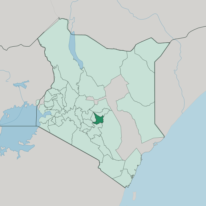


Towns & cities in Embu
Pick a town or city — each links to where to stay.
Embu town is the practical base, a stop on the Nairobi-Meru highway with the county's hotels and the quickest reach to Mount Kenya's forest gates. Start in Embu town. Uphill at Runyenjes the air cools among the tea and coffee smallholdings on Mount Kenya's flank.
Southward the land dries fast toward the Mwea plains, where lodges near Mwea National Reserve put visitors within a short drive of the Kamburu reservoir and its elephants. Deeper into the Mbeere country around Siakago, muguka farms replace hotels and most visitors day-trip in. Pick the town for comfort, the reserve edge for wildlife.
About Embu
Embu trades on the fertile ground of Mount Kenya.
What is Embu known for?
Its upper slopes grow some of Kenya's finest tea and coffee, sold through factories at Mukuriri and Kathangariri, and the county leads the African Great Lakes region in macadamia. Water is the other export. The Tana River drops through the Seven Forks dams here, turning the country's largest hydroelectric cascade, while Mwea National Reserve guards elephants and hippos on the shore of the Kamburu reservoir.
Down in the drier Mbeere lowlands, farmers plant muguka. Embu town anchors it all.
Where is Embu?
Embu sits on the south-eastern slopes of Mount Kenya, north-east of Nairobi in what was the old Eastern Province. The county tilts hard. It climbs from around 500 metres in the Tana River basin in the east to the frozen moorland below the peaks of Mount Kenya in the north-west, a rise of nearly four kilometres across one county.
That gradient sets everything else, the crops, the rainfall, the run of the rivers. Six perennial rivers drain the slope, and four of them, the Thũci, the Tana, the Kiĩ and the Rũvingasĩ, trace the county's boundaries. The high ground in the north and west is folded into ridges and steep valleys under forest.
Isolated hills such as Kiang'ombe, Kianjiru and Karue break the skyline where the tea country starts to flatten out. Southward it drops to the hot Mwea plains, rice country watered off the mountain. Along the eastern edge the Tana River has been dammed into the Seven Forks cascade, its reservoirs at Kamburu and Kiambere pooling against the boundary.
Beyond the tea belt lie the drier Mbeere lowlands, thorn scrub and red earth. The mountain feeds all of it.
What is Embu like?
Two related peoples share the county. The Embu farm the wet highland ridges, while the Mbeere hold the hot lowlands to the south, and though their tongues, Kiembu and Kimbeere, are close cousins, the way they live off the land splits along the same line the rain does. Highland Embu families work coffee, tea and macadamia; the county sends more macadamia to market than anywhere else in the African Great Lakes.
Down in Mbeere country, where rain is thin, households lean on livestock and on muguka, the mild stimulant leaf grown across the semi-arid lowlands. Both trace their roots to the Nyambene Hills north of Mount Kenya, from where their ancestors moved south and, by their own account, drove out an earlier people, the Gumba. Land and lineage still order much of rural life.
Farming is not just work here; it is identity, and the University of Embu grew straight out of an old agricultural college that trained the region's growers. Swahili and English carry business and school. Kiembu carries home.
Market days in Embu town pull both worlds down off the hills into one crowd.
What is the history of Embu?
The Embu reckon their arrival on the mountain to the fifteenth century, long before any map named the place. Colonial Kenya caught up with them in 1906, when a British military expedition broke local resistance and planted an administrative station on the site of the present town. That station became Embu, a district and provincial seat through the colonial decades and after independence.
The modern county is young. It was carved from the old Eastern Province in 2013, when Kenya redrew itself into counties and Embu took back its own name and boundaries.
What is the climate of Embu?
Height governs the weather more than season does. On Mount Kenya's slopes the days stay warm and the nights turn cool, and rainfall climbs with the land, sparse down in the Mbeere lowlands, but well over a metre a year up in the tea zone around Runyenjes. Two rainy seasons soak the county, the long rains around April and the short rains near November.
Between them it dries out. The clear, dusty stretch from June to October is the easiest time to travel the murram roads and see the mountain unclouded.
How do you get to Embu?
There is no airport at Embu. Nearly everyone flies into Nairobi, clears Jomo Kenyatta International Airport, then drives north-east for about two hours on the tarmac highway that climbs from the capital toward Mount Kenya. The road is the spine of the trip.
It runs on through Embu town to Meru and the eastern circuit, and matatus and buses work it all day. From Embu the forest gates of Mount Kenya and the game drives at Mwea National Reserve are each within an easy morning's drive.
Good for
Updated July 2026