Kenya
Garissa, Kenya — Towns & Travel Guide


Garissa County spans the dry plains of eastern Kenya, where the Tana River threads a green line through Somali herding country.
About Garissa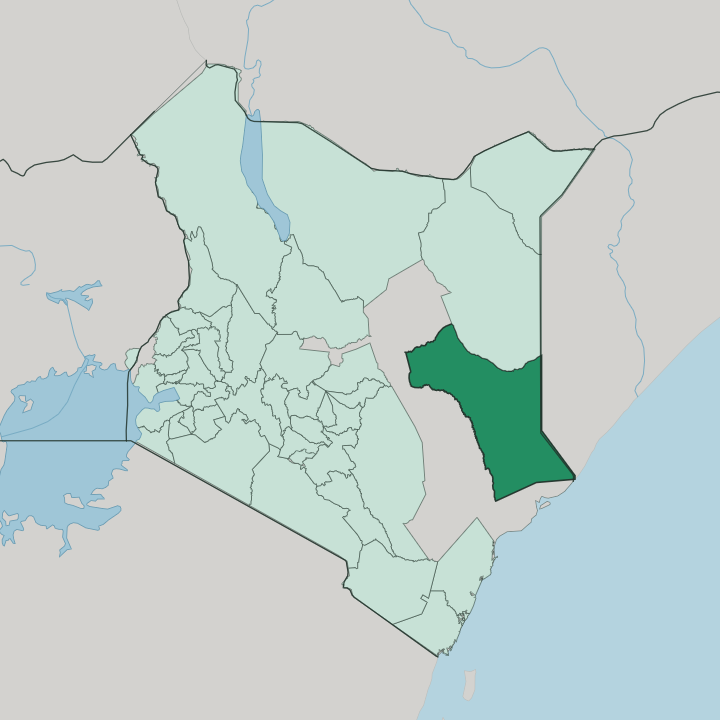


Towns & cities in Garissa
Pick a town or city — each links to where to stay.
Nearly every visitor bases in Garissa town, the county's only real urban centre, which sits on the east bank of the Tana River just beyond the bridge that carries the road in from Nairobi. Beds concentrate there. Simple guesthouses and a few air-conditioned resorts line the Lamu road, welcome shelter from the dry heat.
Bura and Masalani, downriver toward the delta, are the jumping-off points for the Ishaqbini Hirola Conservancy and the wildlife reserves closer to the coast. Dadaab is a place of aid work, not tourism. Choose Garissa town if you want the county's only dependable power, connections and beds.
About Garissa
What is Garissa known for?
Garissa town was the capital of Kenya's former North Eastern Province, and the county around it is a stretch of thorn-scrub plains between the Tana River and the Somali border. Two things define it. The Tana is Kenya's longest river and the county's only permanent water, so settled farming clusters along its banks while herders drive cattle, goats and camels across the drylands beyond.
Dadaab, near the border, grew into one of the world's largest refugee complexes after war drove Somalis across the frontier. Garissa town, on the river's east bank, is the trading and administrative heart of it all.
Where is Garissa?
Garissa County occupies the low, flat country of eastern Kenya, pressed against the Somali border in the east and reaching south toward the coastal counties of Lamu and Tana River. There are no mountains here. The land is a vast semi-arid plain of red soil and thorn bush, sloping so gently toward the Indian Ocean that a traveller barely notices the fall.
Acacia and commiphora scrub cover it, thickening to real woodland only along the watercourses. Wajir and Isiolo lie to the north, across the same dry rangeland that runs unbroken for tens of kilometres at a stretch. The Tana River is the exception that shapes everything.
Kenya's longest river rises far to the west on the slopes of Mount Kenya, then bends south to trace much of the county's western edge, a narrow ribbon of green cut through the drylands before it runs on toward the delta and the sea. Its banks hold the farmland, the mango and banana plots, and most of the permanent settlement. Garissa town grew up at the main crossing of the river.
Downstream sit Bura and the Ishaqbini Hirola Conservancy, a fenced refuge on the east bank for the hirola, an antelope found nowhere else on earth. Beyond the river the plains take over again, grazed by camels and cattle rather than farmed, and dotted with the seasonal water pans that pastoralist families move between.
What is Garissa like?
Life in Garissa is Somali and Muslim, part of a cultural world that pays no attention to the line drawn between Kenya and Somalia. The Somali language is heard everywhere, alongside Kiswahili and some English in the offices and schools. Islam orders the calendar.
Mosques mark the towns, Friday empties the markets, and the fasting month sets the rhythm of the year. Most families trace descent through Somali clans such as the Ogaden, Degodia and Ajuran, and lineage still frames marriage, politics and the sharing of grazing and water. Herding is the old backbone, and the camel is its measure of wealth.
Pastoralist families move stock between wet-season pans and the permanent water of the Tana, a way of life older than any border. Sweet spiced tea, grilled goat and rice, and camel milk are the everyday table. Poetry matters here.
Somali is a language famous for its oral verse, and reputation can still be made or lost in spoken words at a wedding or a gathering. The week bends toward Friday prayers and the livestock market, where camels, cattle and goats change hands and the county's real economy is done in the open air.
What is the history of Garissa?
Garissa began as a colonial staging post. The British planted a military and administrative station on the Tana here, in the arid tract they governed as the Northern Frontier District, deliberately kept apart from the rest of Kenya. Independence in 1963 brought the Shifta War, a secessionist revolt by ethnic Somalis who wanted the region joined to Somalia; years of counter-insurgency and forced villagization followed before it wound down in 1967.
The district became North Eastern Province, and decades of emergency rule. Garissa County itself was created in 2013, under the devolution of the 2010 constitution.
What is the climate of Garissa?
Garissa sits among the hottest lived-in country in Kenya, a hot arid land where the sun beats on the thorn plains through almost every month of the year. Rainfall barely reaches this thorn country. It arrives in two brief seasons, the long rains around April and the short rains around November, and fails often enough that drought is a familiar visitor.
Between them the plain cracks and browns. When the herds have nothing to graze, families drive them toward the Tana, the one river that holds water through the dry months.
How do you get to Garissa?
Most travellers reach Garissa overland from Nairobi. The tarmac A3 highway runs east from the capital through Thika and Mwingi, then crosses the Tana River on the long bridge into Garissa town, a drive of several hours. There is also a small airport.
Light aircraft link Garissa with Nairobi's Wilson field in about an hour, a quicker option when the rains turn the roads to mud. From the town, rough roads run east to the Somali border at Liboi, north-east to Dadaab, and south down the Tana toward the coast.
Updated July 2026