Kenya
Migori, Kenya — Towns & Travel Guide


Migori is a county in the far south-west of Kenya, where the Migori River runs gold-bearing gravel down to the shore of Lake Victoria.
About Migori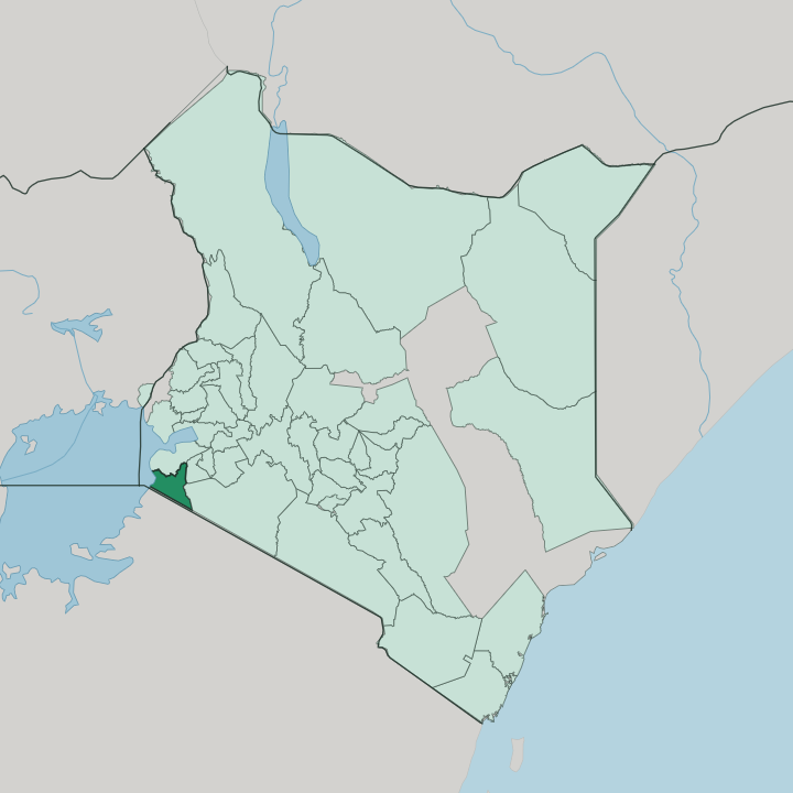


Towns & cities in Migori
Pick a town or city — each links to where to stay.
Migori town holds most of the county's beds and makes the obvious base, set where the Isebania road climbs east toward Kisii. Comfort is thin elsewhere. Awendo, grown around the Sony Sugar mill, offers a quieter alternative north up the highway.
Travellers bound for Tanzania often overnight at Isebania, on the Sirari frontier post itself. Down on the water, the fishing beaches at Muhuru Bay and Sori keep only plain guesthouses for anglers and traders. Choose the town for a proper room; choose the lakeshore to wake with the boats.
About Migori
What is Migori known for?
Two things carry Migori's name beyond the county. One is Thimlich Ohinga, a dry-stone walled settlement north-west of Migori town that was raised without mortar around the 16th century and inscribed by UNESCO in 2018. The other is gold.
The Migori Gold Belt threads the river valley in the county's east, worked by artisanal miners around the old Macalder Mines since colonial prospectors first cut shafts there. Sugarcane is the steadier earner, milled at the Sony Sugar plant near Awendo, and canoes still bring tilapia in from Lake Victoria at dawn.
Where is Migori?
Migori sits in the far south-west of Kenya, in what was the Nyanza Province before the counties were drawn. Tanzania runs along its southern and eastern edge. To the north lies Homa Bay County, to the north-east the highlands of Kisii County, and to the east the Maasai rangelands of Narok County.
The western boundary is water: the county's shore runs along Lake Victoria out to the fishing rock of Migingo Island, a speck still contested between Kenya and Uganda across the lake. Two rivers give the county its shape. The Migori River rises far to the east in Maasai country and cuts west through the goldfields around Macalder.
There it takes in the Gucha, which drains the Kisii highlands, and the combined Gucha-Migori empties into Lake Victoria. The whole drainage tilts toward the lake. Between the rivers the land is a run of low, undulating hills, dropping to its lowest along the lakeshore in Nyatike.
It is warm, green, and worked hard. Sugarcane and maize cover the better ground, while the drier slopes rising toward the Tanzanian border carry cattle and tobacco.
What is Migori like?
Most of Migori is Luo country, and Dholuo is the everyday language of its markets and lakeshore. Life along Lake Victoria turns on fishing. Boats go out before light from Muhuru Bay and Sori, and the day's tilapia and omena fill the drying racks by mid-morning.
The Luo keep a strong oral tradition of proverbs, riddles and sung history, and the guitar-driven benga that grew up in this part of Nyanza carries it into song. Each Luo homestead is a dala, a family compound ringed by its own hedge rather than a clustered village. The south is different.
There the Kuria hold the land toward the Tanzanian border around Kehancha and Isebania, a Bantu people whose speech, Ekigurya, has nothing in common with Dholuo. Kuria society is built on age-sets that bind men into warriors and elders, and the farming year ends with Ekerubo, a post-harvest season of bullfights where prize bulls are matched before whole villages. Cattle still measure wealth and settle marriages here.
Market days pull the two worlds together, when Luo fish traders and Kuria cattle keepers crowd the same roadside stalls at Migori and Awendo.
What is the history of Migori?
People here built in stone. The enclosures at Thimlich Ohinga went up around the 16th century, raised without mortar by the early herding communities that first walled the Lake Victoria basin against raiders and lions. Luo clans reached the lakeshore over later centuries, while the Kuria took the hills toward present-day Tanzania.
Then came gold. Prospectors opened the Macalder mines in the colonial decades, and the South Nyanza Sugar factory followed at Awendo in 1976. Migori County itself is young, carved out under Kenya's 2010 constitution when devolution replaced the old districts in 2013.
What is the climate of Migori?
Migori lies just south of the equator, and its weather runs on rain, not seasons of heat and cold. Here the calendar turns on two rainy spells rather than warm and cold seasons. Long rains soak the county from March into June, short rains return around October and last to December, and April is reliably the wettest month of all.
July is the driest stretch. Days stay warm and often overcast through the year, tempered by the county's hills and the cool breath off Lake Victoria. Cropping follows the rain, not the calendar.
How do you get to Migori?
Most people reach Migori by road. The A1 highway drops down from Kisii and the Kisumu direction to run through Migori town, and matatus grind in from Kisumu in about three hours by way of Homa Bay. There is a small airstrip, Migori Airport, but scheduled flights land at Kisumu, a couple of hours north on the lake.
South of town the tarmac carries straight on to the Isebania crossing, where travellers step over the Sirari post into Tanzania and on toward Tarime and the Serengeti plains.
Good for
Updated July 2026