Kenya
Nandi, Kenya — Towns & Travel Guide


Nandi is a highland tea county in western Kenya, on the edge of the Great Rift Valley and famed for its Kalenjin distance runners.
Find your area →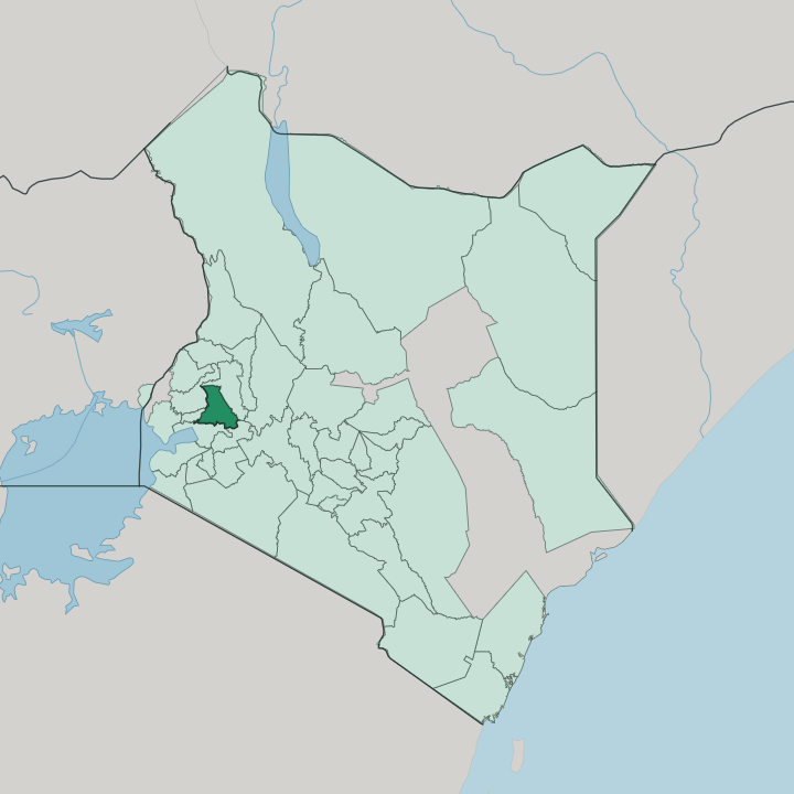


Towns & cities in Nandi
Pick a town or city — each links to where to stay.
Kapsabet is the obvious base. It is the county town, where the running camps and the daily market sit side by side. Nandi Hills, out on the tea escarpment, keeps a handful of guesthouses near the Koitalel arap Samoei mausoleum, but past those two towns most villages have no formal hotel.
Many travellers sleep in Kisumu, the Lake Victoria city just south below the escarpment, or in Eldoret over in the Uasin Gishu highlands, both of which have airports and a full spread of hotels. Choose Kapsabet for the runners; drop to Kisumu when you want a full-service room.
About Nandi
What is Nandi known for?
Two things carry Nandi's name. Its tea estates blanket the hills around Nandi Hills town and Kapsabet, fed by deep red volcanic soil and steady highland rain, and the county sends more champion distance runners onto the track than almost any patch of ground on earth. Kip Keino grew up on these ridges, and Eliud Kipchoge was born here.
The Kalenjin call this the source of champions. Kapsabet is the working heart of it all, market town and running capital at once.
Where is Nandi?
Nandi sits in the North Rift of western Kenya, a green highland block west of the escarpment that gives it its name. The county fills a jug-shaped plateau of rolling hills and red volcanic soil, tilted between the cool uplands in the north and the warm plains that drop away in the south. Its southern edge runs down to the Equator.
From there the Nandi Escarpment plunges toward the Kano plains and the Lake Victoria basin around Kisumu, a fall of hundreds of metres in a few ridgelines. Kapsabet stands near the middle, the plateau's market and administrative centre. Geographers split the county into five distinct zones.
Those zones read like a cross-section of the highlands. The Kapsabet Plateau carries most of the farms and towns; the Tinderet volcanic mass rises forested in the south-east; the King'wal Swamp holds the headwaters and its rare sitatunga antelope; and the rolling northern hills roll on toward Mosop. Rivers thread all of it.
The Kimondi meets the Sirua to form the Yala, which rises on this escarpment and runs west to Lake Victoria. Uasin Gishu lies to the east, Kericho to the south-east, Kisumu to the south, and Kakamega to the west. Every border is another Kenyan county.
The land never really flattens.
What is Nandi like?
The people here are Nandi, a section of the Kalenjin who have farmed and herded these highlands for generations. Their world was ordered by age-sets and clans, boys passing through initiation into warriorhood and then into the councils of elders who settled disputes and led in war. Cattle mattered.
On the tea estates the working day runs from Kapsabet out to the factories above Nandi Hills, and dairy and maize fill the smallholdings between. Kalenjin is the everyday tongue, with Swahili and English carrying the wider business of Kenya. But Nandi is known to the world for something narrower: running.
These ridges, high and thin-aired, have produced a line of Olympic distance champions out of all proportion to their size. Kipchoge Keino broke through on the track in the era of Mexico City and Munich. Eliud Kipchoge, born in a village near Kapsabet, later rewrote the marathon.
Local people call the county the source of champions, and the red-dirt roads fill with runners before dawn. Children run to school along them. The altitude does part of the work; the rest is a culture that treats the sport as a way out and up.
What is the history of Nandi?
Nandi fought the British longer than almost anywhere in the country. When the Uganda Railway pushed toward the highlands, the Nandi rose against the iron line, tearing up telegraph wire and raiding the work camps under their Orkoiyot, the spiritual and war leader Koitalel arap Samoei. The resistance held for roughly a decade.
It ended by treachery. In 1905 a British officer, Richard Meinertzhagen, marched up from the fort at Kaptumo and shot Koitalel dead at a sham peace meeting at Ketbarak, beside Nandi Hills. His mausoleum stands at Nandi Hills.
What is the climate of Nandi?
Altitude runs the weather here. Nandi sits high enough that the equatorial sun stays gentle, and the plateau keeps a cool, green climate through most of the year. Rain comes in two seasons, drawn around the equinoxes, with the long rains soaking the hills from spring and a shorter turn later on.
Mist settles in the tea at dawn. It is this pairing of steady rain and deep volcanic soil that makes the Nandi Hills such tea country. Frost is unknown; the cold is a highland damp, not a winter.
How do you get to Nandi?
No airport lies within the county. The nearest runways are at Kisumu, on the shore of Lake Victoria to the south, and at Eldoret in the Uasin Gishu highlands to the east, each within a couple of hours of Kapsabet by road. Kisumu's approach climbs the Nandi Escarpment in a run of switchbacks.
Coming from Eldoret, the drive rolls in gently across the open highlands. The Uganda Railway that the Nandi once fought still skirts the county, though the tarmac roads carry the traffic. From either airport, matatus and buses grind up to Kapsabet and Nandi Hills.
Common questions
What is the best area to stay in Nandi?
Kisumu: lakeside hotels and the nearest flights.
Good for
Updated July 2026