Kenya
Nyandarua, Kenya — Towns & Travel Guide


Nyandarua is a highland county in central Kenya, a farming plateau caught between the Aberdare Range and the Great Rift Valley.
About Nyandarua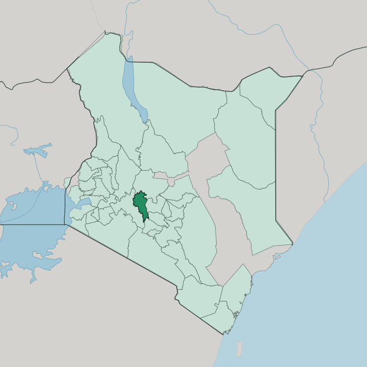


Towns & cities in Nyandarua
Pick a town or city — each links to where to stay.
Nyandarua is no resort county. Its beds are mostly plain guesthouses and farm-stays gathered in the market towns, with a scattering of cottages and tented camps out by the water. Ol Kalou, the county town, is the practical base for services and transport.
Njabini, in the south, is the usual staging point for walkers heading onto the Aberdare Range from the Nairobi side. Small cottages and camps line the shore of Lake Ol Bolossat. Choose Ol Kalou for errands; choose the lakeshore or Njabini when the highland landscape itself is what you have come to see.
About Nyandarua
What is Nyandarua known for?
Nyandarua is farming country, one of the plateaus that feed Kenya's cities with potatoes, cabbages, carrots, and milk. The land sits high. Its eastern wall is the Aberdare Range, whose forests and high moorland fall inside Aberdare National Park, where elephant, buffalo, and mountain waterfalls draw walkers up from the towns below.
Mount Satima, the highest peak of the range, rises at its northern end above the Kinangop Plateau. Ol Kalou, the county town, anchors the smallholder dairy trade that defines the region far more than tourism does.
Where is Nyandarua?
Nyandarua fills a stretch of the central Kenyan highlands, a tilted farming plateau west of Mount Kenya and north of Nairobi. Its whole eastern edge is a wall of mountains. The Aberdare Range runs the length of that border, a forested massif whose upper slopes climb into moorland and rise, at the northern end, to the bare summit of Mount Satima.
The county is named for this range; Nyandarua is the Kikuyu word for a drying hide, after the folded silhouette of the peaks. West of the mountains the land drops toward the floor of the Great Rift Valley, and Nakuru lies out that way. Most of the county sits high, a cool tableland of ridges and shallow valleys.
Rivers rise in the Aberdare forests and run off in every direction. On the plain near the Wanjohi Valley lies Lake Ol Bolossat, the only lake in this part of the country and the source of the Ewaso Ng'iro that flows north toward the drylands. Mount Kipipiri stands apart from the main range, a separate volcanic cone above the Kinangop Plateau.
Farms cover almost all of it. Ol Kalou, the county town, sits on the western side of the Aberdares within reach of Nakuru down in the Rift, while Nyahururu, the former capital, lies just across the northern boundary in the neighbouring county of Laikipia. Little high forest survives beyond the park.
What is Nyandarua like?
Nyandarua is Kikuyu country, and its rhythm is agricultural. Almost everyone farms. The plateau is a patchwork of smallholdings growing potatoes, cabbages, carrots, and pyrethrum, worked between herds of dairy cattle that supply the milk coolers and creameries down the line.
Market days pull the district together, when produce from the ridges comes down to Ol Kalou and the smaller centres. The everyday languages are Gikuyu at home and Swahili in the market and the school. This high ground carries a heavy colonial memory.
In the Wanjohi Valley, above the plateau, British settlers of the interwar decades ran the estates that gossip named the Happy Valley set, a byword for scandal and idleness among the white planters of the highlands. The same forests hold a very different memory. During the fight against colonial rule the Aberdare Range sheltered the fighters of the Mau Mau rebellion, and Dedan Kimathi commanded his forest army from these slopes.
That double past still shadows the county. Life otherwise is quiet and rural, tied to weather, cattle, and the long climb of the land toward the mountains.
What is the history of Nyandarua?
Nyandarua the county is young, drawn up as a devolved unit of Kenya in 2013. The land is not. In the colonial decades these highlands were fenced off as part of the White Highlands and farmed by European settlers, while the Kikuyu who had lived and grazed here were pushed to the margins.
The Aberdare Range then became a refuge of the Mau Mau rebellion, and after independence the old settler estates were broken up and resettled by Kikuyu smallholders. Those settlement schemes drew the map of farms that covers the plateau.
What is the climate of Nyandarua?
Height sets the weather here. Although it sits nearly on the equator, Nyandarua is cool the year round, because the whole county lies far above the warm plains and the air thins with the climb. Two rainy seasons cross it, the long rains around April and May and the short rains toward the end of the year, both fed by cloud banking against the Aberdare Range.
The high moorland of the Kinangop can turn cold enough for night frost. Mornings are often misty; afternoons clear over the ridges.
How do you get to Nyandarua?
Everything arrives by road. The plateau has no airport of its own, so travellers drive up from Nairobi, climbing the Rift escarpment past Naivasha and crossing into the county near Njabini in the south. From the other side the way in runs from Nakuru, the nearest large city, up off the floor of the Rift toward Ol Kalou.
The Aberdare Range walls out any straight road from the east, so traffic from the Mount Kenya side has to loop around the mountains. The nearest major airport is at Nairobi.
Good for
Updated July 2026