Kenya
Nyeri, Kenya — Towns & Travel Guide


Nyeri County spreads across Kenya's Central Highlands, between the Aberdare Range and the western slopes of Mount Kenya.
About Nyeri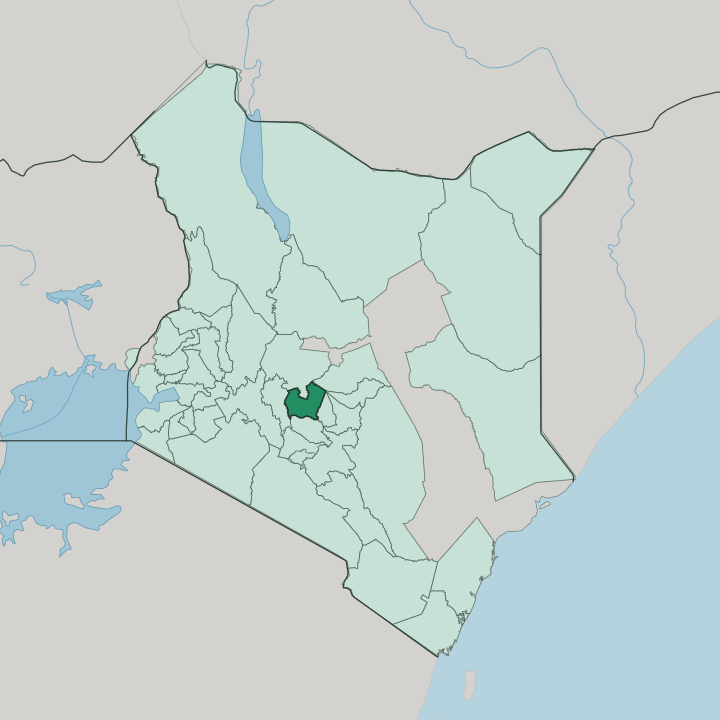


Towns & cities in Nyeri
Pick a town or city — each links to where to stay.
Nyeri town makes the practical base, with its Outspan cottages and easy roads out to the parks. Safari-goers go higher. The Aberdare National Park holds Treetops and the forest waterhole lodges on the range's eastern slope, while Mweiga sits just outside the park's main gate.
Naro Moru, on the Mount Kenya side, is the classic staging post for climbers heading up the mountain. Pick the town for convenience; pick a mountain lodge when the wildlife is the point.
About Nyeri
Two great massifs define Nyeri.
What is Nyeri known for?
The county sits on a saddle of farmland between the Aberdare Range to the west and Mount Kenya to the east, the two highest points of the Central Highlands. Coffee and tea grow on the red volcanic soil, and the county is Kikuyu country at its core. Nyeri town is the commercial hub, while Karatina, to the south, runs a sprawling open-air market that draws farmers from across the highlands.
Most travellers come for the mountains, the Aberdare National Park forests, and the safari lodges tucked among them.
Where is Nyeri?
Nyeri County occupies a slice of Kenya's Central Highlands, north of Nairobi and just south of the equator. It is hemmed in by mountains on both sides. The Aberdare Range rises along the western edge, a forested wall of upland that forms part of the eastern rim of the Great Rift Valley.
To the east stand the western slopes of Mount Kenya, the second-highest mountain in Africa. Between the two lies a saddle of high, tilted farmland at well over a mile of elevation, the ridged country that gives the county its cool air and deep red soil. Water shapes the land here.
Streams pour off both ranges and gather into rivers that thread down the central valley. The Gura drains the Aberdare slopes and joins the Sagana, and these highland streams feed the headwaters of the Tana, the longest river in Kenya, which begins its long arc toward the Indian Ocean in these hills. Nyeri town stands on the higher western ground, closer to the Aberdares, while Karatina sits lower and to the south.
Naro Moru, Mweiga and Othaya ring the county around them. Ridge, forest and river repeat across the whole county, and little of it lies flat.
What is Nyeri like?
Nyeri is Kikuyu country. The county lies at the heart of the Kikuyu homeland, and the language and customs of that community shape daily life across its ridges. Farming is the backbone of that life.
Smallholders work terraced plots of coffee, tea and dairy cattle on the volcanic soil, and the weekly market at Karatina pulls growers down from the surrounding hills to trade. Coffee grown on these slopes carries the county's name well beyond Kenya. Karatina holds one of central Kenya's largest open-air markets.
The place has produced people who reach far past its borders. Wangari Maathai, the first African woman to win the Nobel Peace Prize, was born at Ihithe near Nyeri and grew up among these hills before founding a movement to plant millions of trees. Mwai Kibaki, the country's third president, came from Othaya in the south of the county.
Nyeri also drew Robert Baden-Powell, founder of the Scout movement, who spent his last years in a cottage above Nyeri town and asked to be buried within sight of Mount Kenya. Scouts still travel here to stand at his grave.
What is the history of Nyeri?
The county was drawn on the map in 2013. Its place in Kenya's story runs far deeper than that. Nyeri was a heartland of the Mau Mau uprising, and through the 1950s fighters used the Aberdare Range forests as cover against colonial troops.
Dedan Kimathi, the movement's best-known leader, was captured near Nyeri in 1956. Grand colonial hotels rose here too. It was at Treetops, in the forest nearby, that Princess Elizabeth became queen on her father's death in 1952, and Robert Baden-Powell, founder of the Scout movement, chose the town for his final years and his grave.
What is the climate of Nyeri?
Height sets the weather here. Though Nyeri lies almost on the equator, its perch above a mile high keeps the air cool and springlike through the year, with genuinely cold nights on the higher ground toward the Aberdares. Two rainy seasons soak the county: the long rains around April and shorter rains late in the year, wrung out of clouds banking against Mount Kenya and the Aberdare Range.
Mornings often open clear, with both mountains showing, before cloud gathers by the afternoon.
How do you get to Nyeri?
Almost everyone arrives overland from Nairobi. The capital's airports are the country's main gateways, and Nyeri sits about a hundred and fifty kilometres north of the city, a few hours' drive up the tarmac through the coffee ridges. The road climbs steadily out of Nairobi into the highlands, passing Karatina before it reaches Nyeri town.
From there, side roads branch west to Mweiga and east toward Mount Kenya at Naro Moru. There is no passenger airport in the county itself.
Good for
Updated July 2026