Kenya
Tharaka - Nithi, Kenya — Towns & Travel Guide


Tharaka-Nithi rises from semi-arid plains near the Tana River up the eastern face of Mount Kenya, a farming county centred on Chuka.
About Tharaka - Nithi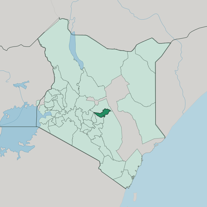


Towns & cities in Tharaka - Nithi
Pick a town or city — each links to where to stay.
Most beds cluster in Chuka, the commercial hub strung along the Nairobi-Meru highway a short walk from Chuka University and its stream of student traffic. Chogoria is the climbers' base. Trekkers overnight there before the Chogoria route carries them up past the Gorges Valley.
Kathwana holds the county offices but little for a traveller. Choose Chuka for restaurants and transport; choose Chogoria if you want Mount Kenya at your door.
About Tharaka - Nithi
What is Tharaka - Nithi known for?
The eastern face of Mount Kenya is the county's headline. Its share of the mountain forest reserve feeds the Chogoria route, the trail that climbers take up the Gorges Valley past the tiered Nithi Falls toward the summit. Chuka anchors the tea and coffee belt on the wetter slopes.
Down east, the land dries into the Tharaka plains that fall away to the Tana River. Two worlds, one county.
Where is Tharaka - Nithi?
Tharaka-Nithi sits in central Kenya on the eastern side of Mount Kenya, just south of the equator. The county climbs in bands. Its western edge reaches the mountain's ice near the summit, then drops through dense forest, tea gardens and coffee smallholdings before flattening into the hot Tharaka plains in the east.
Those lowlands run down toward the Tana River, the longest river in Kenya, which traces the county's dry eastern boundary. Between glacier and thornbush lies barely a day's drive. Three landscapes give the county its shape, each carrying a name from the districts that merged to form it.
Chuka and the Maara highlands catch the mountain's rain and grow tea and coffee. Some 360 square kilometres of the Mount Kenya forest reserve fall inside the western boundary, a catchment that feeds the upper Tana River. Kathwana, picked for its central position, holds the county government.
Tharaka, the semi-arid east, bakes under thorn scrub where farmers plant sorghum, millet and green grams. The Chogoria route threads up the western wall, following a ridge above the Nithi River into the Gorges Valley. Rain decides the rest.
What is Tharaka - Nithi like?
Four peoples share the county, all branches of the Ameru community: the Chuka, the Muthambi, the Mwimbi and the Tharaka. They speak dialects of Kimeru, the Bantu tongue of the wider Meru highlands, with the eastern lowlanders keeping the distinct Kitharaka of the plains. Ameru oral history traces the community back to Mbwaa on the coast, remembered as the island of Manda, from where the clans moved inland generations ago.
Elders still matter. A council of elders, the kiama, once settled disputes and set the calendar of age-set initiations that ranked every man by the year of his circumcision. Christianity arrived with the Scottish mission at Chogoria, where Clive Irvine opened a hospital in 1922 that still serves the eastern slopes.
Most people here are Catholic, Presbyterian or Methodist. Church life sits easily beside older custom. Daily rhythm follows the shamba, the family farm: coffee and tea on the cool heights, sorghum and millet where the rain thins toward Tharaka.
Market days pull the ridges together at Chuka and Kathwana. Land, rain and lineage still shape a life here more than any city does.
What is the history of Tharaka - Nithi?
The county's two halves were once two districts, and its hyphenated name records the join. Until 1992 this was all part of the old Meru District. That year Meru split into four, and two of the pieces, Tharaka in the dry east and Nithi, the former Meru South named for the Nithi River, were later fused into one Tharaka-Nithi District.
The 2010 Constitution turned that district into a county, and devolved government took office in 2013. Plain and highland stayed uneasy neighbours.
What is the climate of Tharaka - Nithi?
Altitude writes the weather here. On Mount Kenya's eastern slopes around Chuka and Maara, the air stays cool and the rain is reliable, enough for tea and coffee through two wet seasons, the long rains from March, the short rains late in the year. Drop east into Tharaka and the pattern breaks.
The plains turn hot and thirsty, scraping by on between 500 and 800 millimetres a year, so herders and sorghum farmers watch the sky. Same county, two skies.
How do you get to Tharaka - Nithi?
No airport serves the county. Nearly everyone arrives by road, driving up from Nairobi on the tarmac highway that threads through Embu and climbs the eastern flank of the highlands toward Meru. Buses and matatus run this corridor from dawn, setting down at Chuka and Chogoria after the steep, accident-prone drop to the Nithi River.
From Chogoria a rough track climbs to the Mount Kenya trailhead. Half a day from the capital, and the mountain fills the windscreen.
Good for
Updated July 2026