Thailand
Changwat Phatthalung, Thailand — Towns & Travel Guide


Changwat Phatthalung is a landlocked province of southern Thailand, set between the Banthat Range and the wetlands of Songkhla Lake.
About Changwat Phatthalung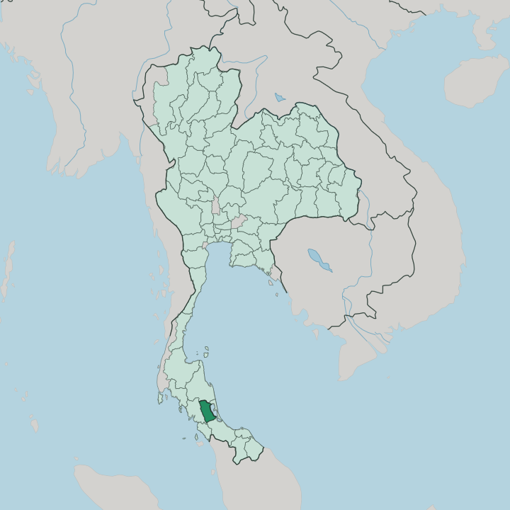


Towns & cities in Changwat Phatthalung
Pick a town or city — each links to where to stay.
Most visitors base in Phatthalung town, the compact capital below Khao Ok Thalu, where the Southern Line station, the market, and songthaews to the lake sit within a few streets. For the wetlands, sleep on the water. Stilt homestays gather where the Pak Pra canal opens into Thale Noi, and their boats leave at first light across fields of water lilies toward the bird-loud reeds of Songkhla Lake.
For waterfalls and cave shrines, head west into the foothills of the Banthat Range around Khao Pu-Khao Ya. Choose the town for arrivals; pick the lakeshore if you want the birds at dawn.
About Changwat Phatthalung
What is Changwat Phatthalung known for?
Two things carry the province's name. Nang talung, the leather shadow-puppet theatre of the south, takes its very name from Phatthalung, and the graceful Nora dance-drama traces its legend to the old court here. The land is as distinctive as the art: rice paddies run flat from the Banthat Range in the west to the reeds of Thale Noi, the freshwater wetland at the head of Songkhla Lake.
Over the capital rises Khao Ok Thalu, a limestone peak pierced by a natural gap that puts the mountain on the provincial seal. Puppets, paddies, and a holed mountain.
Where is Changwat Phatthalung?
Changwat Phatthalung lies on the eastern flank of the Malay Peninsula, in southern Thailand, and it is one of only two provinces of the south with no coast on the open sea. The line that would be its shore is a lake instead. Along the whole eastern edge stretches Songkhla Lake, the largest natural lake in Thailand and in truth a shallow lagoon that drains south to the Gulf of Thailand.
At its northern head, inside the province, the water shallows into Thale Noi, a reed-and-lotus wetland alive with waterbirds. West of the paddies the ground climbs fast. The Banthat Range, the local wall of the Nakhon Si Thammarat mountains, runs north to south and marks the border with Trang.
Limestone rises straight from the plain in places, and the most famous outcrop, Khao Ok Thalu, stands over the capital with a natural window bored clean through its crest. Between lake and mountain lies a broad, wet plain. Rice grows across it.
Short rivers spill out of the Banthat Range and wander east through the fields before losing themselves in the reeds and channels of the lake. The province shares land borders with Nakhon Si Thammarat to the north and Songkhla, which wraps around the far shore of the lake, to the east and south. Much of the western upland is protected as forest and wildlife sanctuary, dense country that shelters the sources of those rivers.
It is a small province, easily crossed in a day, yet it holds mountain, wetland, and lake shore all at once.
What is Changwat Phatthalung like?
Culture here is bound up with performance. Nang talung, the shadow theatre of southern Thailand, carries the province in its very name, talung being a worn-down form of Phatthalung. A single puppeteer sits behind a lit screen, voicing every character, cracking jokes about the day's news while carved leather figures dance against the light.
The other great southern art, Nora, is older still. This masked, acrobatic dance-drama traces its founding legend to the old ruling house of Phatthalung, and it was written into the UNESCO heritage lists as a living tradition of the south. Both arts are music, satire, and ritual at once.
Away from the stage, life follows the rice year and the water. Most people here are Buddhist, with a long-settled Muslim minority whose mosques stand among the village wats, an inheritance of the old Malay world of the peninsula. The lake feeds the kitchen.
Freshwater fish from Songkhla Lake, sun-dried and grilled, fierce southern curries, and the herb-and-rice salad khao yam all belong to the local table. Villages of stilt houses stand out in the shallows of Thale Noi, reached by long-tail boat, where families still fish and cut reeds for mats. It is a quiet, rural province.
Its fame rests on art and birds, not beaches.
What is the history of Changwat Phatthalung?
Phatthalung is an old town by southern standards. Under the Ayutthaya Kingdom it ranked among the tier of walled provincial cities that guarded the peninsula's trade and rice, and its governors gave rise to the founding legend of Nora. Its position was never fixed.
War, flood, and shifting trade moved the settlement more than once around the lake shore. The present capital was laid out on its current site in 1924, in the reign of King Rama VI. Older Phatthalung survives in temple ruins and hillside caves nearby.
What is the climate of Changwat Phatthalung?
Phatthalung runs hot and humid the year round, in the tropical monsoon belt of the peninsula. There is no cool season here. The heaviest rain comes late in the year, when the northeast monsoon drives moisture off the Gulf of Thailand and dumps it against the Banthat Range, and November is reliably the wettest month of all.
Flood water spreads over the paddies and swells Thale Noi in that stretch. The drier months early in the year bring steadier sun, though a shower is never far off. Green is the province's colour.
How do you get to Changwat Phatthalung?
The train is the classic way in. Phatthalung sits on the Southern Line, the long single-track railway that runs down the peninsula from Bangkok toward the Malaysian border, and sleeper trains set down passengers right in the middle of the capital. No airport lies within the province.
Most fliers land instead at Hat Yai in Songkhla or at Trang, each within a couple of hours by road. From the town, songthaews and hired boats carry visitors out to Thale Noi and the lake villages. Roads run north to Nakhon Si Thammarat as well.
Good for
Updated July 2026