Thailand
Changwat Phetchabun, Thailand — Towns & Travel Guide


Phetchabun is a mountain-walled province of lower northern Thailand, where the Pa Sak River runs between forested ranges and the cool Khao Kho highlands.
About Changwat Phetchabun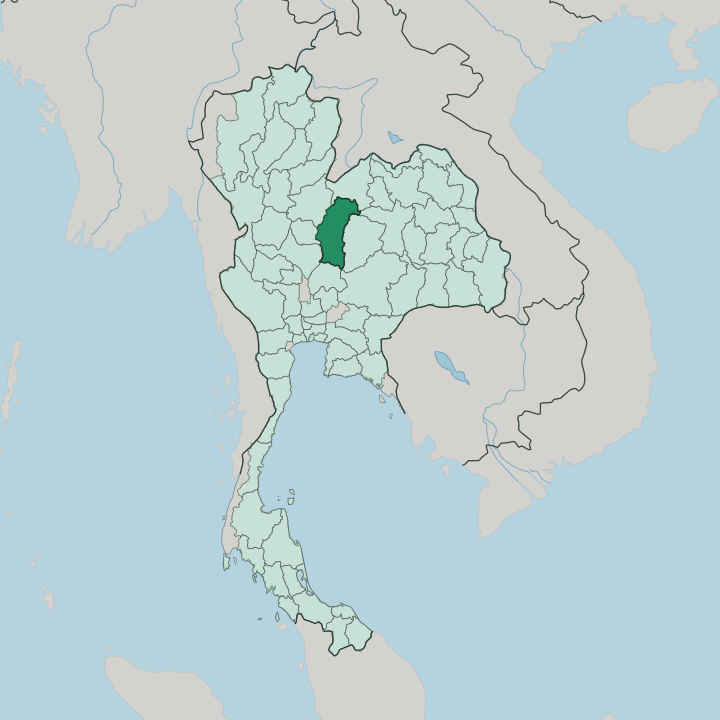


Towns & cities in Changwat Phetchabun
Pick a town or city — each links to where to stay.
Base yourself by altitude. Khao Kho is the classic mountain retreat, a cluster of ridge-top resorts and coffee farms where the air stays cool the year round. Phetchabun town, the capital down in the Pa Sak valley, suits travellers who want markets, temples and an easy run to the Si Thep ruins.
For sunrise above the clouds you camp higher still, on Phu Thap Boek. Lom Sak sits north of the capital, a handy stop on the way to Nam Nao National Park and the Loei road.
About Changwat Phetchabun
Two things put Phetchabun on the map.
What is Changwat Phetchabun known for?
The cool mountain resorts of Khao Kho draw weekenders up from the plains for misty ridgelines and flower farms, while the ancient town of Si Thep, a UNESCO World Heritage site since 2023, anchors its deeper past. The province grows Thailand's most prized sweet tamarind, celebrated each dry season with a fair in the capital. Campers climb Phu Thap Boek for sunrise above a sea of cloud.
Forest parks such as Nam Nao National Park spread across the ranges.
Where is Changwat Phetchabun?
Phetchabun lies in lower northern Thailand, on the seam between the country's northern hills and its central plains. The Pa Sak River is the organising line. It rises in the northern mountains and runs the length of the province from north to south, carving out the wide, fertile valley where most people farm and live.
Walls of forest rise on either side. The Phetchabun Mountains flank that valley east and west, and it is these ranges, not any coastline, that define the province. Landlocked provinces ring it on every side.
Loei lies to the north, Khon Kaen and Chaiyaphum to the east across the hills, Lopburi to the south, and Phitsanulok, Phichit and Nakhon Sawan to the west. Near the Loei border stands Phu Thap Boek, the highest peak in the province and the roof of the whole region. Forest still covers roughly a third of the land.
In the far north the ground climbs onto the cool Nam Nao plateau, where pine and grassland replace the lowland paddy. Down in the trough the Pa Sak River waters tamarind orchards, tobacco and paddy, while cabbages and coffee grow on the terraced slopes above. The shape of it all is long and narrow, drawn out along the river from the Loei hills down toward the central plain. Bangkok lies well to the south-west, a long haul up Highway 21 through the valley rather than a short hop.
What is Changwat Phetchabun like?
Phetchabun's signature event happens in the river. Each year at the close of Buddhist Lent, townsfolk carry the revered Phra Phuttha Maha Thammaracha image down to the Pa Sak River and plunge it beneath the water, a rite called Um Phra Dam Nam that belongs to nowhere else in Thailand. Local belief holds the statue washed itself in the same river centuries ago.
The custom runs some four hundred years deep. Food carries its own pride here. The province grows the country's sweetest tamarind, the makham wan, and honours the harvest each dry season with a fair where growers compete pod for pod.
Up in the mountains the culture shifts. Hmong communities farm the high slopes around Khao Kho and Phu Thap Boek, and the village of Khek Noi holds the largest Hmong community in the country. Their cabbage terraces and strawberry plots have become part of the cool-season draw.
Down on the valley floor life follows the older Thai-Buddhist rhythm of temple, market and river. When the cold months arrive, city people drive up from the plains to stand in genuine chill, wrapped against a cold that most of Thailand never feels. That contrast is the whole appeal.
What is the history of Changwat Phetchabun?
The oldest chapter lies at Si Thep. This walled twin-town rose well over a thousand years ago, shaped by the Dvaravati culture before the Khmer arrived. It grew into one of the great early cities of the region, and its ruins were inscribed as a UNESCO World Heritage site in 2023.
Later the valley passed under Sukhothai and then Ayutthaya. Its most recent past is harsher. Through the mountains around Khao Kho, the army and communist insurgents fought a long jungle war that ended only in the early 1980s.
What is the climate of Changwat Phetchabun?
Two climates share one province. The Pa Sak valley floor runs hot and tropical, soaked by the southwest monsoon from around May to October and merely warm through the dry months. The mountains are a different world.
Cool air settles on Khao Kho and Phu Thap Boek the year round, and in the cold season the high camps can drop near freezing at dawn, rare enough in Thailand that highlanders sell the chill as an attraction. That is why the district earns its Switzerland nickname.
How do you get to Changwat Phetchabun?
No railway reaches Phetchabun. Travel comes by road instead, most often on the buses that climb north from Bangkok's Mo Chit terminal up Highway 21, threading the Pa Sak valley over five hours or more. Drivers follow the same route through the plains of Lopburi.
The nearest airport with regular flights sits across the border in Phitsanulok, a short transfer to the west. From the valley towns, mountain roads switch back up to Khao Kho and the high camps of Phu Thap Boek.
Good for
Updated July 2026