Thailand
Changwat Suphan Buri, Thailand — Towns & Travel Guide


Suphan Buri is the 'city of gold' on Thailand's central lowland, a rice country on the Tha Chin River between Bangkok and the Kanchanaburi hills.
About Changwat Suphan Buri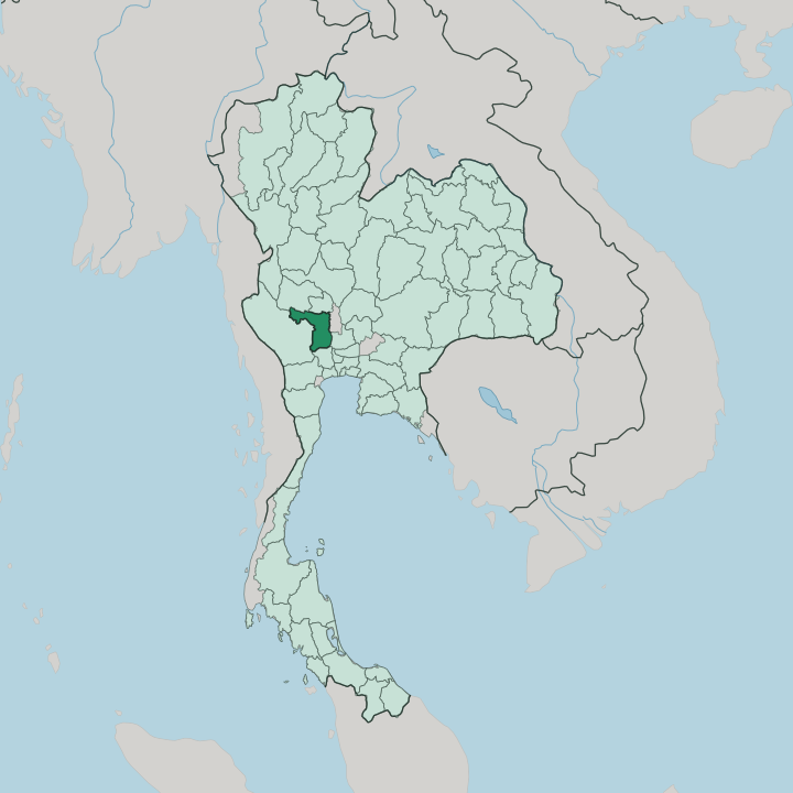


Towns & cities in Changwat Suphan Buri
Pick a town or city — each links to where to stay.
Four bases divide the province. Suphan Buri town is the natural first stop, its hotels gathered on the Tha Chin River near Wat Pa Lelai and the widest run of onward roads. For heritage, sleep at Sam Chuk, where wooden shophouses and kanom stalls crowd a century-old market on the same river.
U Thong suits travellers drawn to the moated earthworks and museum of an ancient Dvaravati town. Dan Chang is the outlier, rising north-west into the forest and waterfalls of Phu Toei National Park, the province's only real upland.
About Changwat Suphan Buri
What is Changwat Suphan Buri known for?
Two things carry the province's name. One is a battle. The Don Chedi Monument marks the spot where tradition places King Naresuan's elephant-back duel with the Burmese crown prince, an event still re-enacted with costumed war elephants each January.
The other is water and rice, for the Tha Chin River feeds one of Thailand's oldest paddy landscapes. At Sam Chuk the riverbank keeps a wooden hundred-year market, while U Thong guards the earthworks of a Dvaravati city older than Ayutthaya itself.
Where is Changwat Suphan Buri?
Suphan Buri lies in the central plain of Thailand, part of the great lowland the Chao Phraya River built. It sits inland. The land tilts almost imperceptibly toward the south-east, where the Tha Chin River, called the Suphan River as it passes the capital, spreads a flat quilt of paddy across the province.
This is a river landscape, not a coastal one, and no sea touches its edges. Water arrives instead as a web of canals, ditches and the seasonal flood that has fed rice here for centuries, one of the oldest cultivated plains in the kingdom. The flatness breaks only in the north and the west.
There the ground lifts into low forested ranges along the Kanchanaburi and Uthai Thani borders, the flat paddy finally giving way to forest. The highest ground rises at Khao Thevada, above the waterfalls and pine of Phu Toei National Park. Seven provinces ring Suphan Buri in all.
Uthai Thani and Chai Nat sit to the north, Sing Buri, Ang Thong and Ayutthaya to the east, Nakhon Pathom to the south, and the hills of Kanchanaburi close the western side. From the capital it is roughly a hundred kilometres north-west to Bangkok, an easy run down Highway 340 across the same unbroken plain.
What is Changwat Suphan Buri like?
Suphan Buri sings. The province is a heartland of luk thung, the country music of the Thai rice fields, and it gave the genre its first great star in Suraphol Sombatcharoen, the singer crowned its 'king.' Local speech carries part of that fame, for the Suphan Buri accent is prized as a soft, drawn-out drawl thought to preserve the tongue of the old Ayutthaya court. The same fields feed the country's oldest verse epic.
Khun Chang Khun Phaen, the long folk poem of two rivals and the woman between them, is set among these towns, and Wat Pa Lelai keeps a model of Khun Chang's house and cloister murals from the tale. Beyond music, the province eats and prays with the same plenty. Its ponds grow much of the nation's water chestnut, the crisp white kernel diced into thapthim krop, the ruby dumplings served in sweet iced coconut milk.
Faith runs deep. Wat Pa Lelai shelters Luang Pho To, a vast seated Buddha that draws pilgrims from across the plain, while in the capital a giant sculpted dragon houses the Dragon Descendants Museum, a monument to the Thai-Chinese who settled the river trade. Tai, Mon, Lao, Khmer and Chinese threads all run through the local weave.
What is the history of Changwat Suphan Buri?
The name means 'city of gold,' from the Sanskrit suvarna, and the gold is old. U Thong grew into a walled Dvaravati city long before Ayutthaya, trading with India and China across the plain. Later the town of Suphan Buri became a frontier fortress of the Ayutthaya kingdom, guarding the western road against Burmese armies.
War came often. Tradition sets King Naresuan's famous elephant-back duel with the Burmese crown prince here, the victory marked ever since by the Don Chedi Monument.
What is the climate of Changwat Suphan Buri?
Suphan Buri has a tropical savanna climate, hot through most of the year and split into three seasons. The hottest stretch runs from March into May, when the inland plain bakes and afternoons can climb toward the high thirties. Then the southwest monsoon breaks.
From May into October it drives the rains that flood the rice paddies and swell the Tha Chin River past its banks. A drier, cooler spell follows from November, the only weeks the nights turn genuinely mild. Rain, heat and harvest, the farming year turns on them.
How do you get to Changwat Suphan Buri?
There is no airport. Most travellers reach Suphan Buri from Bangkok, roughly a hundred kilometres to the north-west, by road. Buses leave the capital's Northern and Southern terminals through the day, and the drive up Highway 340 takes only a couple of hours across the flat plain.
A single-track branch railway also creeps in from Nong Pla Duk junction to the town's quiet terminus. Once inside the province, songthaews and hired cars link the market towns of Sam Chuk, U Thong and Don Chedi.
Updated July 2026