Thailand
Changwat Kanchanaburi, Thailand — Towns & Travel Guide


Kanchanaburi is a mountainous province in western Thailand, cut by the Khwae Yai and Khwae Noi rivers and bordering Myanmar.
About Changwat Kanchanaburi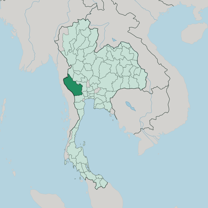


Towns & cities in Changwat Kanchanaburi
Pick a town or city — each links to where to stay.
Most visitors base themselves in Kanchanaburi town, on the riverfront strip of River Kwai Road a short walk from the war cemetery and the bridge. Upriver the choice changes. Floating raft houses ride the current of the Khwae Noi, reached by longtail boat and open to the jungle on both banks.
Further out, resorts cluster near Erawan National Park and along the Srinagarind reservoir, while Sangkhla Buri sits alone in the far northwest. Pick the town first.
About Changwat Kanchanaburi
Two things draw travellers here.
What is Changwat Kanchanaburi known for?
The first is the Death Railway, the Second World War line the Japanese army drove through the hills toward Burma, and its steel bridge over the Khwae Yai River near Kanchanaburi town. The second is water and forest. Erawan National Park pours down a seven-tier waterfall into pools the colour of jade, while Sai Yok National Park hides limestone caves and its own falls in the jungle.
Trains still cross the old bridge each day.
Where is Changwat Kanchanaburi?
Kanchanaburi spreads across the west of Thailand, the third-largest of the country's provinces and one of its wildest. Forest covers well over half of it. The land climbs from the plains around the provincial capital toward the Tenasserim Hills, the long chain that walls Thailand off from Myanmar and carries the border along its ridgeline.
At the Three Pagodas Pass, near the town of Sangkhla Buri, that ridge dips low enough to have served for centuries as the overland gate between the two countries. Steep limestone and dry forest fill the rest, protected in reserves such as Sai Yok National Park. Two rivers give the province its shape.
The Khwae Yai and the Khwae Noi both rise in the western hills and run down to Kanchanaburi town, joining there to form the Mae Klong. That combined river then flows east and south across the central plain, past Ratchaburi, and empties into the Gulf of Thailand. The Srinagarind Dam holds the Khwae Yai back behind one of the country's larger reservoirs, drowning old valleys under deep green water. Bangkok lies a couple of hours east by road.
Close, yet a different world.
What is Changwat Kanchanaburi like?
Two cultures sit side by side here. Down on the plain the life is Thai and Buddhist, ordered around the temple and the market and shadowed by the memory of the war. War remembrance shapes the capital.
Its cemetery holds thousands of Allied dead, and museums along the river tell the story of the men who built the Burma Railway. Trains still run out to Nam Tok along the surviving track, and a memorial walk climbs through the rock cutting at Hellfire Pass where the worst of the digging was done. In the cool months the town lights the old bridge for a memorial festival.
Climb west into the hills and the mix shifts. The border districts hold Mon people and Karen people who crossed from Myanmar over generations, and Thai is only one language heard in their markets. Sangkhla Buri is their centre.
A hand-built teak footbridge, the longest of its kind in the country, carries villagers across the reservoir to the Mon temple of Luang Phor Uttama each morning. When the lake drops in the dry months, the spire of a drowned temple breaks the surface offshore. North of the capital, the miners of Bo Phloi still dig blue sapphire from the ground.
The province wears its frontier lightly.
What is the history of Changwat Kanchanaburi?
People have lived by these rivers since the Stone Age, and the Ban Kao sites west of the capital hold Neolithic graves and pottery thousands of years old. In the thirteenth century the Khmer empire pushed a western outpost here, its temple still standing as Prasat Mueang Sing. The frontier bred war.
For centuries Burmese armies marched through Three Pagodas Pass toward the Thai heartland, and the province's darkest chapter fell in the Second World War. Then forced labourers and prisoners cut the Burma Railway through the hills, and tens of thousands died.
What is the climate of Changwat Kanchanaburi?
The province runs on three seasons, not four. Hot weather builds from March, when the lowland air turns heavy and the forest waits for rain. Then the southwest monsoon arrives, and from about May into October it drives storms against the western hills and fills the Khwae Yai and Khwae Noi to their banks; the waterfalls of Erawan National Park run hardest in these months.
The cool, dry season that follows, from November into February, is the kind time to come. Highland nights turn cold.
How do you get to Changwat Kanchanaburi?
Most travellers come from Bangkok, a couple of hours west by road. Buses and minivans run all day to the provincial capital. The other way in is the railway itself: the surviving stretch of the Burma Railway still carries a slow tourist train out from Bangkok, over the bridge on the Khwae Yai and along the cliffs to the end of the line at Nam Tok.
There is no airport of any size. Beyond the capital, roads climb west toward Myanmar and the crossings near Three Pagodas Pass, and a car earns its keep.
Good for
Updated July 2026