Turkey
Kütahya, Turkey — Towns & Travel Guide


Kütahya is an inland province of western Turkey, a historic tile and ceramic centre, rising from thermal-spring valleys to the ridges of Murat Dağı.
About Kütahya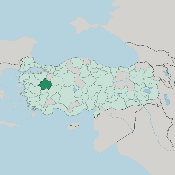


Towns & cities in Kütahya
Pick a town or city — each links to where to stay.
Most visitors base themselves in Kütahya, the provincial capital on the Porsuk River, where the tile workshops and the old bazaar sit within walking distance. The rest of the province is spa country. Simav, in the south-west, is built around the Eynal hot springs; Emet, further west, has its own thermal quarter; and Gediz sends bathers up to the resorts on Murat Dağı.
Pick the capital for tiles and history. Choose a thermal valley when you have come to soak.
About Kütahya
What is Kütahya known for?
Two things carry Kütahya's name beyond its borders: tiles and hot water. The province has thrown, glazed and painted pottery for centuries, and its workshops became the Ottoman world's second tile centre after İznik. Aizanoi, near Çavdarhisar, holds one of Anatolia's best-preserved Roman temples, raised to Zeus.
Thermal springs surface across the valleys, drawing bathers to Simav and Emet. Clay, ruins and steam. That mix is the draw.
Where is Kütahya?
Kütahya sits inland in western Turkey, on the hilly eastern edge of the Aegean region. The provincial capital stands high, close to a thousand metres, where the Porsuk River begins its run toward the Sakarya. Around it the land is mostly gentle: broad valleys and rolling farmland, sugar-beet fields and orchards.
Those slopes climb. To the north and west they rise into forested ridges, and Murat Dağı, on the border with Uşak, tops them all. East of the capital the ground breaks into the rocky Phrygian highlands, a country of tufa gorges and rock-cut tombs.
Tavşanlı in the north-west sits on the lignite that feeds the province's power stations. The province is landlocked, hemmed in by neighbours on every side. Eskişehir lies to the east and Afyonkarahisar to the south-east. Uşak is to the south, with Manisa and Balıkesir beyond the mountains to the west, and Bursa and Bilecik closing off the north.
No coast comes near. Rivers do the shaping here instead, the Porsuk draining the centre and the Gediz rising in the southern hills, and the roads follow their valleys from one ridge to the next.
What is Kütahya like?
Clay is the thread that runs through Kütahya. Potters here have shaped, glazed and fired tile and tableware for centuries, and the craft still fills the workshops that ring the old town. Blue-and-white and polychrome patterns of carnations, tulips and split-leaf arabesques cover the capital's fountains, mosque façades and shopfronts.
Kütahya china carries the name into ordinary kitchens across Turkey. Tiles here work as signatures as much as trade goods, the way the town quietly marks what it has made and fired for the rest of the country. The look is unmistakable.
The province wears its layers openly. Aizanoi's Roman temple, the Germiyanid mosques and tombs of the capital, and the battlefield of Dumlupınar to the south each mark a different chapter. Turkish is spoken everywhere across the province.
A dedicated tile museum fills a former Germiyanid madrasa in the centre, gathering centuries of the local craft under one roof. Kütahya also keeps an odd European footnote: the house where the Hungarian statesman Lajos Kossuth spent his exile serves as a museum on a lane in the old quarter. Museums, mosques and kilns sit close together.
The result is a working town rather than a stage set, one that still makes the thing it is known for.
What is the history of Kütahya?
Kütahya carries a long history. The Phrygians worked the highlands to its east, and the Romans knew the town as Cotyaeum, a stop on the road across Anatolia. In the medieval centuries it became the seat of the Germiyanids, a Turkish principality whose lands passed to the Ottomans by marriage and were absorbed by 1428.
Greek forces held the city during the war that followed the First World War. It was retaken in 1922, after the decisive Battle of Dumlupınar fought in the south of the province.
What is the climate of Kütahya?
Height sets the weather here. The capital sits close to a thousand metres up, so Kütahya has hard, snowy winters and warm, dry summers rather than the mild coast the Aegean is known for. Frost settles into the Porsuk valley for months.
The western basins around Simav and Emet, lower and more open to sea air, run a touch milder. Rain and snow favour the cold half of the year. Come summer, the plateau bakes.
How do you get to Kütahya?
Kütahya is a land journey. No coastline touches the province, so most people arrive by road or rail from the bigger cities around it. The İzmir-Ankara railway runs through the capital, and a regional airport shared with Afyonkarahisar and Uşak sits out on the Altıntaş plain.
Eskişehir, an hour to the east, is the nearest high-speed-rail hub. Drivers reach the thermal valleys of Simav and Emet on the provincial roads that thread between the ridges. Bring patience for the mountains.
Good for
Updated July 2026