Turkey
Uşak, Turkey — Towns & Travel Guide


Uşak is a province of inland western Turkey, a Lydian and Phrygian land between the Aegean coast and the Anatolian plateau.
About Uşak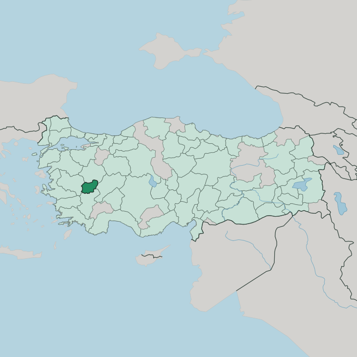


Towns & cities in Uşak
Pick a town or city — each links to where to stay.
Base yourself in Uşak. The provincial capital sits near the middle of the province, holds the Karun Treasure in its museum, and offers the widest choice of beds for a first night. Head south toward Ulubey and Karahallı to sleep by the canyon rim.
Weavers draw travellers west to Eşme, while Banaz anchors the farm country east of the city. Pick the capital first; choose the canyon towns or Eşme when you want the province closer.
About Uşak
What is Uşak known for?
Two things carry Uşak's name furthest: an ancient hoard and a great gorge. The Karun Treasure, a cache of Lydian gold looted from a burial mound, was smuggled abroad and later returned to the Uşak Museum of Archaeology. Nearby, the Banaz Çayı has cut the Ulubey Canyon, among the longest canyons in the world.
The province also gave Ottoman weaving its Uşak carpets, and the looms of Eşme still turn out flat-woven kilims. Antiquity and craft define it.
Where is Uşak?
Uşak lies in the interior of western Turkey, in the hilly hinterland of the Aegean Region rather than on the coast itself. It is a landlocked province. Manisa borders it on the west and Kütahya on the north, while Afyonkarahisar closes off the east and Denizli the south. The land here is a threshold, where the moist lowlands that drain to the Aegean give way eastward to the drier tableland of inland Anatolia.
Most of the province sits high, on rolling plateau country broken by ridges and river valleys. Water has shaped it. The Banaz Çayı runs down through the province and feeds the Büyük Menderes, the great river that carries Uşak's rain toward the Aegean far to the west.
Along its course the stream has carved the Ulubey Canyon, a gorge tens of kilometres long that ranks among the world's longest. The provincial capital, Uşak, stands near the centre, roughly a couple of hours inland from the port of İzmir. Around it spread the farming districts of Banaz, Eşme, Sivaslı, Ulubey and Karahallı.
Together they make a compact province, crossed in a single day.
What is Uşak like?
Weaving is the thread that runs through Uşak. From the Ottoman centuries its workshops turned out the Uşak carpets, star- and medallion-pattern rugs whose designs turn up in the backdrops of Renaissance European painting. Antique examples hang in museums well beyond Anatolia.
The old knotted carpet has largely given way to the flat-woven kilim, cheaper to make and quicker to sell. That craft settled in the west, around Eşme and the village of Takmak, where a kilim festival fills the calendar each spring. Leather and textiles still drive the workaday economy.
Deep history feeds local pride. The return of the Karun Treasure, Lydian gold once smuggled out and finally reclaimed, gave the province a symbol it guards closely in the Uşak Museum of Archaeology. The table is Anatolian and hearty.
Tarhana soup, dried from fermented grain and yoghurt, is the province's signature, and keşkek, höşmerim and tahini halva round out a kitchen built for cold uplands. Turkish is the everyday language, as across the country. Life beyond the capital stays rural, tied to grain, sugar beet and grazing on the high plateau.
This is working country.
What is the history of Uşak?
Uşak's story is old. Phrygians held the eastern hills and Lydians the western valleys by the 7th century BC, and the Karun Treasure, gold from a Lydian tomb, dates from that world. A town called Temenothyrae stood here through Roman and Byzantine times.
Much later the Germiyanid beylik ruled from nearby Kütahya, until its last prince, Yakub II, bequeathed his lands to the Ottoman Empire in 1429. Carpet-weaving grew under Ottoman rule and carried the town's name into Europe.
What is the climate of Uşak?
Altitude rules the weather. Uşak sits high on the inland plateau, far from the moderating Aegean, so its summers turn hot and bone-dry while winters bring hard frost and snow. Rain and snow fall mostly in the cold months, feeding the Banaz Çayı that runs down to the Büyük Menderes.
The transitional seasons are brief on this plateau. Spring and autumn slip past in a matter of weeks. It is a Mediterranean pattern pushed toward the continental by height and distance from the sea.
How do you get to Uşak?
Most travellers come overland from İzmir. The coast and its port lie a few hours west, and the main road climbs inland from there onto the plateau. Uşak keeps a small domestic airport of its own.
A railway threads through as well, on the old line that links İzmir with Afyonkarahisar by way of the province. From Kütahya to the north and Denizli to the south, good highways feed into the capital. Once inside the province, it is easy ground to drive.
Updated July 2026