Turkey
Yozgat, Turkey — Towns & Travel Guide


Yozgat is a high, cold province of central Turkey, where black-pine woods stand on open steppe above the upper Kızılırmak.
About Yozgat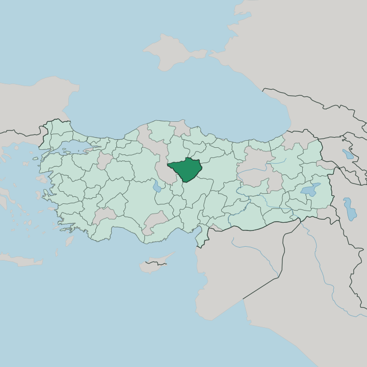


Towns & cities in Yozgat
Pick a town or city — each links to where to stay.
Most travellers base themselves in Yozgat, the provincial capital, within reach of the Çapanoğlu Mosque and the pine woods of Çamlık on the ridge above. The province is spa country. Sorgun and Sarıkaya draw people to their hot springs, Sorgun for its cluster of thermal hotels and Sarıkaya for the open Roman pool of Basilica Therma.
Yerköy guards the western approach, where the Ankara road and the railway come in. Pick the capital for heritage; pick Sorgun or Sarıkaya to soak.
About Yozgat
What is Yozgat known for?
Two names built Yozgat: the Çapanoğlu family and the plateau itself. The eighteenth-century Çapanoğlu dynasty turned a Bozok village into a provincial seat, and their Ottoman-Baroque great mosque still anchors the capital. Wood is the surprise here.
Just south of town, the black pines of Yozgat Çamlığı stand as Turkey's first national park, a rare forest marooned on open steppe. The province is also thermal country, with hot springs at Sorgun and the Roman pool of Basilica Therma at Sarıkaya. Folk music runs deep, and the Sürmeli türkü carries the name of Yozgat across Turkey.
Where is Yozgat?
Yozgat sits in the heart of the Anatolian plateau, on the high, treeless steppe that fills the middle of Turkey. The land runs high. Most of the province lies a kilometre or more above the sea, a rolling upland of grain fields and bare ridges cut by shallow river valleys.
Mountains close off the east, where the Akdağ range climbs past the mining town of Akdağmadeni, and the Çamlıbel and Karababa ridges wall the northern edge. Eight provinces ring it. Çorum and Amasya lie along the north, Tokat and Sivas to the east, Kayseri and Nevşehir across the south toward Cappadocia, and Kırşehir and Kırıkkale to the west. The province drains two ways.
Most of it goes to the Kızılırmak, Turkey's longest river, which curls around the western and northern rim and takes in the Delice, a tributary that forms near Şefaatli and drains the grain valleys. Only the northern corner tilts the other way, its Çekerek valley draining northeast to the Yeşilırmak instead. The steppe is nearly bare of trees, which makes the one great exception famous.
Just south of the capital, the black pines of Yozgat Çamlığı cover a low hill, a relic pine wood protected as Turkey's first national park. Higher up, the granite dome of Kerkenes Dağ carries the ruins of a vast Iron Age city, its seven-kilometre wall drawn across the mountaintop above the plain.
What is Yozgat like?
Yozgat wears the Çapanoğlu family's stamp. The great mosque they raised in the town is a burst of Ottoman Baroque, its prayer hall painted with garlands and curling foliage that owe as much to Europe as to Istanbul. Old timber mansions stand nearby.
The Nizamoğlu konak, a wooden Ottoman house, holds the provincial museum. Music is the other inheritance. The Yozgat Sürmelisi, a slow türkü of longing sung to the bağlama, carries the province's name through Turkish folk music, and every August the Sürmeli festival fills the town with players, dancers and wrestlers.
The table leans hard into winter. Arabaşı, a thick soup of chicken and flour eaten with a gelatinous dough pinched off by hand, is the dish Yozgat claims as its own, a warmer against the plateau cold. Meat comes slow-cooked.
Testi kebabı is sealed in a clay pot and cracked open at the table, while keşkek pounds mutton and wheat into a festival stew. Beyond the town it is farming country, worked in Turkish like the rest of the province, where wheat, sugar beet and grazing flocks set the rhythm of the year across the Bozok uplands the Çapanoğlu once governed.
What is the history of Yozgat?
People worked these uplands long before the Ottomans; the mound at Alişar Höyük was a walled town in the Bronze Age, and the ruined city on Kerkenes Dağ may be the Pteria that Croesus stormed. For the Ottomans this was Bozok, a sanjak of grazing land on the road east. Its fortunes turned in the eighteenth century, when the Çapanoğlu notables of Turkoman stock made Yozgat their seat and built it up with mosques, baths and a market.
Their great mosque went up in 1779. The dynasty faded as Istanbul reined in its provincial lords, and the town settled into the Turkish republic.
What is the climate of Yozgat?
Altitude, not the sea, sets the weather here. The plateau lifts Yozgat well above a kilometre, and that height buys long, hard winters. Snow settles over the Çamlık pines and the surrounding steppe from late autumn, and the town ranks among the coldest provincial capitals in Turkey, with deep frosts and drifts on the Akdağ passes.
Summers swing the other way, warm and parched, the grain country baking under a dry sky. Spring is short and comes late.
How do you get to Yozgat?
No planes land in Yozgat. Travellers fly instead into Kayseri to the south or Ankara to the west, then finish the trip by road, each airport a few hours out across the plateau. The province rides the main line east.
A high-speed railway between Ankara and Sivas runs through it, stopping at Yerköy, Yozgat and the spa town of Sorgun, and the old Ankara-Sivas highway threads the same valley for drivers and the intercity buses. Most travellers reach Yozgat by road or rail.
Updated July 2026