Canada
Nunavut, Canada — Towns & Travel Guide


Nunavut is Canada's largest and northernmost territory, an Arctic expanse of tundra and islands with Iqaluit as its capital.
About Nunavut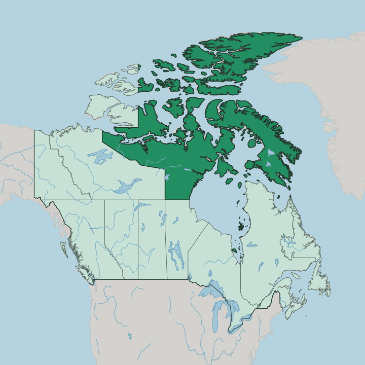
Towns & cities in Nunavut
Pick a town or city — each links to where to stay.
Beds cluster in a handful of communities, and the three administrative regions each have a hub. Iqaluit is the obvious base. It has the most rooms and the only flights that connect straight to southern Canada.
Rankin Inlet anchors the Kivalliq region on the western shore of Hudson Bay, and Cambridge Bay serves the Kitikmeot region in the west. From any of these hubs, smaller hamlets are reached by a further bush flight. Pick Iqaluit for a first Arctic trip; choose Rankin Inlet or Cambridge Bay to reach the mainland tundra and the central archipelago.
About Nunavut
What is Nunavut known for?
Nunavut is Canada's newest territory, carved out of the Northwest Territories in 1999 as an Inuit homeland. Its name means "our land" in Inuktitut. Larger than Mexico yet home to only a scatter of coastal communities and offshore islands, the territory has no road linking one settlement to the next, so the plane is the thread that ties it together.
Iqaluit, the capital, sits on Baffin Island at the head of Frobisher Bay. Every visitor arrives by air. The great draw is the Arctic itself: sea ice, muskox and caribou, the summer's endless daylight, and the winter's long dark.
Where is Nunavut?
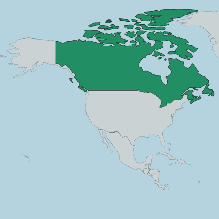
Nunavut fills the top of Canada. It stretches from the Manitoba border in the south to Ellesmere Island in the far north, the closest Canadian land to the pole. The territory splits between a mainland tundra along Hudson Bay and the vast Arctic Archipelago that spreads across the Arctic Ocean beyond.
That archipelago is a maze of more than thirty thousand islands. Baffin Island dominates the east, the largest island in Canada and the fifth largest on Earth, and Iqaluit stands on its south-eastern shore at the head of Frobisher Bay. Water does most of the dividing.
Hudson Bay bites deep into the mainland from the south, and the Northwest Territories lie along the western edge. To the east, Baffin Bay and the Davis Strait separate Nunavut from Greenland. The land itself is low, treeless tundra and bare rock, much of it locked under continuous permafrost that never fully thaws.
Distances here are enormous. No highway crosses the territory, no railway reaches it, and the communities sit far apart along the coasts and the islands with open tundra and frozen sea between them.
What is Nunavut like?
Nunavut is Inuit land, and that shapes everything. Inuit make up the large majority of the population, and Inuktitut is spoken alongside English in homes, schools and the territorial assembly. The word Nunavut means "our land," and the territory was created so the Inuit could govern that land themselves.
Older knowledge still guides daily life. Inuit Qaujimajatuqangit, the body of traditional teaching passed down through generations, informs how the government works and how people read the ice, the weather and the animals. The Inuit have lived across this Arctic for thousands of years, descended from the Thule people who spread east over the archipelago.
That long inheritance shows in the art. Carvers work soapstone and antler into muskox, bears and hunters, and printmakers from communities such as Cape Dorset built a reputation that reaches galleries far to the south. Throat singing, drum dancing and the winter games keep older forms alive.
Hunting and fishing are not a pastime but a way of feeding a family, and country food such as seal and caribou and Arctic char sits at the centre of the table.
What is the history of Nunavut?
Nunavut is young as a jurisdiction but ancient as a homeland. The Inuit and their Thule ancestors have lived across this Arctic for thousands of years, long before any map named it. The modern territory grew from a land claim: the Nunavut Land Claims Agreement, whose boundaries were drawn in 1993, settled Inuit title over the region and set the terms for self-government.
Then came the split. On April 1, 1999, Nunavut was carved from the Northwest Territories to become its own territory, the first change to Canada's internal map since Newfoundland joined in 1949.
What is the climate of Nunavut?
Nunavut has a true Arctic climate. Winters are long and severe, with stretches well below freezing and, in the far north, weeks when the sun never clears the horizon. Summers are short and cool, and even in the warmest spots the thermometer rarely climbs far.
The daylight swings to the other extreme in June, when the sun barely sets over Iqaluit and the high archipelago. Continuous permafrost underlies almost the whole territory, keeping the ground frozen hard beneath a thin surface that thaws for only a few weeks each year.
How do you get to Nunavut?
You fly. No road or railway reaches Nunavut from the rest of Canada, so the plane is the only practical way in. Iqaluit, on Baffin Island, takes jets straight from Ottawa and other southern cities and serves as the main entry point for the east.
Rankin Inlet, on Hudson Bay, is the hub for the Kivalliq region and links to Winnipeg. Between communities there are no highways at all; smaller planes hop from hub to hamlet, and in the brief open-water season a summer sealift barge brings in heavy freight and fuel.
Good for
Updated July 2026