Democratic Republic of the Congo
Lomami, Democratic Republic of the Congo — Towns & Travel Guide


Lomami is a young province in the south-centre of the Democratic Republic of the Congo, named for the river that crosses it.
About Lomami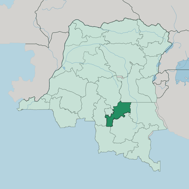


Towns & cities in Lomami
Pick a town or city — each links to where to stay.
Beds cluster in the two towns that matter here. Kabinda, the capital, is the administrative base, a plateau town of red-earth streets served by Tunta Airport and the Catholic diocese that has anchored it for a century. Mwene-Ditu sits south on the Kasai railway, busier and more mercantile, the province's real trading hub where the diamond trade and long-haul road traffic converge.
Choose Kabinda if you have official business in the capital; choose Mwene-Ditu if you are moving through by rail or road. Beds are simple. Formal lodging in both towns is thin, basic, and best arranged before you arrive.
About Lomami
What is Lomami known for?
Lomami takes its name from the Lomami River, which rises in the Katanga highlands to the south and runs north across the province toward the Congo. Its two anchor towns are Kabinda, the provincial capital on the savanna plateau, and Mwene-Ditu, the larger commercial town on the rail line south. Diamonds draw artisanal miners around Lubao and Luputa.
Farming feeds everyone else. The far north edges into the dense rainforest of Lomami National Park, home to the Lesula monkey and its own distinct bonobos.
Where is Lomami?
Lomami sits in the south-central Democratic Republic of the Congo, one of the provinces carved out of the old Kasaï-Oriental in 2015. The Lomami River gives the province both its name and its spine. It rises in the Katanga highlands to the south, then flows north across the plateau on its long course toward the Congo, which it eventually joins far downstream at Isangi.
Most of the province is upland savanna and open woodland, a plateau standing well above the great river basins that surround it. The land is neither pure forest nor pure grassland. It is a mosaic, with gallery forest tracing the rivers that drain northward and open savanna covering the higher, drier ground between them.
The south, around Mwene-Ditu, is farming and mining country. Northward the country tilts down toward the Congo Basin, and the savanna gives way to the dense rainforest that fills the far north of the province inside Lomami National Park. Kasaï-Oriental lies to the west, Haut-Lomami to the south-east, and Sankuru to the north.
One thread runs through all of it. The Lomami River is the constant that ties these very different halves together.
What is Lomami like?
Lomami is Luba and Songye country. The Luba, a Bantu people whose old kingdom once held much of south-central Congo, are the majority across the plateau, and their language Tshiluba is spoken everywhere alongside French. The Songye live mainly toward the Lomami River and share close ties of language and kinship with their Luba neighbours.
Carving is their inheritance. Songye workshops are known far beyond the province for their power figures and masks, wooden sculptures bristling with copper, nails and horn, carved to protect and to heal. Daily life runs on farming and fishing, the same rhythm the river has set for generations.
Cassava, maize and groundnuts come off the fields. Fish come from the Lomami and its tributaries. Markets in Kabinda and Mwene-Ditu pull the two towns and the villages between them into one economy, and it is in those markets, more than anywhere, that the province feels like a single place rather than a line drawn on a map in 2015.
What is the history of Lomami?
The name Lomami is old, but the province is new. A first Lomami province was drawn from Kabinda district in 1962, only to be folded back into Kasaï-Oriental in 1966, where it stayed for nearly half a century. Then came 2015.
The redrawing of the country's map split that big province apart and brought Lomami back, built from Kabinda district and the separately run town of Mwene-Ditu. Kabinda, long a Belgian colonial post on Luba and Songye land, became the capital of the restored province.
What is the climate of Lomami?
Lomami has a tropical climate split into a wet half and a dry half. The rains fall roughly from November to March, the dry season runs from April to October, and the plateau's height keeps the heat a shade gentler than the low Congo Basin to the north. Rain feeds the gallery forests along the Lomami River.
The seasons rule travel here. It is the wet season that swells the river and its tributaries, and the dry season that opens the savanna roads between Kabinda and Mwene-Ditu.
How do you get to Lomami?
Getting to Lomami takes patience. The surest overland route is the Kasai railway, which climbs from the river port of Ilebo through Kananga to Mwene-Ditu, the province's rail gateway and its busiest town. Road links the two capitals of the province across the plateau, though the going depends heavily on the season.
Kabinda has its own small airfield at Tunta Airport. Long distances and rough roads make every journey here a slow one.
Updated July 2026