Democratic Republic of the Congo
Province du Nord-Kivu, Democratic Republic of the Congo — Towns & Travel Guide


Province du Nord-Kivu wraps the Congolese shore of Lake Kivu, from Goma up to the volcanoes of Virunga.
About Province du Nord-Kivu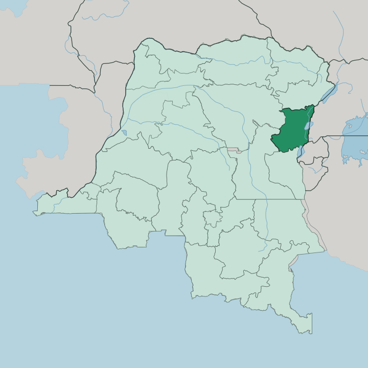


Towns & cities in Province du Nord-Kivu
Pick a town or city — each links to where to stay.
Goma holds the beds. The capital lines the north shore of Lake Kivu and sits within sight of Mount Nyiragongo, close enough that you can walk across the frontier from Gisenyi in Rwanda in a matter of minutes. From the city, trekkers push north into Virunga National Park to reach the gorilla sectors near Bukima.
Farther up the province, the trading cities of Butembo and Beni serve their own hinterlands, not tourists. Base yourself in Goma for the lake, the volcano, and the sectors of the park; the rest of Nord-Kivu is worked, not visited.
About Province du Nord-Kivu
Mountain gorillas.
What is Province du Nord-Kivu known for?
Province du Nord-Kivu holds most of Virunga National Park, the oldest protected area on the continent and one of the last refuges of the mountain gorilla. Two active volcanoes anchor it: Mount Nyiragongo, whose summit crater cradles a churning lava lake, and its neighbour Nyamuragira just to the north. Goma sits below them on the north shore of Lake Kivu, hard against the Rwandan border, the province's capital and the doorway most travellers use to reach the park.
Where is Province du Nord-Kivu?
Province du Nord-Kivu occupies the far east of the Democratic Republic of the Congo, along the great trough of the Albertine Rift. Its whole eastern flank is a border. Rwanda faces it across Lake Kivu in the south-east, and Uganda meets it in the north-east, so the province looks out on two neighbours at once.
Lake Kivu forms the south-eastern edge, one of the deepest lakes in Africa and a body of water charged with dissolved gas far below its surface. To the north the land falls toward Lake Edward, a shallower rift lake shared with Uganda. Between the two lakes rises the Virunga chain.
It is a line of active volcanoes straddling the frontier, and Mount Nyiragongo stands closest to Goma while Nyamuragira smoulders a little to its north, both of them held inside Virunga National Park. Away from the rift floor the province climbs into cool, forested highlands around Butembo and Lubero, where the altitude tempers the equatorial heat. Ituri lies to the north-west.
Maniema and South Kivu close it off to the south-west and the south. This is a province defined less by any single centre than by the wall of mountains and the string of lakes down its eastern side.
What is Province du Nord-Kivu like?
Nord-Kivu is one of the most crowded and most mixed corners of the Congo. Many peoples share it. The Nande dominate the northern territories around Butembo and Lubero, the Hunde and Nyanga hold the central highlands of Masisi and Rutshuru, and Kinyarwanda-speaking Hutu and Tutsi communities live along the Rwandan border.
Batwa forest people trace the oldest presence of all in the hills. Swahili is the common tongue of the streets and the markets, the language that lets a Nande trader and a Hunde farmer strike a deal, while French carries the administration and Kinande sounds at home in the northern districts. Trade runs in the blood of the place.
Butembo built itself into a merchant city on coffee, cattle, and the long roads north to Uganda, its Nande traders famous across the region for reaching markets far beyond the province. Down on the lake, Goma mixes volcanic grit with the energy of a border town: money changers, motorbike taxis, and lake boats loading for the crossing to Bukavu. The land is fertile and worked hard, its slopes green with plantain, bean, and potato.
Conflict has scarred the province for a generation, and yet its markets keep trading and its music keeps playing. Endurance is part of the character here.
What is the history of Province du Nord-Kivu?
Kivu was carved out of the wider Belgian Congo and given district rank under colonial rule, then reorganised again and again as the colony reshaped its map. Nord-Kivu took its present form as a separate province in 1988, when the old Kivu region was split into three. Volcano and war shaped the rest.
Mount Nyiragongo buried much of central Goma under lava in 2002 and sent molten rivers toward the city again in 2021, and the fighting that spilled out of the Rwandan genocide of 1994 turned the province into one of the most contested grounds in Africa. Through all of it Goma has stayed the capital and the pivot of eastern Congo.
What is the climate of Province du Nord-Kivu?
Altitude, not season, sets the weather here. Sitting on the equator but lifted high above it, Goma and the Lake Kivu shore stay mild and spring-like the year round, far cooler than the equator alone would suggest. Higher still, the hills around Butembo and Lubero turn genuinely cool.
Mist clings to the forest and the nights bite. Rain falls in most months, heaviest in the two wet seasons that bracket the drier spells near the middle and end of the year. The high slopes of Virunga National Park can be cold and wet enough to need a warm layer on a gorilla trek.
How do you get to Province du Nord-Kivu?
Most travellers arrive overland from Rwanda. The usual route flies into Kigali, drives west to Gisenyi, and crosses the border on foot into Goma, a walk of a few minutes between the two lakeside towns. Goma keeps its own airport on the lava plain, though scheduled international flights into it are few.
From the capital it is a road journey north into Virunga National Park to reach the gorilla sectors around Bukima, and a boat ride down Lake Kivu to Bukavu in the neighbouring province. The far north around Beni and Butembo also connects by road to Uganda.
Good for
Updated July 2026