Democratic Republic of the Congo
Province du Kongo Central, Democratic Republic of the Congo — Towns & Travel Guide


Kongo Central is the only province of the Democratic Republic of the Congo that reaches the Atlantic, along the lower Congo River.
About Province du Kongo Central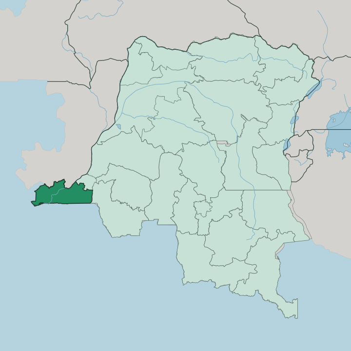


Towns & cities in Province du Kongo Central
Pick a town or city — each links to where to stay.
Kongo Central is read along its river. Matadi, the capital, is the obvious base: the chief seaport, terraced up the hills of the Congo River's left bank at the last point ocean ships can reach. Boma, the second port and the old colonial capital, sits further downstream toward the sea.
Muanda holds the province's beaches, out where the river empties into the Atlantic, though rooms along that short coast are few. Choose Matadi for the working port capital, Boma for the river-town past, or Muanda when you want the ocean.
About Province du Kongo Central
What is Province du Kongo Central known for?
This is the Congo's only window on the sea. The lower Congo River crosses the province from the north-east down to the Atlantic, and everything here is arranged around that water. Matadi, the provincial capital, is the country's chief seaport, sitting on the left bank at the last point ocean ships can reach before the rapids begin.
Two ports define it. Downstream lie Boma, the second port, and the beach town of Muanda where the river meets the sea. Upriver, the Inga Falls drop the whole Congo through cataracts that drive the Inga dams.
Where is Province du Kongo Central?
Kongo Central fills the far western corner of the Democratic Republic of the Congo, the one province that touches the sea. The lower Congo River runs the length of it, entering from the north-east near Kinshasa and cutting south-west to the Atlantic. That river is the spine of the province.
Ocean ships come up it as far as Matadi and no further, because the rapids of the Inga Falls block the way above the port. Below Matadi the river widens and slows past Boma before it reaches the coast. The whole Atlantic frontage is short.
The Congo meets the ocean at Muanda, and the province's entire seaboard runs only about 37 kilometres between the river mouth and the Angolan border. Beyond the water, the land climbs into low hills and cataract country in the middle of the province, and rises north of the river into the Mayombe, a belt of low mountains under dense tropical forest. Angola presses in on two sides.
Its Cabinda enclave lies to the north across the river, and the rest of Angola runs along the southern border, so this narrow neck of Congolese territory is squeezed between Angolan land and the sea. Kinshasa, the national capital, sits just off the province's north-eastern edge. Everything of consequence still bends back toward the one river.
What is Province du Kongo Central like?
This is Kongo country in the oldest sense. The province takes its name from the Kongo people, and their language, Kikongo, is heard across it alongside the official French. The word carries weight here.
Matadi itself means stone in Kikongo, a plain description of the rock the port is cut into above the river. The land was the western heartland of the Kingdom of Kongo, the state that ruled much of this region for centuries before the colonial border cut its old territory in two. Much of daily life still turns on the river and the port.
Matadi and Boma work as trading towns, moving the country's imports and exports up and down the Congo, while the fishing settlements along the coast at Muanda face the Atlantic instead. Palm oil, timber from the Mayombe forest, and the traffic of the seaport shape the working rhythm. The result is a province with a firm Kongo identity and an outward, sea-facing edge that the rest of the landlocked country does not share.
What is the history of Province du Kongo Central?
Long before the colony, this was the western ground of the Kingdom of Kongo, founded around 1390 and centred on Mbanza-Kongo just over what is now the Angolan border. When Europeans arrived by sea, the mouth of the Congo River became their door into the interior. Boma served as the capital of the Congo Free State and then the Belgian Congo from 1886 until 1923, when the seat of government moved upriver to what is now Kinshasa.
The Belgians called the district Bas-Congo, or Lower Congo. That name held for decades. It was renamed Kongo Central only in 2015.
What is the climate of Province du Kongo Central?
Kongo Central runs hot and tropical the year round. It follows a wet-and-dry rhythm rather than four seasons, with a long rainy stretch and a cooler, drier break in the middle of the year when the Atlantic keeps the coast around Muanda a little fresher. Rain feeds the Mayombe forest north of the river, where the dense cover holds moisture and the low mountains stay green.
Inland, around Matadi and the cataracts, the air turns heavy and warm. The humidity rarely lets go.
How do you get to Province du Kongo Central?
Most travellers come overland from Kinshasa, just off the province's north-eastern edge. A paved road and a rail line run down from the national capital to Matadi, following the drop of the Congo River toward the sea. The river carries the province's cargo but is closed to ships above the Matadi rapids, so the sea route ends at the port rather than continuing inland.
From Matadi the road pushes on to Boma and out to the coast at Muanda and Banana. Angola lies close south.
Good for
Updated July 2026