Democratic Republic of the Congo
Kasai Province, Democratic Republic of the Congo — Towns & Travel Guide


Kasaï Province is a diamond-rich region of the Democratic Republic of the Congo, built around Tshikapa and the Kasai River.
About Kasai Province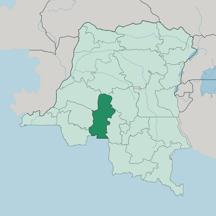


Towns & cities in Kasai Province
Pick a town or city — each links to where to stay.
Tshikapa is the practical base. The provincial capital stands at the confluence of the Tshikapa and Kasai rivers, and it holds nearly all of the province's formal lodging, administration and trade. Everything outside it is small.
The five territories of Dekese, Ilebo, Kamonia, Luebo and Mweka are thinly served, so travellers who venture into them arrange rooms and river transport through local contacts rather than any booking desk. Choose Tshikapa if you want a bed and a fixed point; treat the territories beyond it as trips out from that centre.
About Kasai Province
Diamonds define Kasaï.
What is Kasai Province known for?
The province grew up around the diggings at Tshikapa, where prospectors for the Forminière consortium first turned up gem-quality stones in the years before 1911, and diamond mining has been the mainstay of the local economy ever since. Its capital sits at the meeting of the Tshikapa and Kasai rivers, the second of which lends the whole province its name. Beyond the mines, the land is savanna and gallery forest cut by tributaries of the Kasai River, and its people are drawn from the Bakuba, Bapende, Chokwe and Bena-Lulua among many others.
Where is Kasai Province?
Kasaï Province lies in the south of the Democratic Republic of the Congo, along the country's border with Angola. It takes its name from the Kasai River, the great left-bank tributary of the Congo River that rises in the highlands of central Angola and swings north to trace part of the frontier before it enters the country. Tshikapa, the capital, sits where the smaller Tshikapa River joins that larger stream.
Kananga, the seat of neighbouring Kasaï-Central, lies well to the east. The land itself is a mix. Open savanna covers much of the south, giving way to gallery forest and denser woodland along the rivers and toward the north, where the Kasai and its tributaries thread the province.
Five territories divide it: Dekese, Ilebo, Kamonia, Luebo and Mweka. Ilebo, a river port in the north, once marked the point where goods moved between rail and the water route down to the Congo River. Angola lies close to the south, its border only a short run below Tshikapa.
Rivers, not roads, have long been the real map here.
What is Kasai Province like?
Many peoples share this ground. The Bakuba are the best known, a kingdom whose weavers and carvers gave the wider world its raffia cut-pile cloth and its bold geometric masks, and their heartland sits in the territories around Mweka. Alongside them live the Bapende, the Chokwe, the Bena-Lulua and communities of Luba-Kasaï, each with its own masking and dance traditions.
French is the official language of government and school. Day to day, most people speak Tshiluba, the Bantu tongue that carries across Kasaï and links Tshikapa with Kananga to the east. The diamond diggings shape the rhythm of ordinary life as much as any custom does, drawing people from the villages to the river bars where stones are found and sold.
Faith runs through it too, in Catholic parishes and a dense weave of independent Congolese churches. Art here is worn and danced, not shelved. It lives in cloth, in carved wood, and in the masquerades that still mark births, deaths and the turning of the seasons across the province.
What is the history of Kasai Province?
Kasaï Province in its present form is young. It was created in 2015, when the old province of Kasaï-Occidental was split into two, and the Kasaï district joined with the separately run city of Tshikapa to form the new unit under that capital. The deeper story is diamonds.
Tshikapa itself grew out of a mining camp founded early in the twentieth century by the Forminière consortium, which discovered gem-quality stones in the surrounding gravels and turned the confluence into a company town. That single find fixed the shape of everything that came after.
What is the climate of Kasai Province?
Kasaï has a tropical savanna climate, hot through the year. The wet months are long, running from about September to May, when the rains feed the Kasai River and its tributaries and green the savanna. A short, cooler dry spell settles over Tshikapa in June and July.
The wet season is drawn out rather than fierce, so downpours come in bursts and the sun returns fast. Humidity stays high near the rivers.
How do you get to Kasai Province?
Flying is the sensible way in. Tshikapa has its own airport, and air links to Kinshasa spare travellers a punishing overland trip across a province where paved road is scarce. Kananga, the neighbouring capital, lies to the east and is the nearest large city by land.
The Kasai River carries barge and pirogue traffic, the old artery that once fed the river-and-rail route north from Ilebo toward the Congo River. Angola sits just to the south, though the frontier is not a routine tourist crossing.
Updated July 2026