Democratic Republic of the Congo
Ituri, Democratic Republic of the Congo — Towns & Travel Guide


Ituri is the far north-eastern corner of the Democratic Republic of the Congo, holding rainforest, the Blue Mountains and the shore of Lake Albert.
About Ituri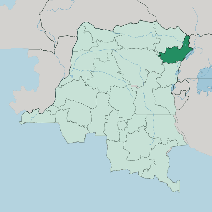


Towns & cities in Ituri
Pick a town or city — each links to where to stay.
Bunia is the one obvious base. The regional capital sits on the plateau some way west of Lake Albert, and it holds Bunia Airport along with nearly all of Ituri's guesthouses. Beyond it, beds thin out fast.
Epulu, the forest station inside the Okapi Wildlife Reserve, is where you go to see okapi and to walk with Mbuti trackers, though lodging there is basic. The Lake Albert shore, strung with fishing settlements below the Blue Mountains, is a rougher option again. Choose Bunia if you want a room, power and a flight out.
About Ituri
Ituri is forest country.
What is Ituri known for?
The Ituri Rainforest spreads across much of the region, roughly 63,000 square kilometres of dense evergreen canopy in the north-east of the Democratic Republic of the Congo. It is the home of the okapi, the shy forest relative of the giraffe found nowhere else on earth, and of the Mbuti and Efe hunter-gatherers who have lived under these trees for generations. One slice of that forest, the Okapi Wildlife Reserve around Epulu, carries a UNESCO World Heritage listing.
Gold made the region's other name.
Where is Ituri?
Ituri fills the north-eastern shoulder of the Democratic Republic of the Congo, pressed against the border with Uganda. Its eastern edge is water. Lake Albert lies along that side, a long rift lake shared with Uganda, and the Blue Mountains rise steeply behind the Congolese shore.
Locals call them the Monts Bleus, and their western slopes send the Ituri River down toward the interior. From the lake the land climbs to a broad plateau, and Bunia stands on it well above the water. West of that plateau the ground falls away into the Ituri Rainforest.
That forest is the region's great mass. It rolls out over some 63,000 square kilometres of the lowland interior, drained by the Ituri River, which gathers other streams and feeds the Aruwimi River and finally the Congo River itself. So Ituri holds two worlds at once.
There is the open, elevated east around Bunia and the lake, savanna and farmland on the high plateau, and there is the low forest to the west, deep and wet under its closed canopy. The Okapi Wildlife Reserve sits inside that western forest, roughly a fifth of it, around the station at Epulu. Few regions pack such contrast into one border.
What is Ituri like?
Two ways of life share this ground. In the forest live the Mbuti and Efe, hunter-gatherers who move in small bands, net-hunt among the trees, and gather honey, fruit and mushrooms from the Ituri Rainforest. Anthropologists came here for exactly that reason, and the Mbuti became some of the most studied forest peoples on earth.
On the plateau the picture is different. Cattle-keeping Hema and farming Lendu work the open high country around Bunia, alongside Alur, Bira and Ngiti neighbours, growing coffee and cocoa on land that has been fought over as bitterly as any in the country. Swahili does the daily talking.
The eastern Congolese variety, sometimes called Bunia Swahili, is the lingua franca of the markets and the streets, while French remains the language of the state and the school. Trade, cattle, gold and forest all meet in Bunia. It is a working regional town rather than a showpiece, and its character comes from that daily mixing of cattle-herders and farmers with miners and forest people rather than from any monument.
The okapi, the region's own animal, stands on the reserve's emblem and on the Congolese banknote.
What is the history of Ituri?
Gold made Ituri. Belgian prospectors confirmed rich deposits near Kilo in 1903, and the Kilo-Moto mines that followed pulled labour, roads and Bunia itself into being on the eastern plateau. For decades the region was governed from afar, first inside the colony's Orientale province and later, after independence, as a district of the wider Congolese east.
Then rivalry over that same land and gold, between the cattle-keeping Hema and the farming Lendu, hardened into open war around the turn of the millennium and cost tens of thousands of lives. The redrawing of 2015 changed the map. Ituri became a province in its own right at last, with Bunia as its capital.
What is the climate of Ituri?
Ituri stays warm. Near the equator, its temperature barely shifts across the year, yet the high plateau around Bunia tempers the heat so its days feel milder than the lowland forest to the west, which is hotter and heavy with damp. Rain rules the calendar more than temperature does.
Wetter months run through much of the year, with a drier stretch over the middle of it, and the western forest drinks far more of that rain than the eastern lake shore. Mornings on the plateau can turn surprisingly cool.
How do you get to Ituri?
For most, the way into Ituri is by plane. Bunia Airport is the region's real front door, since the roads are rough and there is no railway, and it takes domestic flights from Kisangani, Goma and the distant capital at Kinshasa. Lake Albert forms the eastern boundary with Uganda, and small lakeside crossings link the two shores by boat.
Overland routes exist too. They run toward Uganda in the east and through the forest to the west, but every one of them is slow, and in the wet months many turn to mud and become difficult to travel at all. From Bunia, tracks fan out to the plateau towns and into the Ituri Rainforest.
Good for
Updated July 2026