Algeria
Oum el Bouaghi, Algeria — Towns & Travel Guide


Oum El Bouaghi is a high-plains province of eastern Algeria, a land of wheat fields, salt lakes, and Chaoui Berber towns near Constantine.
About Oum el Bouaghi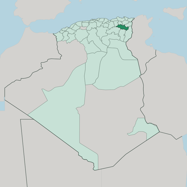


Towns & cities in Oum el Bouaghi
Pick a town or city — each links to where to stay.
Pick a town, then head out. Oum El Bouaghi, the capital, sits below the Sidi R'Ghis massif and keeps the provincial offices, while Aïn Beïda to the east is the larger commercial centre, market town of the Harakta and keeper of Roman ruins in its central garden. Aïn M'lila guards the western approach from Constantine, close to the reed-fringed shallows of Chott Tinsilt.
The salt flats have no hotels. The flamingos of Garaet et Tarf are a day trip, with beds back in the towns.
About Oum el Bouaghi
Wheat and barley run to the horizon.
What is Oum el Bouaghi known for?
The province sits on the Hautes Plaines, the high plateau east of Constantine, and its wealth has always come from grain, olives, and flocks of sheep grazed across the steppe. Great salt lakes break the farmland: Garaet et Tarf and Chott Tinsilt draw wintering flamingos to their brackish shallows. Aïn Beïda and Aïn M'lila are the busy market towns.
The people are mostly Chaoui Berbers, and the Aurès Mountains rise to the south.
Where is Oum el Bouaghi?
Oum El Bouaghi lies in eastern Algeria, in the interior called the Aurès. It fills a stretch of the Hautes Plaines, the high steppe plateau that runs between the Tell Atlas near the coast and the Saharan Atlas along the desert. The land sits high.
Most of the province rests around 800 metres above the sea, an open rolling tableland of wheat and pale grassland with isolated massifs breaking the flat. The capital stands southeast of Constantine, below the Djebel Sidi R'Ghis, and the Aurès Mountains climb away to the south toward Batna and Khenchela. Nothing about it feels coastal.
Water here has nowhere to run. The wadis that cross the plateau drain inward into closed basins, not out to any sea, and where they pool they leave broad salt lakes. Garaet et Tarf is the widest, a shallow basin that lies mostly dry and salt-crusted through the warm months and floods only after the rains.
Chott Tinsilt spreads near Souk-Naâmane, and Sebkhet Ezzemoul lies beside it, both ringed by salt-loving scrub. These endorheic flats define the map. Beyond them the grain fields roll toward Aïn Beïda in the east and Aïn M'lila in the west, and the province shares its borders with Constantine, Khenchela, and Tébessa.
What is Oum el Bouaghi like?
This is Chaoui country. The people of the plains are mostly Shawiya Berbers, part of the wider Aurès heartland, and around Aïn Beïda the Harakta confederation has held the land for centuries. Many speak Shawiya, a Zenati form of Tamazight, alongside Arabic.
The rhythm of life is agricultural and pastoral. Families work the wheat and barley, keep flocks on the steppe, and gather at the weekly souk where grain, sheep, and wool change hands. Bread and couscous anchor the table, often with mutton from the same flocks that graze the salt-lake margins.
The towns wear their past plainly. Aïn Beïda keeps Roman stonework and old tunnels in a garden at its centre, a reminder that this plateau was Numidian long before it was French. Music leans to the Aurès style, driven by the gasba flute and the bendir frame drum at weddings and festivals.
Daily life is unshowy and rural. Hospitality is taken seriously here, and a stranger on the road is offered tea before questions. The province keeps its own quiet character, closer to the mountains of the Aurès than to the coastal cities of the north.
What is the history of Oum el Bouaghi?
Long before Rome, this plateau belonged to Numidia, the Berber kingdom whose seat at Cirta became the city of Constantine. The Romans held the plains as frontier country, and Aïn Beïda grew from the garrison town they called Marcimani, whose tunnels still lie under its central garden. The Arab conquest reached the high plains at the battle fought near Meskiana in 698.
Under French rule the capital was named Canrobert, later Sidi R'Ghis. Independence restored the name Oum El Bouaghi. The wilaya itself was drawn in 1974 from the old Constantine department, and in 1984 Khenchela and Mila were split away from it.
What is the climate of Oum el Bouaghi?
The plateau has a dry continental climate, and the altitude makes the winters bite. Summers run hot, clear, and rainless over the open steppe. Winters are long and cold, with frost most nights and snow dusting the higher ground toward the Aurès.
Rain is sparse, roughly a rainy season's worth spread across the cooler months, enough to green the wheat and briefly flood Garaet et Tarf before the summer sun bakes it dry again. Day and night swing far apart. It is a climate of extremes, not of mildness.
How do you get to Oum el Bouaghi?
There is no airport on the plateau itself. The usual arrival is Constantine, whose Mohamed Boudiaf International Airport lies a couple of hours' drive northwest, linked by the Constantine-Tébessa road that threads the whole province. A railway crosses the high plains as well, running from Aïn M'lila through Oum El Bouaghi to Aïn Beïda and on toward Tébessa, with halts at Aïn Fakroun and Meskiana.
Louage share-taxis fill the gaps between towns. Most visitors come overland, by road or rail, from Constantine or the eastern cities.
Good for
Updated July 2026